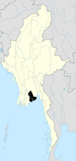
Photos • Location
Thongwa Township
သုံးခွ မြို့နယ် | |
|---|---|
Township of
Yangon Region | |
| Coordinates: 16°46′N 96°35′E / 16.767°N 96.583°E | |
| Country | |
| Region | |
| Township | Thongwa |
| Population (2009) | 156,993 |
| Time zone | UTC6:30 ( MST) |
| Area code | 056 |
| [1] | |
Thongwa Township ( Burmese: သုံးခွ မြို့နယ်) is a township of Yangon Region, Myanmar, located in the southeastern section of the region, by the Gulf of Martaban. [1]
- ^ a b "Profile of Thongwa Township" (PDF). Myanmar Information Management Unit (MIMU). April 2009. Retrieved 2011-02-19. [ dead link]


