Photos • Location
Kungyangon Township
ကွမ်းခြံကုန်း မြို့နယ် | |
|---|---|
Township of
Yangon Region | |
| Kungyangon Township | |
| Coordinates: 16°26′24.2″N 96°00′43.8″E / 16.440056°N 96.012167°E | |
| Country | Myanmar |
| Region | Yangon |
| Township | Kungyangon |
| Population (2014) | 111,632 [1] |
| Time zone | UTC6:30 ( MST) |
| Postal codes | 130307 |
| Area code(s) | 1 (mobile: 80, 99) |
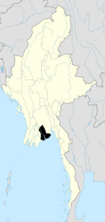
Kungyangon Township ( Burmese: ကွမ်းခြံကုန်း မြို့နယ် [kʊ́ɰ̃dʑàɰ̃ɡòʊɰ̃ mjo̰nɛ̀]) is a township of Yangon Region. It is located in the southwestern part of the Region, by the Andaman Sea.
- ^ Union Census Report. The 2014 Myanmar Population and Housing Census. Vol. 2. Naypyidaw: Ministry of Immigration and Population. May 2015. p. 62.


