
The area currently occupied by the U.S. State of New Mexico has undergone numerous changes in occupancy and territorial claims and designations. This geographic chronology traces the territorial evolution of New Mexico.
- Historical territorial claims of
Spain in the present
State of New Mexico:
- Nueva Vizcaya, 1562–1821
-
Santa Fe de Nuevo México, 1598–1821
- Treaty of Córdoba of 1821
- Historical territorial claims of
France in the present
State of New Mexico:
- Louisiane, 1682–1764
- Historical territorial claims of
Spain in the present
State of New Mexico:
-
Luisiana, 1764–1803
- Third Treaty of San Ildefonso of 1800
-
Luisiana, 1764–1803
- Historical territorial claims of
France in the present
State of New Mexico:
-
Louisiane, 1803
- Vente de la Louisiane of 1803
-
Louisiane, 1803
- Historical territorial claims of
Mexico in the present
State of New Mexico:
-
Santa Fé de Nuevo México, 1821–1848
- Treaty of Guadalupe Hidalgo of 1848
-
Santa Fé de Nuevo México, 1821–1848
- Historical territorial claims of the
Republic of Texas in the present
State of New Mexico:
- Disputed territory east of the
Rio Grande, 1836–1845
- Texas Annexation of 1845
- Disputed territory east of the
Rio Grande, 1836–1845
- Historical
political divisions of the United States in the present
State of New Mexico:
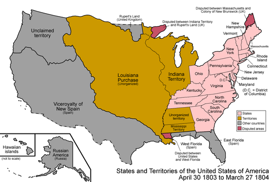
- Unorganized territory created by the Louisiana Purchase, 1803–1804
- District of Louisiana, 1804–1805
- Territory of Louisiana, 1805–1812
- Territory of Missouri, 1812–1821
-
Territory of Arkansaw, 1819–1836
- Adams–Onís Treaty of 1819
- Disputed territory created by the Texas Annexation, 1845–1850
-
Mexican–American War, 1846–1848
- U.S. Military Province of New Mexico, 1846
- U.S. Provisional Government of New Mexico 1846–1850
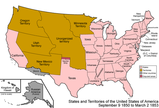
- Unorganized territory created by the Treaty of Guadalupe Hidalgo, 1848–1850
- State of Deseret (extralegal), 1849–1850
- Proposed state of New Mexico, 1850
-
Territory of New Mexico, 1850–1912
[1]
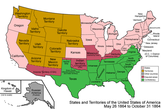
- Gadsden Purchase of 1853
-
American Civil War, 1861–1865
- Arizona Territory (CSA), 1861–1865
- State of New Mexico since 1912 [2] [3]
-
 An enlargeable map of the United States after the Constitution of the United States was ratified on March 4, 1789.
 -
 An enlargeable map of the United States after the secret Third Treaty of San Ildefonso transferred the Spanish colony of la Luisiana to the French Republic on October 1, 1800.
 -
 An enlargeable map of the United States after the Louisiana Purchase took effect on December 20,1803.
 -
 An enlargeable map of the United States after the creation of the District of Louisiana on March 26, 1804.
 -
 An enlargeable map of the United States after the creation of the Territory of Louisiana on March 3, 1805.
 -
 An enlargeable map of the United States after the creation of the Territory of Missouri on June 4, 1812.
 -
 An enlargeable map of the United States after the creation of the Territory of Arkansaw on March 2, 1819.
 -
 An enlargeable map of the United States after the Adams–Onís Treaty took effect on February 22, 1821.
 -
 Territorial claims of the Republic of Texas, May 2, 1836.
 -

-
 An enlargeable map of the United States after the Treaty of Guadalupe Hidalgo was signed on February 2, 1848.
 -
 An enlargeable map of the United States after the creation of the provisional State of Deseret on July 2, 1849.
 -
 An enlargeable map of the United States after the creation of the Territory of New Mexico and the Territory of Utah on September 9, 1850.
 -
 An enlargeable map of the United States after Gadsden Purchase on December 30, 1853.
 -
 An enlargeable map of the United States after the creation of the Territory of Colorado on February 28, 1861.
 -
 An enlargeable map of the United States after the creation of the Confederate Territory of Arizona on February 24, 1862.
 -
 An enlargeable map of the United States after the creation of the Territory of Arizona on June 19, 1862.
 -
 An enlargeable map of the United States after the admission of New Mexico to the Union on January 6, 1912.
 -


- History of New Mexico
- Indigenous peoples of the North American Southwest
- Territorial evolution of the United States
-
 Santa Fe de Nuevo México
 -
 La Louisiane
 -
La Luisiana
-
 Louisiana Purchase
 -
District of Louisiana
-
 Louisiana Territory
 -
 Arkansaw Territory
 -
Missouri Territory
-
 Mexican Empire
 -
 Republic of Texas
 -
U.S. provisional government of New Mexico
-
State of Deseret
-
 New Mexico Territory
 -
 Confederate Territory of Arizona
 -
State of New Mexico
- ^ Thirty-first United States Congress (September 9, 1850). "An Act Proposing to the State of Texas the Establishment of her Northern and Western Boundaries, the Relinquishment by the said State of all Territory claimed by her exterior to said Boundaries, and of all her Claims upon the United States, and to establish a territorial Government for New Mexico". Retrieved October 7, 2020.
- ^ Sixty-first United States Congress (June 20, 1910). "An Act To enable the people of New Mexico to form a constitution and state government and be admitted into the Union on an equal footing with the original States; and to enable the people of Arizona to form a constitution and state government and be admitted into the Union on an equal footing with the original States" (PDF). Library of Congress. Retrieved October 7, 2020.
- ^ William Howard Taft (January 6, 1912). "Proclamation 1175—Admitting New Mexico to the Union". The American Presidency Project. Retrieved October 7, 2020.
| By country | |
|---|---|
| By former country | |
| By subdivision |
|
| By region |
|
| By country, people, region or period | |
| By international organisation | |
The area currently occupied by the U.S. State of New Mexico has undergone numerous changes in occupancy and territorial claims and designations. This geographic chronology traces the territorial evolution of New Mexico.
- Historical territorial claims of
Spain in the present
State of New Mexico:
- Nueva Vizcaya, 1562–1821
-
Santa Fe de Nuevo México, 1598–1821
- Treaty of Córdoba of 1821
- Historical territorial claims of
France in the present
State of New Mexico:
- Louisiane, 1682–1764
- Historical territorial claims of
Spain in the present
State of New Mexico:
-
Luisiana, 1764–1803
- Third Treaty of San Ildefonso of 1800
-
Luisiana, 1764–1803
- Historical territorial claims of
France in the present
State of New Mexico:
-
Louisiane, 1803
- Vente de la Louisiane of 1803
-
Louisiane, 1803
- Historical territorial claims of
Mexico in the present
State of New Mexico:
-
Santa Fé de Nuevo México, 1821–1848
- Treaty of Guadalupe Hidalgo of 1848
-
Santa Fé de Nuevo México, 1821–1848
- Historical territorial claims of the
Republic of Texas in the present
State of New Mexico:
- Disputed territory east of the
Rio Grande, 1836–1845
- Texas Annexation of 1845
- Disputed territory east of the
Rio Grande, 1836–1845
- Historical
political divisions of the United States in the present
State of New Mexico:
- Unorganized territory created by the Louisiana Purchase, 1803–1804
- District of Louisiana, 1804–1805
- Territory of Louisiana, 1805–1812
- Territory of Missouri, 1812–1821
-
Territory of Arkansaw, 1819–1836
- Adams–Onís Treaty of 1819
- Disputed territory created by the Texas Annexation, 1845–1850
-
Mexican–American War, 1846–1848
- U.S. Military Province of New Mexico, 1846
- U.S. Provisional Government of New Mexico 1846–1850
- Unorganized territory created by the Treaty of Guadalupe Hidalgo, 1848–1850
- State of Deseret (extralegal), 1849–1850
- Proposed state of New Mexico, 1850
-
Territory of New Mexico, 1850–1912
[1]
- Gadsden Purchase of 1853
-
American Civil War, 1861–1865
- Arizona Territory (CSA), 1861–1865
- State of New Mexico since 1912 [2] [3]
-
An enlargeable map of the United States after the Constitution of the United States was ratified on March 4, 1789.
-
An enlargeable map of the United States after the secret Third Treaty of San Ildefonso transferred the Spanish colony of la Luisiana to the French Republic on October 1, 1800.
-
An enlargeable map of the United States after the Louisiana Purchase took effect on December 20,1803.
-
An enlargeable map of the United States after the creation of the District of Louisiana on March 26, 1804.
-
An enlargeable map of the United States after the creation of the Territory of Louisiana on March 3, 1805.
-
An enlargeable map of the United States after the creation of the Territory of Missouri on June 4, 1812.
-
An enlargeable map of the United States after the creation of the Territory of Arkansaw on March 2, 1819.
-
An enlargeable map of the United States after the Adams–Onís Treaty took effect on February 22, 1821.
-
Territorial claims of the Republic of Texas, May 2, 1836.
-
-
An enlargeable map of the United States after the Treaty of Guadalupe Hidalgo was signed on February 2, 1848.
-
An enlargeable map of the United States after the creation of the provisional State of Deseret on July 2, 1849.
-
An enlargeable map of the United States after the creation of the Territory of New Mexico and the Territory of Utah on September 9, 1850.
-
An enlargeable map of the United States after Gadsden Purchase on December 30, 1853.
-
An enlargeable map of the United States after the creation of the Territory of Colorado on February 28, 1861.
-
An enlargeable map of the United States after the creation of the Confederate Territory of Arizona on February 24, 1862.
-
An enlargeable map of the United States after the creation of the Territory of Arizona on June 19, 1862.
-
An enlargeable map of the United States after the admission of New Mexico to the Union on January 6, 1912.
-
- History of New Mexico
- Indigenous peoples of the North American Southwest
- Territorial evolution of the United States
-
Santa Fe de Nuevo México
-
La Louisiane
-
La Luisiana
-
Louisiana Purchase
-
District of Louisiana
-
Louisiana Territory
-
Arkansaw Territory
-
Missouri Territory
-
Mexican Empire
-
Republic of Texas
-
U.S. provisional government of New Mexico
-
State of Deseret
-
New Mexico Territory
-
Confederate Territory of Arizona
-
State of New Mexico
- ^ Thirty-first United States Congress (September 9, 1850). "An Act Proposing to the State of Texas the Establishment of her Northern and Western Boundaries, the Relinquishment by the said State of all Territory claimed by her exterior to said Boundaries, and of all her Claims upon the United States, and to establish a territorial Government for New Mexico". Retrieved October 7, 2020.
- ^ Sixty-first United States Congress (June 20, 1910). "An Act To enable the people of New Mexico to form a constitution and state government and be admitted into the Union on an equal footing with the original States; and to enable the people of Arizona to form a constitution and state government and be admitted into the Union on an equal footing with the original States" (PDF). Library of Congress. Retrieved October 7, 2020.
- ^ William Howard Taft (January 6, 1912). "Proclamation 1175—Admitting New Mexico to the Union". The American Presidency Project. Retrieved October 7, 2020.
| By country | |
|---|---|
| By former country | |
| By subdivision |
|
| By region |
|
| By country, people, region or period | |
| By international organisation | |