An enlargeable map of the United States after the
Constitution of the United States was ratified on March 4, 1789.An enlargeable map of the United States after the
Treaty of Córdoba was signed on August 24, 1821.An enlargeable map of the United States after the
Treaty of Guadalupe Hidalgo was signed on February 2, 1848.An enlargeable map of the United States after the creation of the proposed
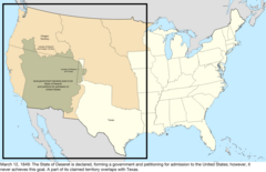
State of Deseret on July 2, 1849.An enlargeable map of the United States after the creation of the
Territory of New Mexico and the
Territory of Utah on September 9, 1850.An enlargeable map of the United States after
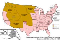
Gadsden Purchase on December 30, 1853.An enlargeable map of the United States after the creation of the
Territory of Colorado on February 28, 1861.An enlargeable map of the United States after the creation of the
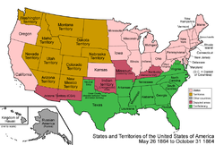
Confederate Territory of Arizona on February 24, 1862.An enlargeable map of the United States after the creation of the
Territory of Arizona on June 19, 1862.An enlargeable map of the United States after the annexation of northwestern Arizona on January 18, 1867.An enlargeable map of the United States after the admission of
Arizona to the
Union on February 14, 1912.An enlargeable map of the United States as it has been since
Hawaiiʻi was admitted to the
Union on August 21, 1959.
The following timeline traces the territorial evolution of the
U.S.State of Arizona.
^Decisions of the Department of the Interior in cases relating to the public lands: 1927–1954. United States. Department of the Interior. Washington. For sale by the Supt. of Docs., U.S. Govt. Print. Off. pp. 25, 337.
hdl:
2027/mdp.39015084910804.
An enlargeable map of the United States after the
Constitution of the United States was ratified on March 4, 1789.An enlargeable map of the United States after the
Treaty of Córdoba was signed on August 24, 1821.An enlargeable map of the United States after the
Treaty of Guadalupe Hidalgo was signed on February 2, 1848.An enlargeable map of the United States after the creation of the proposed
State of Deseret on July 2, 1849.An enlargeable map of the United States after the creation of the
Territory of New Mexico and the
Territory of Utah on September 9, 1850.An enlargeable map of the United States after
Gadsden Purchase on December 30, 1853.An enlargeable map of the United States after the creation of the
Territory of Colorado on February 28, 1861.An enlargeable map of the United States after the creation of the
Confederate Territory of Arizona on February 24, 1862.An enlargeable map of the United States after the creation of the
Territory of Arizona on June 19, 1862.An enlargeable map of the United States after the annexation of northwestern Arizona on January 18, 1867.An enlargeable map of the United States after the admission of
Arizona to the
Union on February 14, 1912.An enlargeable map of the United States as it has been since
Hawaiiʻi was admitted to the
Union on August 21, 1959.
The following timeline traces the territorial evolution of the
U.S.State of Arizona.
^Decisions of the Department of the Interior in cases relating to the public lands: 1927–1954. United States. Department of the Interior. Washington. For sale by the Supt. of Docs., U.S. Govt. Print. Off. pp. 25, 337.
hdl:
2027/mdp.39015084910804.


 Territorial evolution of California
 List of territorial claims and designations in Colorado
 Territorial evolution of Nevada
 Territorial evolution of New Mexico
 Territorial evolution of Utah