| This is the
talk page for discussing
Treaty of Sèvres and anything related to its purposes and tasks. This is not a forum for general discussion of the article's subject. |
Article policies
|
| Find sources: Google ( books · news · scholar · free images · WP refs) · FENS · JSTOR · TWL |
|
Archives:
1Auto-archiving period: 360 days
|
|
| A fact from this article was featured on Wikipedia's Main Page in the On this day section on August 10, 2005, August 10, 2006, and August 10, 2007. |
|
| This article is rated C-class on Wikipedia's
content assessment scale. It is of interest to the following WikiProjects: | |||||||||||||||||||||||||||||||||||||||||||||||||||||||||||||||||||||||||||||||||
| ||||||||||||||||||||||||||||||||||||||||||||||||||||||||||||||||||||||||||||||||||


.svg)


 | This article may be within the scope of Greek and Turkish wikipedians cooperation board. Please see the project page for more details, to request intervention on the notification board or peruse other tasks. |
I would be ready to add under the footnote a short timeline of notable develoments during the 10-month period between the Armistice of Mudros ( 30 October 1918; the agreement that ended the war for the Ottoman Empire, and which should be mentioned here) and the Treaty of Sevres. I do not know if there are any examples of such a timeline in other articles on international treaties but it would certainly be useful. I can write it in smaller characters like the footnote, therefore the main body of the article would still jump first to the eye. Cretanforever

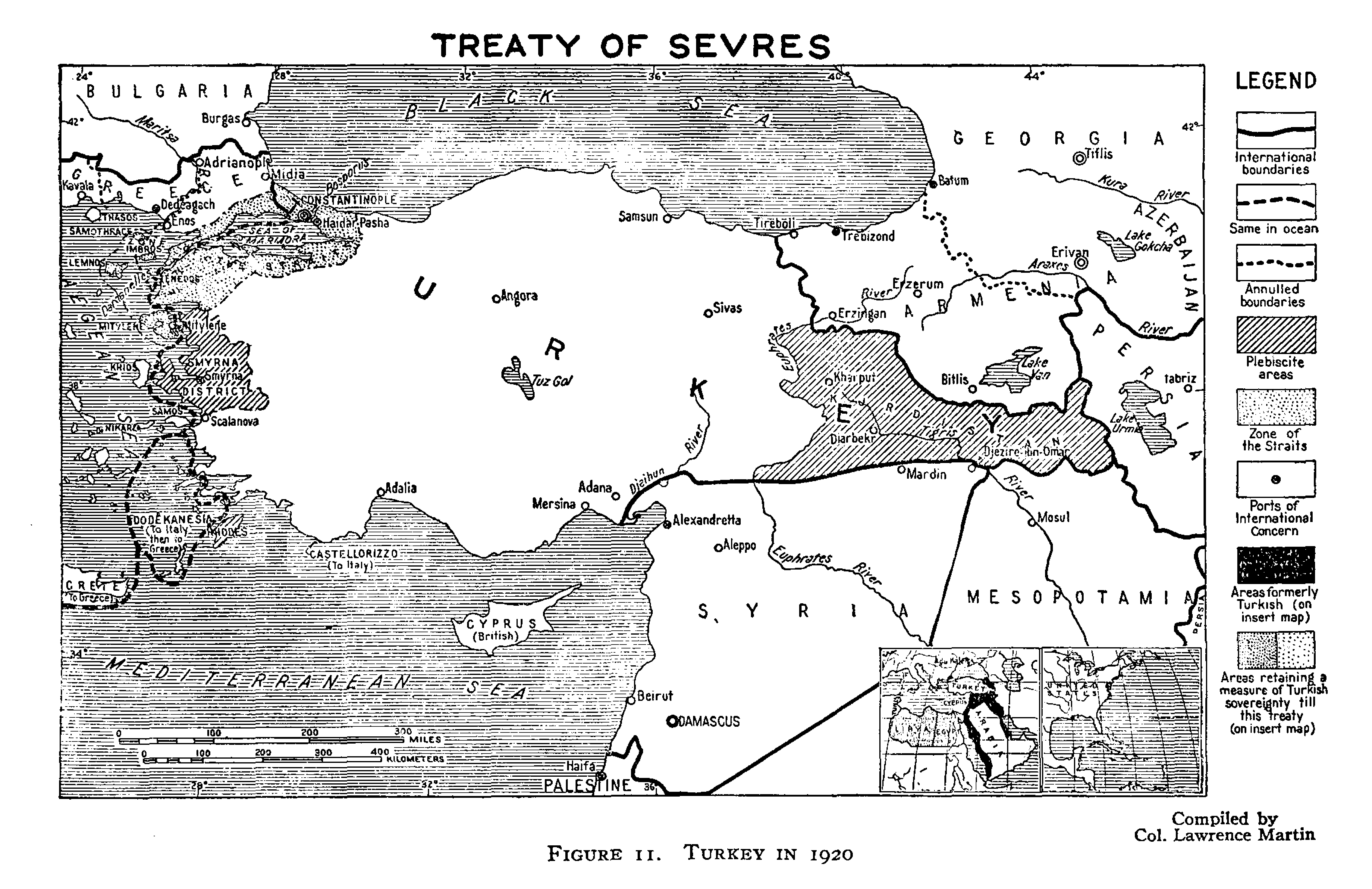
Problems with the map
- It doesn't show that Turkey "recognized occupation of Antalya and its hinterlands" by Italians (p. 61).
- Straits were to be controlled by an international commission (p. 61) but here it is just defined as "Zone of the Straits" instead of the "international zone" as seen in other maps (for example see the map in Atatürk in Nazi Imagination by Stefan Ihrig, p. 21).
- This is something that I did not see in other maps too but indeed Greece recieved "the entire southwest" of Turkey (p. 61).
- Source: Erickson, Edward J. The Turkish War of Independence: a Military History, 1919-1923.
-- V. E. ( talk) 03:08, 6 August 2021 (UTC)
- The full text of the treaty is at
https://wwi.lib.byu.edu/index.php/Peace_Treaty_of_Sèvres . I don't believe it allows Italian occupation of any of the Anatolian mainland, but only some islands. Antalya (aka Adalia) is not mentioned. The "Zone of the Straits" is called that on the map because it is called that in the treaty (however our article needs to expanded regarding that region). "Izmir and the entire southwest" is an inaccurate reference to the Smyrna District which is defined very precisely as the region shown on our maps. Nor was Greece merely "given" it, see the treaty for the correct more complicated story.
Zero
talk
06:53, 6 August 2021 (UTC)
- This way, you are interpreting the treaty, a primary source, yourself. Our content should be based on secondary sources, or else it causes
WP:OR such as in this case. Furthermore, your interpretation of the treaty conflicts with what a reliable, secondary source states.--
V. E. (
talk)
07:36, 6 August 2021 (UTC)
- I consulted multiple reliable secondary sources. The maps I based this one on were not part of the treaty but were drawn by independent experts. Besides that, when we can see that a secondary source is manifestly false we should look for better sources, not argue that the incorrect information must be added. Every major event in modern history is covered by lots of sources and almost always there are disagreements. Our task is to survey the sources to resolve the disagreements towards the truth.
Zero
talk
10:12, 6 August 2021 (UTC)
- If there are other sources than the ones on this talk page, where did you cite these them? If not, what makes you think these sources are better? Also how do you see that the "source is manifestly false"? Is it because it doesn't align with your interpretation of the Treaty or because it conflicts with other secondary, reliable sources?-- V. E. ( talk) 10:45, 6 August 2021 (UTC)
- For example Temuçin Ertan states that according to the Treaty of Serves, Antalya and Konya would be under Italian zone of influence (p. 31).-- V. E. ( talk) 11:12, 6 August 2021 (UTC)
- According to Cemal Kemal, the region from Edremit to the verge of Clicia, including Antalya, would be ceded to Italy per Treaty of Serves (
p. 666).--
V. E. (
talk)
11:28, 6 August 2021 (UTC)
- I'm not going to read sources in Turkish. And I'm also not going to attribute anything to the treaty that is not in the treaty. There is also no policy against use of primary sources. Here you are confusing two different things: "ceded" is a contradiction to "zone of influence", not a confirmation. The "zones of influence" are not in the Treaty of Sevrès but in "Tripartite Agreement between the British Empire, France and Italy respecting Anatolia" that Turkey did not sign. These three powers agreed to divide up the economic spoils on the pretext of helping Turkey. It was typical imperialist bullshit, but it did not challenge Turkish sovereignty.
Zero
talk
12:41, 6 August 2021 (UTC)
- Indeed, especially the "imperialist bullshit" part:)
Selfstudier (
talk)
12:46, 6 August 2021 (UTC)
- Whoa, you objected to lots of things that I did not even say. For example, I did not say anything about "Turkish sovereignty" or "imperialism". I did not know the technical uncorrelation between ceded and zone of influence because I'm not a native speaker, and ceded was not placed in quotes by the way. I asked you what makes you think your sources are "better" and more accurate. Besides, WP:NOR prohibits interpreting primary sources and here you are preparing a map on your interpretation of the Treaty of Serves. Furthermore your interpretation and the interpretation of reliable sources I cited differ. The last but not the least, not all of the sources I cited are in Turkish, Erickson's book is written in English, and even so citing sources in Turkish isn't prohibited.-- V. E. ( talk) 13:40, 6 August 2021 (UTC)
- Kia Mehrdad ( 2017, p. 48) "Southwestern Anatolia was designated as the sphere of influence of Italy". (quoted directly from Treaty of Serves section)-- V. E. ( talk) 14:08, 6 August 2021 (UTC)
- Ronald G. Suny (2015), the map in the page 341 displays zones of influences for Italy and France on the Treaty of Serves map. (Book title: They Can Live in the Desert but Nowhere Else).--
V. E. (
talk)
14:16, 6 August 2021 (UTC)
- Mehrdad is an encyclopedia, your quote is from the entry for Sevres. Are you saying that the "sphere of influence" signified Italian control over a geographical area? What do you think "sphere of influence" means in this case? Be specific. Have you read the Toynbee source I posted above? (My understanding of the situation is that it didn't mean very much at all but if you have sources that say otherwise I would like to see them).
Selfstudier (
talk)
14:30, 6 August 2021 (UTC)
- Firstly, an encyclopedia is a WP:TETRIARY whose usage is not prohibited on Wikipedia. So, I can see nothing wrong with using it. Secondly, I did not read in any reliable sources on the subject that sphere of influence did not signify "Italian control over a geographical area". My thoughts on the definition of "sphere of influence" is irrelevant because I am no subject expert. However, looking at the reliable sources, they label spheres of influences on the map. If I am not mistaken Toynbee source is published in 1922, and I would advise against using that because WP:AGEMATTERS as older sources may be inaccurate. We should stick to up-to-date sources. Lastly, I have already shared 5 sources in this discussion (3 of them being text definitions, 2 of them being maps [Ihrig and Suny]), and I will continue to share new sources as I find. Best regards -- V. E. ( talk) 15:08, 6 August 2021 (UTC)
- Mehrdad is an encyclopedia, your quote is from the entry for Sevres. Are you saying that the "sphere of influence" signified Italian control over a geographical area? What do you think "sphere of influence" means in this case? Be specific. Have you read the Toynbee source I posted above? (My understanding of the situation is that it didn't mean very much at all but if you have sources that say otherwise I would like to see them).
Selfstudier (
talk)
14:30, 6 August 2021 (UTC)
- Indeed, especially the "imperialist bullshit" part:)
Selfstudier (
talk)
12:46, 6 August 2021 (UTC)
- I'm not going to read sources in Turkish. And I'm also not going to attribute anything to the treaty that is not in the treaty. There is also no policy against use of primary sources. Here you are confusing two different things: "ceded" is a contradiction to "zone of influence", not a confirmation. The "zones of influence" are not in the Treaty of Sevrès but in "Tripartite Agreement between the British Empire, France and Italy respecting Anatolia" that Turkey did not sign. These three powers agreed to divide up the economic spoils on the pretext of helping Turkey. It was typical imperialist bullshit, but it did not challenge Turkish sovereignty.
Zero
talk
12:41, 6 August 2021 (UTC)
- I consulted multiple reliable secondary sources. The maps I based this one on were not part of the treaty but were drawn by independent experts. Besides that, when we can see that a secondary source is manifestly false we should look for better sources, not argue that the incorrect information must be added. Every major event in modern history is covered by lots of sources and almost always there are disagreements. Our task is to survey the sources to resolve the disagreements towards the truth.
Zero
talk
10:12, 6 August 2021 (UTC)
- This way, you are interpreting the treaty, a primary source, yourself. Our content should be based on secondary sources, or else it causes
WP:OR such as in this case. Furthermore, your interpretation of the treaty conflicts with what a reliable, secondary source states.--
V. E. (
talk)
07:36, 6 August 2021 (UTC)
- The full text of the treaty is at
https://wwi.lib.byu.edu/index.php/Peace_Treaty_of_Sèvres . I don't believe it allows Italian occupation of any of the Anatolian mainland, but only some islands. Antalya (aka Adalia) is not mentioned. The "Zone of the Straits" is called that on the map because it is called that in the treaty (however our article needs to expanded regarding that region). "Izmir and the entire southwest" is an inaccurate reference to the Smyrna District which is defined very precisely as the region shown on our maps. Nor was Greece merely "given" it, see the treaty for the correct more complicated story.
Zero
talk
06:53, 6 August 2021 (UTC)
V.E.: "you are preparing a map on your interpretation of the Treaty of Serves" — I've already told you that's not true. My main source was this map prepared by the American geographer Lawrence Martin for the Carnegie Endowment for International Peace. Compared to your maps, it has the advantage of matching the text of the treaty. It is also easy to find lots of published maps that agree with it, for example here. Dealing with sources that disagree is part of the job of being a Wikipedia editor and are allowed to look at the primary source to see which secondary sources have a better case for citation. The bottom line is that if it isn't in the treaty it isn't in the treaty. That's not interpretation but just reading, which is perfectly within the rules. Zero talk 14:56, 6 August 2021 (UTC)
- The problem here as I see it is not being cognizant of what the treaties actually stipulate, just saying "sphere of influence" without specifying what that means is useless. Bringing maps additional to those already matched to the treaty is useless. It is true we are missing a section in the article about the tripartite treaty and I provided some sources for that above. By all means bring more. It seems to me that if that was done then some of this argument might evaporate.
Selfstudier (
talk)
15:16, 6 August 2021 (UTC)
- Zero: I think the problem with the maps you cited is that they are published in the years 1924 and 1922 (if I did not find it wrong on the web). We should stick to more recent sources, such as the ones I cited, per
WP:AGEMATTERS. Selfstudier: Maybe there is something you are missing or can't see when reading the peace treaty but multiple academic historians can. "'sphere of influence' without specifying what that means is useless" Suny and Ihrig doesn't seem to agree with you on that either as they clearly label it on their maps. Lastly, we are not here to
WP:RIGHTGREATWRONGS, the related text from the page: "we can only report that which is verifiable from reliable and secondary sources, giving appropriate weight to the balance of informed opinion". So, we shouldn't be dismissing other half of the reliable sources just because we can't find something they said in the treaty. Maybe it is there but we can't see or understand it, or it isn't but this isn't our mission to correct it. (Sorry, edit conflict. I was going to paste this here. I will post it as it is without changing it and answer your next post seperately)--
V. E. (
talk)
15:34, 6 August 2021 (UTC)
- New maps are just as capable of being wrong as old maps, in this case I prefer the maps actually identified with the treaty. You need to convince me (and I think Zero as well) that your "new" maps are somehow better. Labelling a map "sphere of influence" without explaining what it means is worthless (Oh, I already said that, ah well).
Selfstudier (
talk)
15:42, 6 August 2021 (UTC)
- Everyone is capable of being wrong but we should use more recent sources per
WP:AGEMATTERS "older sources may be inaccurate because new information has been brought to light, new theories proposed, or vocabulary changed". Also it being "worthless" is your interpretation, as academicians label it, it is safe to assume that it is worth.--
V. E. (
talk)
15:49, 6 August 2021 (UTC)
- The key word there is "may". I'll rephrase the other, I want an explanation of what "sphere of influence" means on the map. (look at out Sykes Picot article where the phrase is clearly explained in that context).
Selfstudier (
talk)
15:53, 6 August 2021 (UTC)
- If you know very well what it means, why don't you post it here with sources? I don't need to give you an explanation for that. I'm only conveying what reliable sources state.--
V. E. (
talk)
15:58, 6 August 2021 (UTC)
- See my response at the bottom. Selfstudier ( talk) 16:07, 6 August 2021 (UTC)
- If you know very well what it means, why don't you post it here with sources? I don't need to give you an explanation for that. I'm only conveying what reliable sources state.--
V. E. (
talk)
15:58, 6 August 2021 (UTC)
- The key word there is "may". I'll rephrase the other, I want an explanation of what "sphere of influence" means on the map. (look at out Sykes Picot article where the phrase is clearly explained in that context).
Selfstudier (
talk)
15:53, 6 August 2021 (UTC)
- Everyone is capable of being wrong but we should use more recent sources per
WP:AGEMATTERS "older sources may be inaccurate because new information has been brought to light, new theories proposed, or vocabulary changed". Also it being "worthless" is your interpretation, as academicians label it, it is safe to assume that it is worth.--
V. E. (
talk)
15:49, 6 August 2021 (UTC)
- New maps are just as capable of being wrong as old maps, in this case I prefer the maps actually identified with the treaty. You need to convince me (and I think Zero as well) that your "new" maps are somehow better. Labelling a map "sphere of influence" without explaining what it means is worthless (Oh, I already said that, ah well).
Selfstudier (
talk)
15:42, 6 August 2021 (UTC)
- Zero: I think the problem with the maps you cited is that they are published in the years 1924 and 1922 (if I did not find it wrong on the web). We should stick to more recent sources, such as the ones I cited, per
WP:AGEMATTERS. Selfstudier: Maybe there is something you are missing or can't see when reading the peace treaty but multiple academic historians can. "'sphere of influence' without specifying what that means is useless" Suny and Ihrig doesn't seem to agree with you on that either as they clearly label it on their maps. Lastly, we are not here to
WP:RIGHTGREATWRONGS, the related text from the page: "we can only report that which is verifiable from reliable and secondary sources, giving appropriate weight to the balance of informed opinion". So, we shouldn't be dismissing other half of the reliable sources just because we can't find something they said in the treaty. Maybe it is there but we can't see or understand it, or it isn't but this isn't our mission to correct it. (Sorry, edit conflict. I was going to paste this here. I will post it as it is without changing it and answer your next post seperately)--
V. E. (
talk)
15:34, 6 August 2021 (UTC)
This article displays maps for a sequence of treaties and secret understandings related to this question. It is not the best source available but it shows the complexity of the situation and how many non-specialist sources are able to get confused. (If the article is pay-walled to you, send me mail and I'll provide a copy). Zero talk 15:19, 6 August 2021 (UTC)
- ) Yes, once the Russians let the cat out of the bag, the conspiracy theorists had a field day, with some justification even if they made a bit too much of a meal out of it.
Selfstudier (
talk)
15:28, 6 August 2021 (UTC)
- Zero: If all of it is 9 pages, yes, I can access it for now. Other than that, please cite with pages and quotations, and also please explain that how it show that "many non-specialist sources are able to get confused" and how do you define "non-specialists" and I think it might also be subject to
WP:AGEMATTERS as it was published in 1921, if I am not mistaken.--
V. E. (
talk)
15:41, 6 August 2021 (UTC)
- Merely because a source is old does not mean it cannot be used or that it is invalid so repeating agematters ad nauseum is also pointless.
Selfstudier (
talk)
15:44, 6 August 2021 (UTC)
- If it was "merely", yes, but if a source is old and conflicts with newer sources such as in this case, that is concerning.--
V. E. (
talk)
15:51, 6 August 2021 (UTC)
- What I am trying to explain is that there may not be a conflict, it is your interpretation that a map with an area labelled sphere of influence is a contradiction to what we have now. But that is not necessarily the case and you have certainly not demonstrated it to my satisfaction.
Selfstudier (
talk)
15:57, 6 August 2021 (UTC)
- It is not my "interpretation" because I'm referencing you to the maps on two different secondary sources. It is an interpretation of the academicians not mine.--
V. E. (
talk)
16:02, 6 August 2021 (UTC)
- OK, we are now going in circles, you are insisting on your position and claiming that your sources support your position. I dispute your position. It is you who wishes to disturb an existing consensus, you may initiate a formal dispute resolution process, an RFC, and see whether you can gain consensus for your position among other editors besides myself.
Selfstudier (
talk)
16:05, 6 August 2021 (UTC)
- Thanks, although I do not agree with your points, I think it was mostly a clear debate.-- V. E. ( talk) 16:07, 6 August 2021 (UTC)
- @ Selfstudier:, just one question. If I start an RfC, should I assume that you recognize that Italy had a zone of influence on Antalya based on the sources I cited or do you still reject it based on the Treaty itself. If you do not deny it, I will eliminate one option for RfC. Thank you.-- V. E. ( talk) 16:12, 6 August 2021 (UTC)
- OK, we are now going in circles, you are insisting on your position and claiming that your sources support your position. I dispute your position. It is you who wishes to disturb an existing consensus, you may initiate a formal dispute resolution process, an RFC, and see whether you can gain consensus for your position among other editors besides myself.
Selfstudier (
talk)
16:05, 6 August 2021 (UTC)
- It is not my "interpretation" because I'm referencing you to the maps on two different secondary sources. It is an interpretation of the academicians not mine.--
V. E. (
talk)
16:02, 6 August 2021 (UTC)
- What I am trying to explain is that there may not be a conflict, it is your interpretation that a map with an area labelled sphere of influence is a contradiction to what we have now. But that is not necessarily the case and you have certainly not demonstrated it to my satisfaction.
Selfstudier (
talk)
15:57, 6 August 2021 (UTC)
- If it was "merely", yes, but if a source is old and conflicts with newer sources such as in this case, that is concerning.--
V. E. (
talk)
15:51, 6 August 2021 (UTC)
- Merely because a source is old does not mean it cannot be used or that it is invalid so repeating agematters ad nauseum is also pointless.
Selfstudier (
talk)
15:44, 6 August 2021 (UTC)
- Zero: If all of it is 9 pages, yes, I can access it for now. Other than that, please cite with pages and quotations, and also please explain that how it show that "many non-specialist sources are able to get confused" and how do you define "non-specialists" and I think it might also be subject to
WP:AGEMATTERS as it was published in 1921, if I am not mistaken.--
V. E. (
talk)
15:41, 6 August 2021 (UTC)
- ) Yes, once the Russians let the cat out of the bag, the conspiracy theorists had a field day, with some justification even if they made a bit too much of a meal out of it.
Selfstudier (
talk)
15:28, 6 August 2021 (UTC)
Apparently the UK copy of the treaty has maps: "British Treaty Series, No. 11, 1920, Cmd. 964" and similarly for the Tripartite Agreement: "British Treaty Series, No. 12, 1920, Cmd. 963". I didn't manage to find online copies of these but I can probably find them in hardcopy. Zero talk 16:19, 6 August 2021 (UTC)
- Zero: Would you like to discuss it further or should I go for an RfC? (but I feel like we discussed everything).--
V. E. (
talk)
16:25, 6 August 2021 (UTC)
- The Cambridge History of Turkey, Vol 4, p130: "
The Sèvres document proposed dividing eastern Anatolia between an independent Armenia and an autonomous Kurdistan, while it gave to Greece the Aegean islands and Eastern Thrace up to the outskirts of Istanbul. Izmir and its hinterland were also placed under Greek administration as a prelude to formal annexation, to be based on a plebiscite, within five years. Simultaneously, Britain, France and Italy signed a tripartite agreement confirming the Italian sphere of influence in south-western Anatolia and a French zone conforming to wartime agreements in the Eastern Mediterranean and to the north of the new Syria mandate.
" This is a correct summary of what the two agreements say and it is what Selfstudier and I have been saying. The "zones of influence" are not in the Treaty of Sèvres but in the Tripartite Agreement. Start an RfC if you like, but I have no sympathy for your position. Zero talk 16:39, 6 August 2021 (UTC)- In answer to the question of whether there were spheres of influence, the Toynbee source I pointed you to confirms that there were. What I am disputing with you specifically is whether it is appropriate to display them on a map in such a way as to suggest a control over the geography (movement of goods and people etc) or without any explanation of what such a zone entailed. Possibly we could add explanatory commentary below the map about these spheres. But I still have a suggestion, the article is clearly deficient in this area (maps aside), why don't you have a go at fixing up the article first?
Selfstudier (
talk)
17:24, 6 August 2021 (UTC)
- Zero: The Turkish War of Independence: a Military History, p. 61
"The treaty reconfirmed the Arbitration Award of February 1914, which recognized Greek sovereignty of the Aegean islands and Italian possession of the Dodecanese islands, along with the occupation of Antalya and its hinterlands."
Reading two sources, what I understand is there is also a tripartite agreement seperate from the Treaty of Serves as the book you cited states but what I see in this passage is that with the Serves, Ottomans recognized an earlier treaty which enabled Italy to invade Antalya. What do you think about this?
- Zero: The Turkish War of Independence: a Military History, p. 61
- In answer to the question of whether there were spheres of influence, the Toynbee source I pointed you to confirms that there were. What I am disputing with you specifically is whether it is appropriate to display them on a map in such a way as to suggest a control over the geography (movement of goods and people etc) or without any explanation of what such a zone entailed. Possibly we could add explanatory commentary below the map about these spheres. But I still have a suggestion, the article is clearly deficient in this area (maps aside), why don't you have a go at fixing up the article first?
Selfstudier (
talk)
17:24, 6 August 2021 (UTC)
- The Cambridge History of Turkey, Vol 4, p130: "
- Selfstudier: I have found a definition for "zone of influence" but it is kinda vauge. I will surely share it later but not today. Improving the article is a good idea, I agree on that.--
V. E. (
talk)
17:30, 6 August 2021 (UTC)
- Our article should have a section on the Tripartite Agreement with a map showing the zones of influence. Since those zones are not specified in the Treaty of Peace, they shouldn't be shown in that map (and the map is already crowded enough). The main treaty, by the way, refers to complete withdrawal of Allied forces but also refers to the expenses of maintaining occupying forces. There is no clause requiring Allied withdrawal by a particular date, but also no clause giving permission for indefinite occupation. That issue is in the Tripartite Agreement: "
The French and Italian Governments will withdraw their troops from the respective areas where their special interests are recognized when the contracting Powers are agreed in considering that the said Treaty of Peace is being executed and that the measures accepted by Turkey for the protection of Christian minorities have been put into force and their execution effectively guaranteed.
" Zero talk 03:11, 7 August 2021 (UTC)- Hi, I have checked one or two more sources that also state that there was a seperate agreement between Britain France and Italy but the point is the source including the one you cited mention the tripartite agreement along with Treaty of Serves; and I couldn't find a map that shows the ZoI for tripartite agreement alone. So, I think we need a map (seperate to yours) that shows both ZoI and ceded territory like the ones of Ihrig and Suny.--
V. E. (
talk)
07:07, 7 August 2021 (UTC)
- p 124 of https://www.jstor.org/stable/208207?seq=1#metadata_info_tab_contents has a map that might help. Selfstudier ( talk) 09:00, 7 August 2021 (UTC)
- p 186-9 of Mapping the Middle East by Zayde Antrim is worth a read (discusses Martin's de-emphasis of European interests) Selfstudier ( talk) 10:18, 7 August 2021 (UTC)
- Malcolm Yapp (9 January 2014). The Making of the Modern Near East 1792-1923. Taylor & Francis. pp. 376–. ISBN 978-1-317-87106-4. Selfstudier ( talk) 10:24, 7 August 2021 (UTC)
- Hi, I have checked one or two more sources that also state that there was a seperate agreement between Britain France and Italy but the point is the source including the one you cited mention the tripartite agreement along with Treaty of Serves; and I couldn't find a map that shows the ZoI for tripartite agreement alone. So, I think we need a map (seperate to yours) that shows both ZoI and ceded territory like the ones of Ihrig and Suny.--
V. E. (
talk)
07:07, 7 August 2021 (UTC)
- Our article should have a section on the Tripartite Agreement with a map showing the zones of influence. Since those zones are not specified in the Treaty of Peace, they shouldn't be shown in that map (and the map is already crowded enough). The main treaty, by the way, refers to complete withdrawal of Allied forces but also refers to the expenses of maintaining occupying forces. There is no clause requiring Allied withdrawal by a particular date, but also no clause giving permission for indefinite occupation. That issue is in the Tripartite Agreement: "
- Selfstudier: I have found a definition for "zone of influence" but it is kinda vauge. I will surely share it later but not today. Improving the article is a good idea, I agree on that.--
V. E. (
talk)
17:30, 6 August 2021 (UTC)
I will make a map based on this one that SelfStudier found and put it here for discussion. I will also see if I can find the two command papers that I mentioned above. Zero talk 12:24, 8 August 2021 (UTC)
Ahah! The Tripartite Agreement actually came with a map and refers to it. Here it is. Zero talk 14:15, 8 August 2021 (UTC)
- Outstanding! That and a proper write up in the article should take care of things. Selfstudier ( talk) 15:46, 8 August 2021 (UTC)

Today I visited Command Paper 963 and found a large color map almost one meter wide. I couldn't manage to photocopy it in pieces due to the very heavy volume it was bound into. The crappy version here is made by joining some photos taken with my phone. I will create a simple version for the article. Zero talk 11:24, 9 August 2021 (UTC)
- I have done this. What do you think?-- V. E. ( talk) 15:52, 9 August 2021 (UTC)
Which was a clearer map, it seems to have been changed by an user who no longer exists. And now there are bunch of unclear, amateur maps added, and according to talk page they are wrong and they need a new map. Why not use the original?
- Please remember to sign your posts (4 ~'s). Which map are you referring to as the original map? Which user has disappeared and when did they change it? Which unclear amateur maps are you referring to? Selfstudier ( talk) 11:51, 6 September 2021 (UTC)
- Selected anniversaries (August 2005)
- Selected anniversaries (August 2006)
- Selected anniversaries (August 2007)
- C-Class military history articles
- C-Class Ottoman military history articles
- Ottoman military history task force articles
- C-Class World War I articles
- World War I task force articles
- C-Class Armenian articles
- Unknown-importance Armenian articles
- WikiProject Armenia articles
- C-Class Greek articles
- Mid-importance Greek articles
- WikiProject Greece general articles
- All WikiProject Greece pages
- C-Class Palestine-related articles
- Mid-importance Palestine-related articles
- WikiProject Palestine articles
- C-Class Turkey articles
- Mid-importance Turkey articles
- All WikiProject Turkey pages
- C-Class Kurdistan articles
- Mid-importance Kurdistan articles
- WikiProject Kurdistan articles
- Greek and Turkish wikipedians cooperation board
| This is the
talk page for discussing
Treaty of Sèvres and anything related to its purposes and tasks. This is not a forum for general discussion of the article's subject. |
Article policies
|
| Find sources: Google ( books · news · scholar · free images · WP refs) · FENS · JSTOR · TWL |
|
Archives:
1Auto-archiving period: 360 days
|
|
| A fact from this article was featured on Wikipedia's Main Page in the On this day section on August 10, 2005, August 10, 2006, and August 10, 2007. |
|
| This article is rated C-class on Wikipedia's
content assessment scale. It is of interest to the following WikiProjects: | |||||||||||||||||||||||||||||||||||||||||||||||||||||||||||||||||||||||||||||||||
| ||||||||||||||||||||||||||||||||||||||||||||||||||||||||||||||||||||||||||||||||||
| This article may be within the scope of Greek and Turkish wikipedians cooperation board. Please see the project page for more details, to request intervention on the notification board or peruse other tasks. |
I would be ready to add under the footnote a short timeline of notable develoments during the 10-month period between the Armistice of Mudros ( 30 October 1918; the agreement that ended the war for the Ottoman Empire, and which should be mentioned here) and the Treaty of Sevres. I do not know if there are any examples of such a timeline in other articles on international treaties but it would certainly be useful. I can write it in smaller characters like the footnote, therefore the main body of the article would still jump first to the eye. Cretanforever
Problems with the map
- It doesn't show that Turkey "recognized occupation of Antalya and its hinterlands" by Italians (p. 61).
- Straits were to be controlled by an international commission (p. 61) but here it is just defined as "Zone of the Straits" instead of the "international zone" as seen in other maps (for example see the map in Atatürk in Nazi Imagination by Stefan Ihrig, p. 21).
- This is something that I did not see in other maps too but indeed Greece recieved "the entire southwest" of Turkey (p. 61).
- Source: Erickson, Edward J. The Turkish War of Independence: a Military History, 1919-1923.
-- V. E. ( talk) 03:08, 6 August 2021 (UTC)
- The full text of the treaty is at
https://wwi.lib.byu.edu/index.php/Peace_Treaty_of_Sèvres . I don't believe it allows Italian occupation of any of the Anatolian mainland, but only some islands. Antalya (aka Adalia) is not mentioned. The "Zone of the Straits" is called that on the map because it is called that in the treaty (however our article needs to expanded regarding that region). "Izmir and the entire southwest" is an inaccurate reference to the Smyrna District which is defined very precisely as the region shown on our maps. Nor was Greece merely "given" it, see the treaty for the correct more complicated story.
Zero
talk
06:53, 6 August 2021 (UTC)
- This way, you are interpreting the treaty, a primary source, yourself. Our content should be based on secondary sources, or else it causes
WP:OR such as in this case. Furthermore, your interpretation of the treaty conflicts with what a reliable, secondary source states.--
V. E. (
talk)
07:36, 6 August 2021 (UTC)
- I consulted multiple reliable secondary sources. The maps I based this one on were not part of the treaty but were drawn by independent experts. Besides that, when we can see that a secondary source is manifestly false we should look for better sources, not argue that the incorrect information must be added. Every major event in modern history is covered by lots of sources and almost always there are disagreements. Our task is to survey the sources to resolve the disagreements towards the truth.
Zero
talk
10:12, 6 August 2021 (UTC)
- If there are other sources than the ones on this talk page, where did you cite these them? If not, what makes you think these sources are better? Also how do you see that the "source is manifestly false"? Is it because it doesn't align with your interpretation of the Treaty or because it conflicts with other secondary, reliable sources?-- V. E. ( talk) 10:45, 6 August 2021 (UTC)
- For example Temuçin Ertan states that according to the Treaty of Serves, Antalya and Konya would be under Italian zone of influence (p. 31).-- V. E. ( talk) 11:12, 6 August 2021 (UTC)
- According to Cemal Kemal, the region from Edremit to the verge of Clicia, including Antalya, would be ceded to Italy per Treaty of Serves (
p. 666).--
V. E. (
talk)
11:28, 6 August 2021 (UTC)
- I'm not going to read sources in Turkish. And I'm also not going to attribute anything to the treaty that is not in the treaty. There is also no policy against use of primary sources. Here you are confusing two different things: "ceded" is a contradiction to "zone of influence", not a confirmation. The "zones of influence" are not in the Treaty of Sevrès but in "Tripartite Agreement between the British Empire, France and Italy respecting Anatolia" that Turkey did not sign. These three powers agreed to divide up the economic spoils on the pretext of helping Turkey. It was typical imperialist bullshit, but it did not challenge Turkish sovereignty.
Zero
talk
12:41, 6 August 2021 (UTC)
- Indeed, especially the "imperialist bullshit" part:)
Selfstudier (
talk)
12:46, 6 August 2021 (UTC)
- Whoa, you objected to lots of things that I did not even say. For example, I did not say anything about "Turkish sovereignty" or "imperialism". I did not know the technical uncorrelation between ceded and zone of influence because I'm not a native speaker, and ceded was not placed in quotes by the way. I asked you what makes you think your sources are "better" and more accurate. Besides, WP:NOR prohibits interpreting primary sources and here you are preparing a map on your interpretation of the Treaty of Serves. Furthermore your interpretation and the interpretation of reliable sources I cited differ. The last but not the least, not all of the sources I cited are in Turkish, Erickson's book is written in English, and even so citing sources in Turkish isn't prohibited.-- V. E. ( talk) 13:40, 6 August 2021 (UTC)
- Kia Mehrdad ( 2017, p. 48) "Southwestern Anatolia was designated as the sphere of influence of Italy". (quoted directly from Treaty of Serves section)-- V. E. ( talk) 14:08, 6 August 2021 (UTC)
- Ronald G. Suny (2015), the map in the page 341 displays zones of influences for Italy and France on the Treaty of Serves map. (Book title: They Can Live in the Desert but Nowhere Else).--
V. E. (
talk)
14:16, 6 August 2021 (UTC)
- Mehrdad is an encyclopedia, your quote is from the entry for Sevres. Are you saying that the "sphere of influence" signified Italian control over a geographical area? What do you think "sphere of influence" means in this case? Be specific. Have you read the Toynbee source I posted above? (My understanding of the situation is that it didn't mean very much at all but if you have sources that say otherwise I would like to see them).
Selfstudier (
talk)
14:30, 6 August 2021 (UTC)
- Firstly, an encyclopedia is a WP:TETRIARY whose usage is not prohibited on Wikipedia. So, I can see nothing wrong with using it. Secondly, I did not read in any reliable sources on the subject that sphere of influence did not signify "Italian control over a geographical area". My thoughts on the definition of "sphere of influence" is irrelevant because I am no subject expert. However, looking at the reliable sources, they label spheres of influences on the map. If I am not mistaken Toynbee source is published in 1922, and I would advise against using that because WP:AGEMATTERS as older sources may be inaccurate. We should stick to up-to-date sources. Lastly, I have already shared 5 sources in this discussion (3 of them being text definitions, 2 of them being maps [Ihrig and Suny]), and I will continue to share new sources as I find. Best regards -- V. E. ( talk) 15:08, 6 August 2021 (UTC)
- Mehrdad is an encyclopedia, your quote is from the entry for Sevres. Are you saying that the "sphere of influence" signified Italian control over a geographical area? What do you think "sphere of influence" means in this case? Be specific. Have you read the Toynbee source I posted above? (My understanding of the situation is that it didn't mean very much at all but if you have sources that say otherwise I would like to see them).
Selfstudier (
talk)
14:30, 6 August 2021 (UTC)
- Indeed, especially the "imperialist bullshit" part:)
Selfstudier (
talk)
12:46, 6 August 2021 (UTC)
- I'm not going to read sources in Turkish. And I'm also not going to attribute anything to the treaty that is not in the treaty. There is also no policy against use of primary sources. Here you are confusing two different things: "ceded" is a contradiction to "zone of influence", not a confirmation. The "zones of influence" are not in the Treaty of Sevrès but in "Tripartite Agreement between the British Empire, France and Italy respecting Anatolia" that Turkey did not sign. These three powers agreed to divide up the economic spoils on the pretext of helping Turkey. It was typical imperialist bullshit, but it did not challenge Turkish sovereignty.
Zero
talk
12:41, 6 August 2021 (UTC)
- I consulted multiple reliable secondary sources. The maps I based this one on were not part of the treaty but were drawn by independent experts. Besides that, when we can see that a secondary source is manifestly false we should look for better sources, not argue that the incorrect information must be added. Every major event in modern history is covered by lots of sources and almost always there are disagreements. Our task is to survey the sources to resolve the disagreements towards the truth.
Zero
talk
10:12, 6 August 2021 (UTC)
- This way, you are interpreting the treaty, a primary source, yourself. Our content should be based on secondary sources, or else it causes
WP:OR such as in this case. Furthermore, your interpretation of the treaty conflicts with what a reliable, secondary source states.--
V. E. (
talk)
07:36, 6 August 2021 (UTC)
- The full text of the treaty is at
https://wwi.lib.byu.edu/index.php/Peace_Treaty_of_Sèvres . I don't believe it allows Italian occupation of any of the Anatolian mainland, but only some islands. Antalya (aka Adalia) is not mentioned. The "Zone of the Straits" is called that on the map because it is called that in the treaty (however our article needs to expanded regarding that region). "Izmir and the entire southwest" is an inaccurate reference to the Smyrna District which is defined very precisely as the region shown on our maps. Nor was Greece merely "given" it, see the treaty for the correct more complicated story.
Zero
talk
06:53, 6 August 2021 (UTC)
V.E.: "you are preparing a map on your interpretation of the Treaty of Serves" — I've already told you that's not true. My main source was this map prepared by the American geographer Lawrence Martin for the Carnegie Endowment for International Peace. Compared to your maps, it has the advantage of matching the text of the treaty. It is also easy to find lots of published maps that agree with it, for example here. Dealing with sources that disagree is part of the job of being a Wikipedia editor and are allowed to look at the primary source to see which secondary sources have a better case for citation. The bottom line is that if it isn't in the treaty it isn't in the treaty. That's not interpretation but just reading, which is perfectly within the rules. Zero talk 14:56, 6 August 2021 (UTC)
- The problem here as I see it is not being cognizant of what the treaties actually stipulate, just saying "sphere of influence" without specifying what that means is useless. Bringing maps additional to those already matched to the treaty is useless. It is true we are missing a section in the article about the tripartite treaty and I provided some sources for that above. By all means bring more. It seems to me that if that was done then some of this argument might evaporate.
Selfstudier (
talk)
15:16, 6 August 2021 (UTC)
- Zero: I think the problem with the maps you cited is that they are published in the years 1924 and 1922 (if I did not find it wrong on the web). We should stick to more recent sources, such as the ones I cited, per
WP:AGEMATTERS. Selfstudier: Maybe there is something you are missing or can't see when reading the peace treaty but multiple academic historians can. "'sphere of influence' without specifying what that means is useless" Suny and Ihrig doesn't seem to agree with you on that either as they clearly label it on their maps. Lastly, we are not here to
WP:RIGHTGREATWRONGS, the related text from the page: "we can only report that which is verifiable from reliable and secondary sources, giving appropriate weight to the balance of informed opinion". So, we shouldn't be dismissing other half of the reliable sources just because we can't find something they said in the treaty. Maybe it is there but we can't see or understand it, or it isn't but this isn't our mission to correct it. (Sorry, edit conflict. I was going to paste this here. I will post it as it is without changing it and answer your next post seperately)--
V. E. (
talk)
15:34, 6 August 2021 (UTC)
- New maps are just as capable of being wrong as old maps, in this case I prefer the maps actually identified with the treaty. You need to convince me (and I think Zero as well) that your "new" maps are somehow better. Labelling a map "sphere of influence" without explaining what it means is worthless (Oh, I already said that, ah well).
Selfstudier (
talk)
15:42, 6 August 2021 (UTC)
- Everyone is capable of being wrong but we should use more recent sources per
WP:AGEMATTERS "older sources may be inaccurate because new information has been brought to light, new theories proposed, or vocabulary changed". Also it being "worthless" is your interpretation, as academicians label it, it is safe to assume that it is worth.--
V. E. (
talk)
15:49, 6 August 2021 (UTC)
- The key word there is "may". I'll rephrase the other, I want an explanation of what "sphere of influence" means on the map. (look at out Sykes Picot article where the phrase is clearly explained in that context).
Selfstudier (
talk)
15:53, 6 August 2021 (UTC)
- If you know very well what it means, why don't you post it here with sources? I don't need to give you an explanation for that. I'm only conveying what reliable sources state.--
V. E. (
talk)
15:58, 6 August 2021 (UTC)
- See my response at the bottom. Selfstudier ( talk) 16:07, 6 August 2021 (UTC)
- If you know very well what it means, why don't you post it here with sources? I don't need to give you an explanation for that. I'm only conveying what reliable sources state.--
V. E. (
talk)
15:58, 6 August 2021 (UTC)
- The key word there is "may". I'll rephrase the other, I want an explanation of what "sphere of influence" means on the map. (look at out Sykes Picot article where the phrase is clearly explained in that context).
Selfstudier (
talk)
15:53, 6 August 2021 (UTC)
- Everyone is capable of being wrong but we should use more recent sources per
WP:AGEMATTERS "older sources may be inaccurate because new information has been brought to light, new theories proposed, or vocabulary changed". Also it being "worthless" is your interpretation, as academicians label it, it is safe to assume that it is worth.--
V. E. (
talk)
15:49, 6 August 2021 (UTC)
- New maps are just as capable of being wrong as old maps, in this case I prefer the maps actually identified with the treaty. You need to convince me (and I think Zero as well) that your "new" maps are somehow better. Labelling a map "sphere of influence" without explaining what it means is worthless (Oh, I already said that, ah well).
Selfstudier (
talk)
15:42, 6 August 2021 (UTC)
- Zero: I think the problem with the maps you cited is that they are published in the years 1924 and 1922 (if I did not find it wrong on the web). We should stick to more recent sources, such as the ones I cited, per
WP:AGEMATTERS. Selfstudier: Maybe there is something you are missing or can't see when reading the peace treaty but multiple academic historians can. "'sphere of influence' without specifying what that means is useless" Suny and Ihrig doesn't seem to agree with you on that either as they clearly label it on their maps. Lastly, we are not here to
WP:RIGHTGREATWRONGS, the related text from the page: "we can only report that which is verifiable from reliable and secondary sources, giving appropriate weight to the balance of informed opinion". So, we shouldn't be dismissing other half of the reliable sources just because we can't find something they said in the treaty. Maybe it is there but we can't see or understand it, or it isn't but this isn't our mission to correct it. (Sorry, edit conflict. I was going to paste this here. I will post it as it is without changing it and answer your next post seperately)--
V. E. (
talk)
15:34, 6 August 2021 (UTC)
This article displays maps for a sequence of treaties and secret understandings related to this question. It is not the best source available but it shows the complexity of the situation and how many non-specialist sources are able to get confused. (If the article is pay-walled to you, send me mail and I'll provide a copy). Zero talk 15:19, 6 August 2021 (UTC)
- ) Yes, once the Russians let the cat out of the bag, the conspiracy theorists had a field day, with some justification even if they made a bit too much of a meal out of it.
Selfstudier (
talk)
15:28, 6 August 2021 (UTC)
- Zero: If all of it is 9 pages, yes, I can access it for now. Other than that, please cite with pages and quotations, and also please explain that how it show that "many non-specialist sources are able to get confused" and how do you define "non-specialists" and I think it might also be subject to
WP:AGEMATTERS as it was published in 1921, if I am not mistaken.--
V. E. (
talk)
15:41, 6 August 2021 (UTC)
- Merely because a source is old does not mean it cannot be used or that it is invalid so repeating agematters ad nauseum is also pointless.
Selfstudier (
talk)
15:44, 6 August 2021 (UTC)
- If it was "merely", yes, but if a source is old and conflicts with newer sources such as in this case, that is concerning.--
V. E. (
talk)
15:51, 6 August 2021 (UTC)
- What I am trying to explain is that there may not be a conflict, it is your interpretation that a map with an area labelled sphere of influence is a contradiction to what we have now. But that is not necessarily the case and you have certainly not demonstrated it to my satisfaction.
Selfstudier (
talk)
15:57, 6 August 2021 (UTC)
- It is not my "interpretation" because I'm referencing you to the maps on two different secondary sources. It is an interpretation of the academicians not mine.--
V. E. (
talk)
16:02, 6 August 2021 (UTC)
- OK, we are now going in circles, you are insisting on your position and claiming that your sources support your position. I dispute your position. It is you who wishes to disturb an existing consensus, you may initiate a formal dispute resolution process, an RFC, and see whether you can gain consensus for your position among other editors besides myself.
Selfstudier (
talk)
16:05, 6 August 2021 (UTC)
- Thanks, although I do not agree with your points, I think it was mostly a clear debate.-- V. E. ( talk) 16:07, 6 August 2021 (UTC)
- @ Selfstudier:, just one question. If I start an RfC, should I assume that you recognize that Italy had a zone of influence on Antalya based on the sources I cited or do you still reject it based on the Treaty itself. If you do not deny it, I will eliminate one option for RfC. Thank you.-- V. E. ( talk) 16:12, 6 August 2021 (UTC)
- OK, we are now going in circles, you are insisting on your position and claiming that your sources support your position. I dispute your position. It is you who wishes to disturb an existing consensus, you may initiate a formal dispute resolution process, an RFC, and see whether you can gain consensus for your position among other editors besides myself.
Selfstudier (
talk)
16:05, 6 August 2021 (UTC)
- It is not my "interpretation" because I'm referencing you to the maps on two different secondary sources. It is an interpretation of the academicians not mine.--
V. E. (
talk)
16:02, 6 August 2021 (UTC)
- What I am trying to explain is that there may not be a conflict, it is your interpretation that a map with an area labelled sphere of influence is a contradiction to what we have now. But that is not necessarily the case and you have certainly not demonstrated it to my satisfaction.
Selfstudier (
talk)
15:57, 6 August 2021 (UTC)
- If it was "merely", yes, but if a source is old and conflicts with newer sources such as in this case, that is concerning.--
V. E. (
talk)
15:51, 6 August 2021 (UTC)
- Merely because a source is old does not mean it cannot be used or that it is invalid so repeating agematters ad nauseum is also pointless.
Selfstudier (
talk)
15:44, 6 August 2021 (UTC)
- Zero: If all of it is 9 pages, yes, I can access it for now. Other than that, please cite with pages and quotations, and also please explain that how it show that "many non-specialist sources are able to get confused" and how do you define "non-specialists" and I think it might also be subject to
WP:AGEMATTERS as it was published in 1921, if I am not mistaken.--
V. E. (
talk)
15:41, 6 August 2021 (UTC)
- ) Yes, once the Russians let the cat out of the bag, the conspiracy theorists had a field day, with some justification even if they made a bit too much of a meal out of it.
Selfstudier (
talk)
15:28, 6 August 2021 (UTC)
Apparently the UK copy of the treaty has maps: "British Treaty Series, No. 11, 1920, Cmd. 964" and similarly for the Tripartite Agreement: "British Treaty Series, No. 12, 1920, Cmd. 963". I didn't manage to find online copies of these but I can probably find them in hardcopy. Zero talk 16:19, 6 August 2021 (UTC)
- Zero: Would you like to discuss it further or should I go for an RfC? (but I feel like we discussed everything).--
V. E. (
talk)
16:25, 6 August 2021 (UTC)
- The Cambridge History of Turkey, Vol 4, p130: "
The Sèvres document proposed dividing eastern Anatolia between an independent Armenia and an autonomous Kurdistan, while it gave to Greece the Aegean islands and Eastern Thrace up to the outskirts of Istanbul. Izmir and its hinterland were also placed under Greek administration as a prelude to formal annexation, to be based on a plebiscite, within five years. Simultaneously, Britain, France and Italy signed a tripartite agreement confirming the Italian sphere of influence in south-western Anatolia and a French zone conforming to wartime agreements in the Eastern Mediterranean and to the north of the new Syria mandate.
" This is a correct summary of what the two agreements say and it is what Selfstudier and I have been saying. The "zones of influence" are not in the Treaty of Sèvres but in the Tripartite Agreement. Start an RfC if you like, but I have no sympathy for your position. Zero talk 16:39, 6 August 2021 (UTC)- In answer to the question of whether there were spheres of influence, the Toynbee source I pointed you to confirms that there were. What I am disputing with you specifically is whether it is appropriate to display them on a map in such a way as to suggest a control over the geography (movement of goods and people etc) or without any explanation of what such a zone entailed. Possibly we could add explanatory commentary below the map about these spheres. But I still have a suggestion, the article is clearly deficient in this area (maps aside), why don't you have a go at fixing up the article first?
Selfstudier (
talk)
17:24, 6 August 2021 (UTC)
- Zero: The Turkish War of Independence: a Military History, p. 61
"The treaty reconfirmed the Arbitration Award of February 1914, which recognized Greek sovereignty of the Aegean islands and Italian possession of the Dodecanese islands, along with the occupation of Antalya and its hinterlands."
Reading two sources, what I understand is there is also a tripartite agreement seperate from the Treaty of Serves as the book you cited states but what I see in this passage is that with the Serves, Ottomans recognized an earlier treaty which enabled Italy to invade Antalya. What do you think about this?
- Zero: The Turkish War of Independence: a Military History, p. 61
- In answer to the question of whether there were spheres of influence, the Toynbee source I pointed you to confirms that there were. What I am disputing with you specifically is whether it is appropriate to display them on a map in such a way as to suggest a control over the geography (movement of goods and people etc) or without any explanation of what such a zone entailed. Possibly we could add explanatory commentary below the map about these spheres. But I still have a suggestion, the article is clearly deficient in this area (maps aside), why don't you have a go at fixing up the article first?
Selfstudier (
talk)
17:24, 6 August 2021 (UTC)
- The Cambridge History of Turkey, Vol 4, p130: "
- Selfstudier: I have found a definition for "zone of influence" but it is kinda vauge. I will surely share it later but not today. Improving the article is a good idea, I agree on that.--
V. E. (
talk)
17:30, 6 August 2021 (UTC)
- Our article should have a section on the Tripartite Agreement with a map showing the zones of influence. Since those zones are not specified in the Treaty of Peace, they shouldn't be shown in that map (and the map is already crowded enough). The main treaty, by the way, refers to complete withdrawal of Allied forces but also refers to the expenses of maintaining occupying forces. There is no clause requiring Allied withdrawal by a particular date, but also no clause giving permission for indefinite occupation. That issue is in the Tripartite Agreement: "
The French and Italian Governments will withdraw their troops from the respective areas where their special interests are recognized when the contracting Powers are agreed in considering that the said Treaty of Peace is being executed and that the measures accepted by Turkey for the protection of Christian minorities have been put into force and their execution effectively guaranteed.
" Zero talk 03:11, 7 August 2021 (UTC)- Hi, I have checked one or two more sources that also state that there was a seperate agreement between Britain France and Italy but the point is the source including the one you cited mention the tripartite agreement along with Treaty of Serves; and I couldn't find a map that shows the ZoI for tripartite agreement alone. So, I think we need a map (seperate to yours) that shows both ZoI and ceded territory like the ones of Ihrig and Suny.--
V. E. (
talk)
07:07, 7 August 2021 (UTC)
- p 124 of https://www.jstor.org/stable/208207?seq=1#metadata_info_tab_contents has a map that might help. Selfstudier ( talk) 09:00, 7 August 2021 (UTC)
- p 186-9 of Mapping the Middle East by Zayde Antrim is worth a read (discusses Martin's de-emphasis of European interests) Selfstudier ( talk) 10:18, 7 August 2021 (UTC)
- Malcolm Yapp (9 January 2014). The Making of the Modern Near East 1792-1923. Taylor & Francis. pp. 376–. ISBN 978-1-317-87106-4. Selfstudier ( talk) 10:24, 7 August 2021 (UTC)
- Hi, I have checked one or two more sources that also state that there was a seperate agreement between Britain France and Italy but the point is the source including the one you cited mention the tripartite agreement along with Treaty of Serves; and I couldn't find a map that shows the ZoI for tripartite agreement alone. So, I think we need a map (seperate to yours) that shows both ZoI and ceded territory like the ones of Ihrig and Suny.--
V. E. (
talk)
07:07, 7 August 2021 (UTC)
- Our article should have a section on the Tripartite Agreement with a map showing the zones of influence. Since those zones are not specified in the Treaty of Peace, they shouldn't be shown in that map (and the map is already crowded enough). The main treaty, by the way, refers to complete withdrawal of Allied forces but also refers to the expenses of maintaining occupying forces. There is no clause requiring Allied withdrawal by a particular date, but also no clause giving permission for indefinite occupation. That issue is in the Tripartite Agreement: "
- Selfstudier: I have found a definition for "zone of influence" but it is kinda vauge. I will surely share it later but not today. Improving the article is a good idea, I agree on that.--
V. E. (
talk)
17:30, 6 August 2021 (UTC)
I will make a map based on this one that SelfStudier found and put it here for discussion. I will also see if I can find the two command papers that I mentioned above. Zero talk 12:24, 8 August 2021 (UTC)
Ahah! The Tripartite Agreement actually came with a map and refers to it. Here it is. Zero talk 14:15, 8 August 2021 (UTC)
- Outstanding! That and a proper write up in the article should take care of things. Selfstudier ( talk) 15:46, 8 August 2021 (UTC)
Today I visited Command Paper 963 and found a large color map almost one meter wide. I couldn't manage to photocopy it in pieces due to the very heavy volume it was bound into. The crappy version here is made by joining some photos taken with my phone. I will create a simple version for the article. Zero talk 11:24, 9 August 2021 (UTC)
- I have done this. What do you think?-- V. E. ( talk) 15:52, 9 August 2021 (UTC)
Which was a clearer map, it seems to have been changed by an user who no longer exists. And now there are bunch of unclear, amateur maps added, and according to talk page they are wrong and they need a new map. Why not use the original?
- Please remember to sign your posts (4 ~'s). Which map are you referring to as the original map? Which user has disappeared and when did they change it? Which unclear amateur maps are you referring to? Selfstudier ( talk) 11:51, 6 September 2021 (UTC)
- Selected anniversaries (August 2005)
- Selected anniversaries (August 2006)
- Selected anniversaries (August 2007)
- C-Class military history articles
- C-Class Ottoman military history articles
- Ottoman military history task force articles
- C-Class World War I articles
- World War I task force articles
- C-Class Armenian articles
- Unknown-importance Armenian articles
- WikiProject Armenia articles
- C-Class Greek articles
- Mid-importance Greek articles
- WikiProject Greece general articles
- All WikiProject Greece pages
- C-Class Palestine-related articles
- Mid-importance Palestine-related articles
- WikiProject Palestine articles
- C-Class Turkey articles
- Mid-importance Turkey articles
- All WikiProject Turkey pages
- C-Class Kurdistan articles
- Mid-importance Kurdistan articles
- WikiProject Kurdistan articles
- Greek and Turkish wikipedians cooperation board