|
| This article is rated Start-class on Wikipedia's
content assessment scale. It is of interest to the following WikiProjects: | ||||||||||
| |||||||||||
| Text and/or other creative content from Sixth borough was copied or moved into Lower Manhattan expansion with this edit on 18 January 2022. The former page's history now serves to provide attribution for that content in the latter page, and it must not be deleted as long as the latter page exists. |
1.2 cubic yards doesn't seem like a lot, and cursory examination of the next citation to appear doesn't reveal this figure. — Preceding unsigned comment added by 24.90.150.51 ( talk) 13:48, 19 January 2022 (UTC)
- Indeed you're right, it looks like the number for Battery Park City has been corrected now to 1.2 million cubic yards.-- Pharos ( talk) 19:37, 19 January 2022 (UTC)
If we could get something like the amount of acreage added in each century, that would make for a pretty interesting bar graph.-- Pharos ( talk) 14:42, 22 January 2022 (UTC)
Almost all of T. Kennard Thomson's designs should be in the public domain, except for the 1930 revisions, and including everything in the NYPL Digital Collections scrapbook. The challenge for some of them just might be to find more legible digital copies. Also, probably the best single multimedia for this article would be a navigable street map with an overlay of the original shoreline.-- Pharos ( talk) 19:59, 19 January 2022 (UTC)
- @ Pharos: Using the Viele (1865) map, created a shoreline circa 1600. Updated the article with a navigable street map using {{ mapframe}}. Please expand upon how you see using Thomas Kennard's designs used in a multimedia exhibit. - DutchTreat ( talk) 12:34, 26 January 2022 (UTC)
We've designated this article as the Wikipedia:WikiProject New York City/Monthly collaboration for January.-- Pharos ( talk) 18:20, 21 January 2022 (UTC)
At some point we may want to start Land reclamation in New York City, on the model of articles for other cities ( Hong Kong, Metro Manila, Monaco, Singapore), though I think for now Lower Manhattan is a distinct enough topic by itself.-- Pharos ( talk) 20:45, 21 January 2022 (UTC)
- Buttenwieser, Ann L. (1999), Manhattan Water-Bound: Manhattan’s Waterfront from the Seventeenth Century to the Present, Syracuse University Press, ISBN 9780815628019 Djflem ( talk) 20:11, 23 January 2022 (UTC)
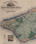
Currently, Viele map (1865) is shown as close-up of Water, Front and South streets (shown as A. below). I propose replacing it with a wider view below Houston (shown as B.). The close-up is contained in the wider view. The details are only visible when enlarged. Should both A. and B. be kept or just use B.? With only the wider view, it allows the curious reader to find the detail. I do like both of them. As a map person, I am too close to the subject to trust my judgement. Don't want to overwhelm the page with more than one view of the same map. - DutchTreat ( talk) 13:09, 27 January 2022 (UTC)
-
 A. Water, Front and South streets
(North is up) -
 B. below Houston Street
(North is on right) -
 C. below Fourteenth Street
(North is on right)
.png)
.png)
.png)
- B is much better to visually explain the wider geographical area and extent of reclamation.
- Thanks for your work. If we take the Wikipedia description of Lower Manhattan as being that :part of island being below 14th Street (arbitrary, I think) then a section of Viele map that :shows that would be ideal, especially since the article does, and I think should, address the :East River Park/"greater" Lower East Side. Djflem ( talk) 14:21, 27 January 2022 (UTC)
- Thanks, I prefer the wider view as well, as it makes the part of Manhattan under discussion much more recognizable.--
Pharos (
talk)
16:14, 27 January 2022 (UTC)
- @ Djflem and Pharos: I'll create a third version showing below 14th street. As the maps change scale, the finer details like the progression of the shoreline from Water -> Front -> South become more difficult to find. I'm willing to try alternatives to see which looks best. Thank you both for your input - DutchTreat ( talk) 00:49, 28 January 2022 (UTC)
- C. above shows below 14th Street. I added an inset map for details on shoreline differences between Water, Front and South Streets. This version I will place on the main article. For placement, I prefer this image on the top of the page above the shoreline in the {{
mapframe}}. Let me know if anyone has a concern with this approach. -
DutchTreat (
talk)
15:56, 28 January 2022 (UTC)
- Good choices qua map, inset and placement. Thanks.
Djflem (
talk)
17:55, 28 January 2022 (UTC)
- Map C. added to the article. Thanks again for the input. - DutchTreat ( talk) 10:32, 29 January 2022 (UTC)
- Good choices qua map, inset and placement. Thanks.
Djflem (
talk)
17:55, 28 January 2022 (UTC)
- Thanks, I prefer the wider view as well, as it makes the part of Manhattan under discussion much more recognizable.--
Pharos (
talk)
16:14, 27 January 2022 (UTC)
I think maybe we should expand #South Street-East River proposals to cover everything that's part of the "BIG U" and Lower Manhattan Coastal Resiliency proposals, and also probably spin out an independent Lower Manhattan Coastal Resiliency article when appropriate.-- Pharos ( talk) 03:01, 30 January 2022 (UTC)

|
| This article is rated Start-class on Wikipedia's
content assessment scale. It is of interest to the following WikiProjects: | ||||||||||
| |||||||||||
| Text and/or other creative content from Sixth borough was copied or moved into Lower Manhattan expansion with this edit on 18 January 2022. The former page's history now serves to provide attribution for that content in the latter page, and it must not be deleted as long as the latter page exists. |
1.2 cubic yards doesn't seem like a lot, and cursory examination of the next citation to appear doesn't reveal this figure. — Preceding unsigned comment added by 24.90.150.51 ( talk) 13:48, 19 January 2022 (UTC)
- Indeed you're right, it looks like the number for Battery Park City has been corrected now to 1.2 million cubic yards.-- Pharos ( talk) 19:37, 19 January 2022 (UTC)
If we could get something like the amount of acreage added in each century, that would make for a pretty interesting bar graph.-- Pharos ( talk) 14:42, 22 January 2022 (UTC)
Almost all of T. Kennard Thomson's designs should be in the public domain, except for the 1930 revisions, and including everything in the NYPL Digital Collections scrapbook. The challenge for some of them just might be to find more legible digital copies. Also, probably the best single multimedia for this article would be a navigable street map with an overlay of the original shoreline.-- Pharos ( talk) 19:59, 19 January 2022 (UTC)
- @ Pharos: Using the Viele (1865) map, created a shoreline circa 1600. Updated the article with a navigable street map using {{ mapframe}}. Please expand upon how you see using Thomas Kennard's designs used in a multimedia exhibit. - DutchTreat ( talk) 12:34, 26 January 2022 (UTC)
We've designated this article as the Wikipedia:WikiProject New York City/Monthly collaboration for January.-- Pharos ( talk) 18:20, 21 January 2022 (UTC)
At some point we may want to start Land reclamation in New York City, on the model of articles for other cities ( Hong Kong, Metro Manila, Monaco, Singapore), though I think for now Lower Manhattan is a distinct enough topic by itself.-- Pharos ( talk) 20:45, 21 January 2022 (UTC)
- Buttenwieser, Ann L. (1999), Manhattan Water-Bound: Manhattan’s Waterfront from the Seventeenth Century to the Present, Syracuse University Press, ISBN 9780815628019 Djflem ( talk) 20:11, 23 January 2022 (UTC)
Currently, Viele map (1865) is shown as close-up of Water, Front and South streets (shown as A. below). I propose replacing it with a wider view below Houston (shown as B.). The close-up is contained in the wider view. The details are only visible when enlarged. Should both A. and B. be kept or just use B.? With only the wider view, it allows the curious reader to find the detail. I do like both of them. As a map person, I am too close to the subject to trust my judgement. Don't want to overwhelm the page with more than one view of the same map. - DutchTreat ( talk) 13:09, 27 January 2022 (UTC)
-
A. Water, Front and South streets
(North is up) -
B. below Houston Street
(North is on right) -
C. below Fourteenth Street
(North is on right)
- B is much better to visually explain the wider geographical area and extent of reclamation.
- Thanks for your work. If we take the Wikipedia description of Lower Manhattan as being that :part of island being below 14th Street (arbitrary, I think) then a section of Viele map that :shows that would be ideal, especially since the article does, and I think should, address the :East River Park/"greater" Lower East Side. Djflem ( talk) 14:21, 27 January 2022 (UTC)
- Thanks, I prefer the wider view as well, as it makes the part of Manhattan under discussion much more recognizable.--
Pharos (
talk)
16:14, 27 January 2022 (UTC)
- @ Djflem and Pharos: I'll create a third version showing below 14th street. As the maps change scale, the finer details like the progression of the shoreline from Water -> Front -> South become more difficult to find. I'm willing to try alternatives to see which looks best. Thank you both for your input - DutchTreat ( talk) 00:49, 28 January 2022 (UTC)
- C. above shows below 14th Street. I added an inset map for details on shoreline differences between Water, Front and South Streets. This version I will place on the main article. For placement, I prefer this image on the top of the page above the shoreline in the {{
mapframe}}. Let me know if anyone has a concern with this approach. -
DutchTreat (
talk)
15:56, 28 January 2022 (UTC)
- Good choices qua map, inset and placement. Thanks.
Djflem (
talk)
17:55, 28 January 2022 (UTC)
- Map C. added to the article. Thanks again for the input. - DutchTreat ( talk) 10:32, 29 January 2022 (UTC)
- Good choices qua map, inset and placement. Thanks.
Djflem (
talk)
17:55, 28 January 2022 (UTC)
- Thanks, I prefer the wider view as well, as it makes the part of Manhattan under discussion much more recognizable.--
Pharos (
talk)
16:14, 27 January 2022 (UTC)
I think maybe we should expand #South Street-East River proposals to cover everything that's part of the "BIG U" and Lower Manhattan Coastal Resiliency proposals, and also probably spin out an independent Lower Manhattan Coastal Resiliency article when appropriate.-- Pharos ( talk) 03:01, 30 January 2022 (UTC)