|
| This article is rated C-class on Wikipedia's
content assessment scale. It is of interest to the following WikiProjects: | |||||||||||||||||||||||||||||||||||||||||||||||||||||||||||||||||||||||||||||||
| ||||||||||||||||||||||||||||||||||||||||||||||||||||||||||||||||||||||||||||||||


this article needs references. And it needs some things explained such as:
- how does this region relate to the North American Southwest? Is it a subregion of the Southwest?
- what is the origin of this term? who coined it?
- has the definition of Aridoamerica changed?
- what peoples are considered Aridoamericans?
- how popular is this term? (for example, the term is not prominent in the Handbook of North American Indians?)
- are peoples of this region who lived near good water sources excluded?
– ishwar (speak) 17:07, 12 June 2006 (UTC)
and such as:
How aridoamerica is limited by the US-Mexican border, established in 1849 ??? Nobody can have a look on spanish speaking web pages instead of propagating "racial based" informations ?
This a very poor article....
An european dude. —Preceding unsigned comment added by 201.143.49.27 ( talk) 00:25, 27 May 2009 (UTC)
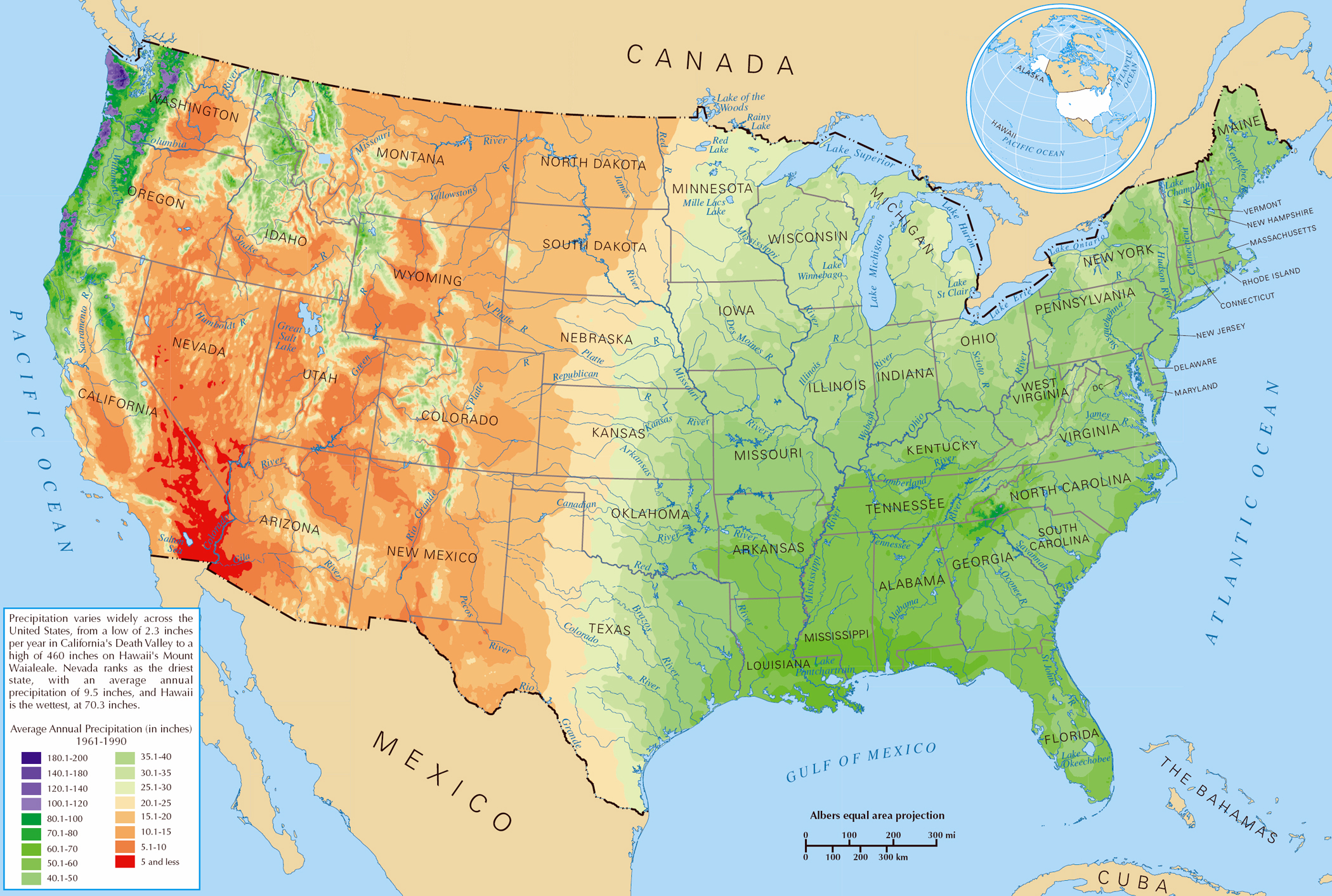
I'm afraid that I have to question the map. "Aridoamerica" is supposed to cover the desert or near-desert regions of Mexico and the Southwest U.S. that had significant pre-Columbian populations. The map shown encompasses large swaths of forested areas and even a great deal of swampland. The sources listed do not appear to explicitly define this region per se. You can look at the following for reference:
Precipitation Map
This shows that approximately 1/10 - 1/5 of the area shown on the map in the northeast cannot be classified in this way.
Is there any actual documentation that shows that anthropologists or geographers actually use the term in this way?
--MC — Preceding unsigned comment added by 192.88.168.1 ( talk) 14:53, 4 October 2013 (UTC)
The claim that the region receives 120 to 160 cm of precipitation annually is way off. In addition to the map referenced by MC above, I used a quick search to find the following: http://kids.britannica.com/comptons/art-166534/Average-annual-precipitation-for-North-America which shows that most of the region shown on the map of "Aridoamerica" receives 20 to 80 cm per year. LittlePortion ( talk) 18:05, 18 January 2016 (UTC)
Accepting the presumed convenience of representing what are actually transition zones by lines, the map labeled Aridoamerica needs a northern boundary to enclose the appropriate space, and U.S. states outlined as Mexican states are. Barefoot through the chollas ( talk) 20:08, 30 May 2024 (UTC)
- C-Class Indigenous peoples of North America articles
- Mid-importance Indigenous peoples of North America articles
- WikiProject Indigenous peoples of North America articles
- C-Class Indigenous peoples of the Americas articles
- Mid-importance Indigenous peoples of the Americas articles
- Indigenous peoples of the Americas articles
- C-Class North America articles
- Mid-importance North America articles
- WikiProject North America articles
- C-Class Mexico articles
- Mid-importance Mexico articles
- WikiProject Mexico articles
- C-Class United States articles
- Mid-importance United States articles
- C-Class United States articles of Mid-importance
- C-Class Arizona articles
- Low-importance Arizona articles
- WikiProject Arizona articles
- C-Class New Mexico articles
- Unknown-importance New Mexico articles
- WikiProject New Mexico articles
- C-Class Texas articles
- Mid-importance Texas articles
- WikiProject Texas articles
- WikiProject United States articles
- C-Class California articles
- Unknown-importance California articles
- WikiProject California articles
- C-Class Archaeology articles
- Unknown-importance Archaeology articles
|
| This article is rated C-class on Wikipedia's
content assessment scale. It is of interest to the following WikiProjects: | |||||||||||||||||||||||||||||||||||||||||||||||||||||||||||||||||||||||||||||||
| ||||||||||||||||||||||||||||||||||||||||||||||||||||||||||||||||||||||||||||||||
this article needs references. And it needs some things explained such as:
- how does this region relate to the North American Southwest? Is it a subregion of the Southwest?
- what is the origin of this term? who coined it?
- has the definition of Aridoamerica changed?
- what peoples are considered Aridoamericans?
- how popular is this term? (for example, the term is not prominent in the Handbook of North American Indians?)
- are peoples of this region who lived near good water sources excluded?
– ishwar (speak) 17:07, 12 June 2006 (UTC)
and such as:
How aridoamerica is limited by the US-Mexican border, established in 1849 ??? Nobody can have a look on spanish speaking web pages instead of propagating "racial based" informations ?
This a very poor article....
An european dude. —Preceding unsigned comment added by 201.143.49.27 ( talk) 00:25, 27 May 2009 (UTC)
I'm afraid that I have to question the map. "Aridoamerica" is supposed to cover the desert or near-desert regions of Mexico and the Southwest U.S. that had significant pre-Columbian populations. The map shown encompasses large swaths of forested areas and even a great deal of swampland. The sources listed do not appear to explicitly define this region per se. You can look at the following for reference:
Precipitation Map
This shows that approximately 1/10 - 1/5 of the area shown on the map in the northeast cannot be classified in this way.
Is there any actual documentation that shows that anthropologists or geographers actually use the term in this way?
--MC — Preceding unsigned comment added by 192.88.168.1 ( talk) 14:53, 4 October 2013 (UTC)
The claim that the region receives 120 to 160 cm of precipitation annually is way off. In addition to the map referenced by MC above, I used a quick search to find the following: http://kids.britannica.com/comptons/art-166534/Average-annual-precipitation-for-North-America which shows that most of the region shown on the map of "Aridoamerica" receives 20 to 80 cm per year. LittlePortion ( talk) 18:05, 18 January 2016 (UTC)
Accepting the presumed convenience of representing what are actually transition zones by lines, the map labeled Aridoamerica needs a northern boundary to enclose the appropriate space, and U.S. states outlined as Mexican states are. Barefoot through the chollas ( talk) 20:08, 30 May 2024 (UTC)
- C-Class Indigenous peoples of North America articles
- Mid-importance Indigenous peoples of North America articles
- WikiProject Indigenous peoples of North America articles
- C-Class Indigenous peoples of the Americas articles
- Mid-importance Indigenous peoples of the Americas articles
- Indigenous peoples of the Americas articles
- C-Class North America articles
- Mid-importance North America articles
- WikiProject North America articles
- C-Class Mexico articles
- Mid-importance Mexico articles
- WikiProject Mexico articles
- C-Class United States articles
- Mid-importance United States articles
- C-Class United States articles of Mid-importance
- C-Class Arizona articles
- Low-importance Arizona articles
- WikiProject Arizona articles
- C-Class New Mexico articles
- Unknown-importance New Mexico articles
- WikiProject New Mexico articles
- C-Class Texas articles
- Mid-importance Texas articles
- WikiProject Texas articles
- WikiProject United States articles
- C-Class California articles
- Unknown-importance California articles
- WikiProject California articles
- C-Class Archaeology articles
- Unknown-importance Archaeology articles