Stoutenburg | |
|---|---|
Village and neighbourhood | |
 Street view | |
 Stoutenburg Location in the Netherlands  Stoutenburg Stoutenburg (Netherlands) | |
| Coordinates: 52°9′14″N 5°25′57″E / 52.15389°N 5.43250°E | |
| Country | Netherlands |
| Province | Utrecht |
| Municipality |
Leusden Amersfoort |
| Area | |
| • Total | 6.89 km2 (2.66 sq mi) |
| Elevation | 4 m (13 ft) |
| Population (2021)
[1] | |
| • Total | 485 |
| • Density | 70/km2 (180/sq mi) |
| Time zone | UTC+1 ( CET) |
| • Summer ( DST) | UTC+2 ( CEST) |
| Postal code | 3835 & 3836
[1] |
| Dialing code | 033 |
Stoutenburg is a village in the Dutch province of Utrecht. It is a part of the municipality of Leusden, and lies about 4 km (2 mi) east of Amersfoort. Since 1998, a part of the village is a neighbourhood in Amersfoort.
History
The village was first mentioned in 1262 as Walter van Stoltenberch, and means "strong hill" which is a reference to castle Stoutenburg. [3]
In 1252, the castle Stoutenburg near the village was founded by the lord of Amersfoort. From 1615, the castle was owned by Johan van Oldenbarnevelt. The castle was replaced by a manor, built in 1888. In 1948, the estate which was heavily damaged by war was bought by the Franciscans, and in 1952, a monastery opened. In 2019, the manor house was turned in an apartment building for people with Alzheimer. [4] [5] [6]
In 1840, Stoutenburg was home to 584 people. [6] Until 1 June 1969, Stoutenburg was a separate municipality, covering the villages of Stoutenburg and Achterveld. Most of the territory of the former municipality is now part of Leusden; the northern part was annexed by the municipality of Amersfoort in 1998. [6]
Gallery
-
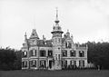 Castle Stoutenburg (1891)
 -
 Farm in Stoutenburg
 -
 Nature area De Schammer
 -
 Former toll house


.jpg)

References
- ^
a
b
c
"Kerncijfers wijken en buurten 2021". Central Bureau of Statistics. Retrieved 28 March 2022.
two entries / 130 in Amersfoort postcode 3836
- ^ "Postcodetool for 3835PB". Actueel Hoogtebestand Nederland (in Dutch). Het Waterschapshuis. Retrieved 28 March 2022.
- ^ "Stoutenburg - (geografische naam)". Etymologiebank (in Dutch). Retrieved 28 March 2022.
- ^ "Stoutenberg". Utrechtse buitenplaatsen (in Dutch). Retrieved 28 March 2022.
- ^ "Kasteel Stoutenberg". Legemaat van Elst (in Dutch). Retrieved 28 March 2022.
- ^ a b c "Stoutenburg". Plaatsengids (in Dutch). Retrieved 28 March 2022.
Stoutenburg | |
|---|---|
Village and neighbourhood | |
|
Street view | |
Stoutenburg Location in the Netherlands Stoutenburg Stoutenburg (Netherlands) | |
| Coordinates: 52°9′14″N 5°25′57″E / 52.15389°N 5.43250°E | |
| Country | Netherlands |
| Province | Utrecht |
| Municipality |
Leusden Amersfoort |
| Area | |
| • Total | 6.89 km2 (2.66 sq mi) |
| Elevation | 4 m (13 ft) |
| Population (2021)
[1] | |
| • Total | 485 |
| • Density | 70/km2 (180/sq mi) |
| Time zone | UTC+1 ( CET) |
| • Summer ( DST) | UTC+2 ( CEST) |
| Postal code | 3835 & 3836
[1] |
| Dialing code | 033 |
Stoutenburg is a village in the Dutch province of Utrecht. It is a part of the municipality of Leusden, and lies about 4 km (2 mi) east of Amersfoort. Since 1998, a part of the village is a neighbourhood in Amersfoort.
History
The village was first mentioned in 1262 as Walter van Stoltenberch, and means "strong hill" which is a reference to castle Stoutenburg. [3]
In 1252, the castle Stoutenburg near the village was founded by the lord of Amersfoort. From 1615, the castle was owned by Johan van Oldenbarnevelt. The castle was replaced by a manor, built in 1888. In 1948, the estate which was heavily damaged by war was bought by the Franciscans, and in 1952, a monastery opened. In 2019, the manor house was turned in an apartment building for people with Alzheimer. [4] [5] [6]
In 1840, Stoutenburg was home to 584 people. [6] Until 1 June 1969, Stoutenburg was a separate municipality, covering the villages of Stoutenburg and Achterveld. Most of the territory of the former municipality is now part of Leusden; the northern part was annexed by the municipality of Amersfoort in 1998. [6]
Gallery
-
Castle Stoutenburg (1891)
-
Farm in Stoutenburg
-
Nature area De Schammer
-
Former toll house
References
- ^
a
b
c
"Kerncijfers wijken en buurten 2021". Central Bureau of Statistics. Retrieved 28 March 2022.
two entries / 130 in Amersfoort postcode 3836
- ^ "Postcodetool for 3835PB". Actueel Hoogtebestand Nederland (in Dutch). Het Waterschapshuis. Retrieved 28 March 2022.
- ^ "Stoutenburg - (geografische naam)". Etymologiebank (in Dutch). Retrieved 28 March 2022.
- ^ "Stoutenberg". Utrechtse buitenplaatsen (in Dutch). Retrieved 28 March 2022.
- ^ "Kasteel Stoutenberg". Legemaat van Elst (in Dutch). Retrieved 28 March 2022.
- ^ a b c "Stoutenburg". Plaatsengids (in Dutch). Retrieved 28 March 2022.