Asschat | |
|---|---|
 Farm in Asschat | |
 Asschat Location in the Netherlands  Asschat Asschat (Netherlands) | |
| Coordinates: 52°7′54″N 5°27′1″E / 52.13167°N 5.45028°E | |
| Country | Netherlands |
| Province | Utrecht |
| Municipality | Leusden |
| Time zone | UTC+1 ( CET) |
| • Summer ( DST) | UTC+2 ( CEST) |
| Postal code | 3431
[1] |
| Dialing code | 033 [1] |
Asschat is a hamlet in the municipality Leusden, in the Dutch province of Utrecht.
The hamlet is separated from the village of Leusden in the west by the Valleikanaal canal, and it borders the hamlet Snorrenhoef in the east. The name Asschat (1696) derives from af-schede, afscheiding: partition, indicating an old border. [2]
Asschat is not a statistical entity, [3] and the postal authorities have placed it under Leusden. [1] It used to have place name signs, however they have been removed. In 1840, Asschat was home to 172 people. At the outbreak of World War II, it was the scene of heavy fighting. All the farms were set on fire to slow the German advance. The animals were set free, but some returned to their farm. Nowadays, it consists of about 20 houses. [4]
The family Scholten van Aschat is named after the hamlet.
Gallery
-
 World War II bunker in Asschat
 -
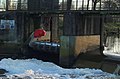 Weir and mini hydroelectric plant in Asschat


References
- ^ a b c "Postcode 3831 in Leusden". Postcode bij adres (in Dutch). Retrieved 28 March 2022.
- ^ Berkel en Samplonius: Het Plaatsnamenboek, Unieboek Houten, 1989, ISBN 90-269-4321-0 (in Dutch)
-
^
"Kerncijfers wijken en buurten 2021". Central Bureau of Statistics. Retrieved 28 March 2022.
not found
- ^ "Asschat". Plaatsengids (in Dutch). Retrieved 28 March 2022.
52°7′54″N 5°27′20″E / 52.13167°N 5.45556°E
|
| This Utrecht location article is a stub. You can help Wikipedia by expanding it. |
Asschat | |
|---|---|
|
Farm in Asschat | |
Asschat Location in the Netherlands Asschat Asschat (Netherlands) | |
| Coordinates: 52°7′54″N 5°27′1″E / 52.13167°N 5.45028°E | |
| Country | Netherlands |
| Province | Utrecht |
| Municipality | Leusden |
| Time zone | UTC+1 ( CET) |
| • Summer ( DST) | UTC+2 ( CEST) |
| Postal code | 3431
[1] |
| Dialing code | 033 [1] |
Asschat is a hamlet in the municipality Leusden, in the Dutch province of Utrecht.
The hamlet is separated from the village of Leusden in the west by the Valleikanaal canal, and it borders the hamlet Snorrenhoef in the east. The name Asschat (1696) derives from af-schede, afscheiding: partition, indicating an old border. [2]
Asschat is not a statistical entity, [3] and the postal authorities have placed it under Leusden. [1] It used to have place name signs, however they have been removed. In 1840, Asschat was home to 172 people. At the outbreak of World War II, it was the scene of heavy fighting. All the farms were set on fire to slow the German advance. The animals were set free, but some returned to their farm. Nowadays, it consists of about 20 houses. [4]
The family Scholten van Aschat is named after the hamlet.
Gallery
-
World War II bunker in Asschat
-
Weir and mini hydroelectric plant in Asschat
References
- ^ a b c "Postcode 3831 in Leusden". Postcode bij adres (in Dutch). Retrieved 28 March 2022.
- ^ Berkel en Samplonius: Het Plaatsnamenboek, Unieboek Houten, 1989, ISBN 90-269-4321-0 (in Dutch)
-
^
"Kerncijfers wijken en buurten 2021". Central Bureau of Statistics. Retrieved 28 March 2022.
not found
- ^ "Asschat". Plaatsengids (in Dutch). Retrieved 28 March 2022.
52°7′54″N 5°27′20″E / 52.13167°N 5.45556°E
|
| This Utrecht location article is a stub. You can help Wikipedia by expanding it. |