Shrirampur | |
|---|---|
Village | |
 Shrirampur Location in West Bengal, India  Shrirampur Shrirampur (India) | |
| Coordinates: 22°13′17″N 87°35′02″E / 22.2215°N 87.5840°E | |
| Country | |
| State | West Bengal |
| District | Paschim Medinipur |
| Population (2011) | |
| • Total | 933 |
| Languages* | |
| • Official | Bengali, Santali, English |
| Time zone | UTC+5:30 ( IST) |
| PIN | 721144 (Sabang) |
| Telephone/ STD code | 03228 |
| Lok Sabha constituency | Ghatal |
| Vidhan Sabha constituency | Sabang |
| Website |
paschimmedinipur |
Shrirampur is a village in the Sabang CD block in the Kharagpur subdivision of the Paschim Medinipur district in the state of West Bengal, India.
Geography
5miles
CT: census town, R: rural/ urban centre, H: historical/ religious centre
Owing to space constraints in the small map, the actual locations in a larger map may vary slightly
Location
Shrirampur is located at 22°13′17″N 87°35′02″E / 22.2215°N 87.5840°E.
Area overview
Kharagpur subdivision, shown partly in the map alongside, mostly has alluvial soils, except in two CD blocks in the west – Kharagpur I and Keshiary, which mostly have lateritic soils. Around 74% of the total cultivated area is cropped more than once. [1] With a density of population of 787 per km2nearly half of the district's population resides in this subdivision. 14.33% of the population lives in urban areas and 86.67% lives in the rural areas. [2]
Note: The map alongside presents some of the notable locations in the subdivision. All places marked in the map are linked in the larger full screen map.
Demographics
According to the 2011 Census of India, Shrirampur had a total population of 933, of which 489 (52%) were males and 444 (48%) were females. There were 100 persons in the age range of 0–6 years. The total number of literate persons in Shrirampur was 778 (93.40% of the population over 6 years). [3]
.*For language details see Sabang (community development block)#Language and religion
Culture
David J. McCutchion mentions the Lakshmi Janardana temple of the Jana family as a richly terracotta decorated pancharatna with smooth rekha turrets measuring 17’ 8" square, built in 1870. [4]
Shrirampur picture gallery
-
 Lakshmi Janardana temple
 -
 Terracotta decoration
 -
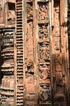 Terracotta decoration
 -
 Terracotta decoration


References
- ^ "District Human Development Report Paschim Medinipur, 2011". page 27-28. Department of Planning and Statistics, Government of West Bengal. Retrieved 10 September 2020.
- ^ "District Statistical Handbook Paschim Medinipur, 2013". Table 2.2, 2.4 (a). Department of Planning and Statistics. Retrieved 10 September 2020.
- ^ "CD block Wise Primary Census Abstract Data(PCA)". West Bengal – District-wise CD blocks. Registrar General and Census, India. Retrieved 19 August 2020.
- ^ McCutchion, David J., Late Mediaeval Temples of Bengal, first published 1972, reprinted 2017, page 49. The Asiatic Society, Kolkata, ISBN 978-93-81574-65-2
External links
Shrirampur | |
|---|---|
Village | |
Shrirampur Location in West Bengal, India Shrirampur Shrirampur (India) | |
| Coordinates: 22°13′17″N 87°35′02″E / 22.2215°N 87.5840°E | |
| Country | |
| State | West Bengal |
| District | Paschim Medinipur |
| Population (2011) | |
| • Total | 933 |
| Languages* | |
| • Official | Bengali, Santali, English |
| Time zone | UTC+5:30 ( IST) |
| PIN | 721144 (Sabang) |
| Telephone/ STD code | 03228 |
| Lok Sabha constituency | Ghatal |
| Vidhan Sabha constituency | Sabang |
| Website |
paschimmedinipur |
Shrirampur is a village in the Sabang CD block in the Kharagpur subdivision of the Paschim Medinipur district in the state of West Bengal, India.
Geography
5miles
CT: census town, R: rural/ urban centre, H: historical/ religious centre
Owing to space constraints in the small map, the actual locations in a larger map may vary slightly
Location
Shrirampur is located at 22°13′17″N 87°35′02″E / 22.2215°N 87.5840°E.
Area overview
Kharagpur subdivision, shown partly in the map alongside, mostly has alluvial soils, except in two CD blocks in the west – Kharagpur I and Keshiary, which mostly have lateritic soils. Around 74% of the total cultivated area is cropped more than once. [1] With a density of population of 787 per km2nearly half of the district's population resides in this subdivision. 14.33% of the population lives in urban areas and 86.67% lives in the rural areas. [2]
Note: The map alongside presents some of the notable locations in the subdivision. All places marked in the map are linked in the larger full screen map.
Demographics
According to the 2011 Census of India, Shrirampur had a total population of 933, of which 489 (52%) were males and 444 (48%) were females. There were 100 persons in the age range of 0–6 years. The total number of literate persons in Shrirampur was 778 (93.40% of the population over 6 years). [3]
.*For language details see Sabang (community development block)#Language and religion
Culture
David J. McCutchion mentions the Lakshmi Janardana temple of the Jana family as a richly terracotta decorated pancharatna with smooth rekha turrets measuring 17’ 8" square, built in 1870. [4]
Shrirampur picture gallery
-
Lakshmi Janardana temple
-
Terracotta decoration
-
Terracotta decoration
-
Terracotta decoration
References
- ^ "District Human Development Report Paschim Medinipur, 2011". page 27-28. Department of Planning and Statistics, Government of West Bengal. Retrieved 10 September 2020.
- ^ "District Statistical Handbook Paschim Medinipur, 2013". Table 2.2, 2.4 (a). Department of Planning and Statistics. Retrieved 10 September 2020.
- ^ "CD block Wise Primary Census Abstract Data(PCA)". West Bengal – District-wise CD blocks. Registrar General and Census, India. Retrieved 19 August 2020.
- ^ McCutchion, David J., Late Mediaeval Temples of Bengal, first published 1972, reprinted 2017, page 49. The Asiatic Society, Kolkata, ISBN 978-93-81574-65-2
External links
Cities, towns and locations in
Paschim Medinipur District,
Medinipur division | ||||||||
|---|---|---|---|---|---|---|---|---|
|
Cities,
municipal and census towns |
|  | ||||||
| Locations other than cities and towns |
| |||||||
| Related topics | ||||||||