Chak Bajit | |
|---|---|
Village | |
 Chak Bajit Location in West Bengal, India  Chak Bajit Chak Bajit (India) | |
| Coordinates: 22°25′14″N 87°36′17″E / 22.420611°N 87.604606°E | |
| Country | |
| State | West Bengal |
| District | Paschim Medinipur |
| Population (2011) | |
| • Total | 560 |
| Languages* | |
| • Official | Bengali, Santali, English |
| Time zone | UTC+5:30 ( IST) |
| PIN | 721136 |
| Telephone/ STD code | 03222 |
| Lok Sabha constituency | Ghatal |
| Vidhan Sabha constituency | Debra |
| Website |
paschimmedinipur |
Chak Bajit is a village in the Debra CD block in the Kharagpur subdivision of the Paschim Medinipur district in the state of West Bengal, India.
Geography
5miles
Madhyabar
Railway Settlement
M: municipal city/ town, CT: census town, R: rural/ urban centre, H: historical/ religious centre, F: facilities
Owing to space constraints in the small map, the actual locations in a larger map may vary slightly
Location
Chak Bajit is located at 22°25′14″N 87°36′17″E / 22.420611°N 87.604606°E.
Area overview
Kharagpur subdivision, shown partly in the map alongside, mostly has alluvial soils, except in two CD blocks in the west – Kharagpur I and Keshiary, which mostly have lateritic soils. Around 74% of the total cultivated area is cropped more than once. [1] With a density of population of 787 per km2nearly half of the district's population resides in this subdivision. 14.33% of the population lives in urban areas and 86.67% lives in the rural areas. [2]
Note: The map alongside presents some of the notable locations in the subdivision. All places marked in the map are linked in the larger full screen map.
Demographics
According to the 2011 Census of India, Chak Bajit had a total population of 560, of which 283 (51%) were males and 277 (49%) were females. There were 62 persons in the age range of 0–6 years. The total number of literate persons in Chak Bajit was 396 (79.52% of the population over 6 years). [3]
.*For language details see Debra (community development block)#Language and religion
Chak Bajit picture gallery
-
 Sapta ratha deul of Sridharjiu and Gour Nitai
 -
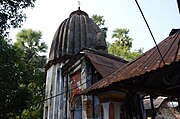
 Rameswar Shiva deul
 -
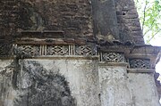 Decorations in Rameswar Shiva deul


References
- ^ "District Human Development Report Paschim Medinipur, 2011". page 27-28. Department of Planning and Statistics, Government of West Bengal. Retrieved 10 September 2020.
- ^ "District Statistical Handbook Paschim Medinipur, 2013". Table 2.2, 2.4 (a). Department of Planning and Statistics. Retrieved 10 September 2020.
- ^ "CD block Wise Primary Census Abstract Data(PCA)". West Bengal – District-wise CD blocks. Registrar General and Census, India. Retrieved 3 September 2020.
External links
Chak Bajit | |
|---|---|
Village | |
Chak Bajit Location in West Bengal, India Chak Bajit Chak Bajit (India) | |
| Coordinates: 22°25′14″N 87°36′17″E / 22.420611°N 87.604606°E | |
| Country | |
| State | West Bengal |
| District | Paschim Medinipur |
| Population (2011) | |
| • Total | 560 |
| Languages* | |
| • Official | Bengali, Santali, English |
| Time zone | UTC+5:30 ( IST) |
| PIN | 721136 |
| Telephone/ STD code | 03222 |
| Lok Sabha constituency | Ghatal |
| Vidhan Sabha constituency | Debra |
| Website |
paschimmedinipur |
Chak Bajit is a village in the Debra CD block in the Kharagpur subdivision of the Paschim Medinipur district in the state of West Bengal, India.
Geography
5miles
Madhyabar
Railway Settlement
M: municipal city/ town, CT: census town, R: rural/ urban centre, H: historical/ religious centre, F: facilities
Owing to space constraints in the small map, the actual locations in a larger map may vary slightly
Location
Chak Bajit is located at 22°25′14″N 87°36′17″E / 22.420611°N 87.604606°E.
Area overview
Kharagpur subdivision, shown partly in the map alongside, mostly has alluvial soils, except in two CD blocks in the west – Kharagpur I and Keshiary, which mostly have lateritic soils. Around 74% of the total cultivated area is cropped more than once. [1] With a density of population of 787 per km2nearly half of the district's population resides in this subdivision. 14.33% of the population lives in urban areas and 86.67% lives in the rural areas. [2]
Note: The map alongside presents some of the notable locations in the subdivision. All places marked in the map are linked in the larger full screen map.
Demographics
According to the 2011 Census of India, Chak Bajit had a total population of 560, of which 283 (51%) were males and 277 (49%) were females. There were 62 persons in the age range of 0–6 years. The total number of literate persons in Chak Bajit was 396 (79.52% of the population over 6 years). [3]
.*For language details see Debra (community development block)#Language and religion
Chak Bajit picture gallery
-
Sapta ratha deul of Sridharjiu and Gour Nitai
-
Rameswar Shiva deul
-
Decorations in Rameswar Shiva deul
References
- ^ "District Human Development Report Paschim Medinipur, 2011". page 27-28. Department of Planning and Statistics, Government of West Bengal. Retrieved 10 September 2020.
- ^ "District Statistical Handbook Paschim Medinipur, 2013". Table 2.2, 2.4 (a). Department of Planning and Statistics. Retrieved 10 September 2020.
- ^ "CD block Wise Primary Census Abstract Data(PCA)". West Bengal – District-wise CD blocks. Registrar General and Census, India. Retrieved 3 September 2020.
External links
Cities, towns and locations in
Paschim Medinipur District,
Medinipur division | ||||||||
|---|---|---|---|---|---|---|---|---|
|
Cities,
municipal and census towns |
|  | ||||||
| Locations other than cities and towns |
| |||||||
| Related topics | ||||||||