San Agustín, Huila | |
|---|---|
Municipality and town | |
_Village.JPG) | |
.svg) Flag | |
 Location of the municipality and town of San Agustín, Córdoba in the Huila Department of Colombia. | |
| Country | |
| Department | Huila Department |
| Population (2020 est.
[1]) | |
| • Total | 34,420 |
| Time zone | UTC-5 (Colombia Standard Time) |
San Agustín (Spanish pronunciation: [san aɣusˈtin]) is a town and municipality in the southern Colombian Department of Huila. The town is located 227 km away from the capital of the Department, Neiva. Population is around 34,000. [1] The village was founded in 1752 by Alejo Astudillo but attacks by indigenous people destroyed it. The present village was founded in 1790 by Lucas de Herazo y Mendigaña.
The mean temperature year round is 18 °C.
San Agustín has a subtropical highland climate ( Köppen: Cfb) [2] with warm temperatures and frequent rainfall.
| Climate data for San Agustín (Parque Arqueologic), elevation 1,800 m (5,900 ft), (1981–2010) | |||||||||||||
|---|---|---|---|---|---|---|---|---|---|---|---|---|---|
| Month | Jan | Feb | Mar | Apr | May | Jun | Jul | Aug | Sep | Oct | Nov | Dec | Year |
| Mean daily maximum °C (°F) | 23.9 (75.0) |
24.0 (75.2) |
23.5 (74.3) |
23.3 (73.9) |
22.8 (73.0) |
21.8 (71.2) |
21.0 (69.8) |
21.6 (70.9) |
22.8 (73.0) |
23.5 (74.3) |
23.5 (74.3) |
23.6 (74.5) |
22.9 (73.2) |
| Daily mean °C (°F) | 18.7 (65.7) |
18.8 (65.8) |
18.7 (65.7) |
18.6 (65.5) |
18.3 (64.9) |
17.6 (63.7) |
17.0 (62.6) |
17.2 (63.0) |
17.9 (64.2) |
18.4 (65.1) |
18.5 (65.3) |
18.5 (65.3) |
18.2 (64.8) |
| Mean daily minimum °C (°F) | 13.9 (57.0) |
14.1 (57.4) |
14.3 (57.7) |
14.4 (57.9) |
14.3 (57.7) |
13.8 (56.8) |
13.2 (55.8) |
13.0 (55.4) |
13.2 (55.8) |
13.8 (56.8) |
14.1 (57.4) |
14.0 (57.2) |
13.8 (56.8) |
| Average precipitation mm (inches) | 88.0 (3.46) |
101.6 (4.00) |
127.9 (5.04) |
157.0 (6.18) |
147.7 (5.81) |
154.6 (6.09) |
137.9 (5.43) |
103.8 (4.09) |
92.7 (3.65) |
119.3 (4.70) |
141.0 (5.55) |
117.2 (4.61) |
1,488.8 (58.61) |
| Average precipitation days | 16 | 17 | 20 | 23 | 24 | 24 | 24 | 23 | 21 | 21 | 21 | 19 | 250 |
| Average relative humidity (%) | 78 | 78 | 79 | 81 | 82 | 83 | 83 | 81 | 79 | 79 | 81 | 80 | 80 |
| Mean monthly sunshine hours | 158.1 | 127.0 | 111.6 | 111.0 | 124.0 | 108.0 | 108.5 | 117.8 | 129.0 | 139.5 | 141.0 | 158.1 | 1,533.6 |
| Mean daily sunshine hours | 5.1 | 4.5 | 3.6 | 3.7 | 4.0 | 3.6 | 3.5 | 3.8 | 4.3 | 4.5 | 4.7 | 5.1 | 4.2 |
| Source: Instituto de Hidrologia Meteorologia y Estudios Ambientales [3] | |||||||||||||
The area is very well known for its pre-Columbian archaeological sites belonging to the ancient San Agustin culture. These sites comprise the San Agustín Archaeological Park, which generates significant revenue to the economy due to the high volume of tourists, both Colombian and foreigners. This site was declared a UNESCO World Heritage Site in 1995.
-
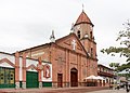 Church of San Agustín
 -
 Stone carving
 -
 Market
 -


- Video and downloadable GPS Track of a loop hike in San Agustin to the ruins of El Tablon, La Chaquira, El Purutal, and La Pelota.
-
 Media related to
San Agustín, Huila at Wikimedia Commons
Media related to
San Agustín, Huila at Wikimedia Commons -
 San Agustin travel guide from Wikivoyage
 - Unesco's website on San Agustin
- ^ a b "Resultados y proyecciones (2005-2020) del censo 2005". Retrieved 17 April 2020.
- ^ "Table 1 Overview of the Köppen-Geiger climate classes including the defining criteria". Nature: Scientific Data. 23 October 2023.
- ^ "Promedios Climatológicos 1981–2010" (in Spanish). Instituto de Hidrologia Meteorologia y Estudios Ambientales. Archived from the original on 15 August 2016. Retrieved 17 June 2024.
| ||
| Prehistoric- preceramic |  | |
|---|---|---|
| Preceramic-ceramic | ||
| International | |
|---|---|
| National | |
| Other | |
1°54′N 76°17′W / 1.900°N 76.283°W
|
| This Huila Department location article is a stub. You can help Wikipedia by expanding it. |
- Municipalities of Huila Department
- Archaeological parks
- Archaeological sites in Colombia
- Populated places established in 1752
- 1750s establishments in the Viceroyalty of New Granada
- 1752 establishments in South America
- Populated places established in 1790
- 1790s establishments in the Viceroyalty of New Granada
- 1790 establishments in South America
- Tourist attractions in Huila Department
- World Heritage Sites in Colombia
- Andean Region (Colombia) geography stubs
San Agustín, Huila | |
|---|---|
Municipality and town | |
|
| |
|
Flag | |
|
Location of the municipality and town of San Agustín, Córdoba in the Huila Department of Colombia. | |
| Country | |
| Department | Huila Department |
| Population (2020 est.
[1]) | |
| • Total | 34,420 |
| Time zone | UTC-5 (Colombia Standard Time) |
San Agustín (Spanish pronunciation: [san aɣusˈtin]) is a town and municipality in the southern Colombian Department of Huila. The town is located 227 km away from the capital of the Department, Neiva. Population is around 34,000. [1] The village was founded in 1752 by Alejo Astudillo but attacks by indigenous people destroyed it. The present village was founded in 1790 by Lucas de Herazo y Mendigaña.
The mean temperature year round is 18 °C.
San Agustín has a subtropical highland climate ( Köppen: Cfb) [2] with warm temperatures and frequent rainfall.
| Climate data for San Agustín (Parque Arqueologic), elevation 1,800 m (5,900 ft), (1981–2010) | |||||||||||||
|---|---|---|---|---|---|---|---|---|---|---|---|---|---|
| Month | Jan | Feb | Mar | Apr | May | Jun | Jul | Aug | Sep | Oct | Nov | Dec | Year |
| Mean daily maximum °C (°F) | 23.9 (75.0) |
24.0 (75.2) |
23.5 (74.3) |
23.3 (73.9) |
22.8 (73.0) |
21.8 (71.2) |
21.0 (69.8) |
21.6 (70.9) |
22.8 (73.0) |
23.5 (74.3) |
23.5 (74.3) |
23.6 (74.5) |
22.9 (73.2) |
| Daily mean °C (°F) | 18.7 (65.7) |
18.8 (65.8) |
18.7 (65.7) |
18.6 (65.5) |
18.3 (64.9) |
17.6 (63.7) |
17.0 (62.6) |
17.2 (63.0) |
17.9 (64.2) |
18.4 (65.1) |
18.5 (65.3) |
18.5 (65.3) |
18.2 (64.8) |
| Mean daily minimum °C (°F) | 13.9 (57.0) |
14.1 (57.4) |
14.3 (57.7) |
14.4 (57.9) |
14.3 (57.7) |
13.8 (56.8) |
13.2 (55.8) |
13.0 (55.4) |
13.2 (55.8) |
13.8 (56.8) |
14.1 (57.4) |
14.0 (57.2) |
13.8 (56.8) |
| Average precipitation mm (inches) | 88.0 (3.46) |
101.6 (4.00) |
127.9 (5.04) |
157.0 (6.18) |
147.7 (5.81) |
154.6 (6.09) |
137.9 (5.43) |
103.8 (4.09) |
92.7 (3.65) |
119.3 (4.70) |
141.0 (5.55) |
117.2 (4.61) |
1,488.8 (58.61) |
| Average precipitation days | 16 | 17 | 20 | 23 | 24 | 24 | 24 | 23 | 21 | 21 | 21 | 19 | 250 |
| Average relative humidity (%) | 78 | 78 | 79 | 81 | 82 | 83 | 83 | 81 | 79 | 79 | 81 | 80 | 80 |
| Mean monthly sunshine hours | 158.1 | 127.0 | 111.6 | 111.0 | 124.0 | 108.0 | 108.5 | 117.8 | 129.0 | 139.5 | 141.0 | 158.1 | 1,533.6 |
| Mean daily sunshine hours | 5.1 | 4.5 | 3.6 | 3.7 | 4.0 | 3.6 | 3.5 | 3.8 | 4.3 | 4.5 | 4.7 | 5.1 | 4.2 |
| Source: Instituto de Hidrologia Meteorologia y Estudios Ambientales [3] | |||||||||||||
The area is very well known for its pre-Columbian archaeological sites belonging to the ancient San Agustin culture. These sites comprise the San Agustín Archaeological Park, which generates significant revenue to the economy due to the high volume of tourists, both Colombian and foreigners. This site was declared a UNESCO World Heritage Site in 1995.
-
Church of San Agustín
-
Stone carving
-
Market
-
- Video and downloadable GPS Track of a loop hike in San Agustin to the ruins of El Tablon, La Chaquira, El Purutal, and La Pelota.
-
Media related to
San Agustín, Huila at Wikimedia Commons
-
San Agustin travel guide from Wikivoyage
- Unesco's website on San Agustin
- ^ a b "Resultados y proyecciones (2005-2020) del censo 2005". Retrieved 17 April 2020.
- ^ "Table 1 Overview of the Köppen-Geiger climate classes including the defining criteria". Nature: Scientific Data. 23 October 2023.
- ^ "Promedios Climatológicos 1981–2010" (in Spanish). Instituto de Hidrologia Meteorologia y Estudios Ambientales. Archived from the original on 15 August 2016. Retrieved 17 June 2024.
| ||
| Americas | ||||||||||||||||||||||||||||||||||||||||||||||||||||||||||||||||||||||||||||||||||||||||||||||||||||||
|---|---|---|---|---|---|---|---|---|---|---|---|---|---|---|---|---|---|---|---|---|---|---|---|---|---|---|---|---|---|---|---|---|---|---|---|---|---|---|---|---|---|---|---|---|---|---|---|---|---|---|---|---|---|---|---|---|---|---|---|---|---|---|---|---|---|---|---|---|---|---|---|---|---|---|---|---|---|---|---|---|---|---|---|---|---|---|---|---|---|---|---|---|---|---|---|---|---|---|---|---|---|---|
| North America | ||||||||||||||||||||||||||||||||||||||||||||||||||||||||||||||||||||||||||||||||||||||||||||||||||||||
| Mesoamerica |
| |||||||||||||||||||||||||||||||||||||||||||||||||||||||||||||||||||||||||||||||||||||||||||||||||||||
| South America |
| |||||||||||||||||||||||||||||||||||||||||||||||||||||||||||||||||||||||||||||||||||||||||||||||||||||
| ||||||||||||||||||||||||||||||||||||||||||||||||||||||||||||||||||||||||||||||||||||||||||||||||||||||
| Prehistoric- preceramic | | |
|---|---|---|
| Preceramic-ceramic | ||
| International | |
|---|---|
| National | |
| Other | |
1°54′N 76°17′W / 1.900°N 76.283°W
|
| This Huila Department location article is a stub. You can help Wikipedia by expanding it. |
- Municipalities of Huila Department
- Archaeological parks
- Archaeological sites in Colombia
- Populated places established in 1752
- 1750s establishments in the Viceroyalty of New Granada
- 1752 establishments in South America
- Populated places established in 1790
- 1790s establishments in the Viceroyalty of New Granada
- 1790 establishments in South America
- Tourist attractions in Huila Department
- World Heritage Sites in Colombia
- Andean Region (Colombia) geography stubs