Saint-Jean-des-Échelles | |
|---|---|
 Saint-Jean-des-Échelles  Saint-Jean-des-Échelles | |
| Coordinates: 48°07′47″N 0°42′47″E / 48.1297°N 0.7131°E | |
| Country | France |
| Region | Pays de la Loire |
| Department | Sarthe |
| Arrondissement | Mamers |
| Canton | Saint-Calais |
| Intercommunality | Pays de l'Huisne Sarthoise |
| Government | |
| • Mayor (2020–2026) | Yves Goullier [1] |
| Area 1 | 10.64 km2 (4.11 sq mi) |
| Population (2021)
[2] | 227 |
| • Density | 21/km2 (55/sq mi) |
| Time zone | UTC+01:00 ( CET) |
| • Summer ( DST) | UTC+02:00 ( CEST) |
| INSEE/Postal code |
72292 /72320 |
| Elevation | 104–200 m (341–656 ft) |
| 1 French Land Register data, which excludes lakes, ponds, glaciers > 1 km2 (0.386 sq mi or 247 acres) and river estuaries. | |
Saint-Jean-des-Échelles (French pronunciation: [sɛ̃ ʒɑ̃ de.z‿eʃɛl]) is a commune in the Sarthe department in the region of Pays de la Loire in north-western France.
There are two notable buildings in Saint-Jean-des-Échelles. The parish church of Saint-Jean-Baptiste dates from the 12ht century. It contains ten bas-reliefs from the 16th century,and three altars and altarpieces from the 18th century. The whole is listed as a historical monument. Secondly, Courtangis Castle forms part of the locality.
Gallery
-
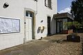 The townhall.
 -
 Unusual communal Lavoir or clothes washing place.
 -
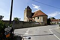 Parish church with rounded body and square tower
 -
 Interior of parish church


See also
References
- ^ "Répertoire national des élus: les maires". data.gouv.fr, Plateforme ouverte des données publiques françaises (in French). 2 December 2020.
- ^ "Populations légales 2021" (in French). The National Institute of Statistics and Economic Studies. 28 December 2023.
| Authority control databases: National |
|---|
|
| This Sarthe geographical article is a stub. You can help Wikipedia by expanding it. |
Saint-Jean-des-Échelles | |
|---|---|
Saint-Jean-des-Échelles Saint-Jean-des-Échelles | |
| Coordinates: 48°07′47″N 0°42′47″E / 48.1297°N 0.7131°E | |
| Country | France |
| Region | Pays de la Loire |
| Department | Sarthe |
| Arrondissement | Mamers |
| Canton | Saint-Calais |
| Intercommunality | Pays de l'Huisne Sarthoise |
| Government | |
| • Mayor (2020–2026) | Yves Goullier [1] |
| Area 1 | 10.64 km2 (4.11 sq mi) |
| Population (2021)
[2] | 227 |
| • Density | 21/km2 (55/sq mi) |
| Time zone | UTC+01:00 ( CET) |
| • Summer ( DST) | UTC+02:00 ( CEST) |
| INSEE/Postal code |
72292 /72320 |
| Elevation | 104–200 m (341–656 ft) |
| 1 French Land Register data, which excludes lakes, ponds, glaciers > 1 km2 (0.386 sq mi or 247 acres) and river estuaries. | |
Saint-Jean-des-Échelles (French pronunciation: [sɛ̃ ʒɑ̃ de.z‿eʃɛl]) is a commune in the Sarthe department in the region of Pays de la Loire in north-western France.
There are two notable buildings in Saint-Jean-des-Échelles. The parish church of Saint-Jean-Baptiste dates from the 12ht century. It contains ten bas-reliefs from the 16th century,and three altars and altarpieces from the 18th century. The whole is listed as a historical monument. Secondly, Courtangis Castle forms part of the locality.
Gallery
-
The townhall.
-
Unusual communal Lavoir or clothes washing place.
-
Parish church with rounded body and square tower
-
Interior of parish church
See also
References
- ^ "Répertoire national des élus: les maires". data.gouv.fr, Plateforme ouverte des données publiques françaises (in French). 2 December 2020.
- ^ "Populations légales 2021" (in French). The National Institute of Statistics and Economic Studies. 28 December 2023.
| Authority control databases: National |
|---|
|
| This Sarthe geographical article is a stub. You can help Wikipedia by expanding it. |