Moncé-en-Belin | |
|---|---|
 The church of Saint-Étienne, in Moncé-en-Belin | |
.svg) Coat of arms | |
 Moncé-en-Belin  Moncé-en-Belin | |
| Coordinates: 47°53′43″N 0°11′56″E / 47.8953°N 0.1989°E | |
| Country | France |
| Region | Pays de la Loire |
| Department | Sarthe |
| Arrondissement | Le Mans |
| Canton | Écommoy |
| Intercommunality | CC de l'Orée de Bercé Bélinois |
| Government | |
| • Mayor (2020–2026) | Irène Boyer [1] |
| Area 1 | 17.49 km2 (6.75 sq mi) |
| Population (2021)
[2] | 3,675 |
| • Density | 210/km2 (540/sq mi) |
| Demonym(s) | Moncéen, Moncéenne |
| Time zone | UTC+01:00 ( CET) |
| • Summer ( DST) | UTC+02:00 ( CEST) |
| INSEE/Postal code |
72200 /72230 |
| Elevation | 40–81 m (131–266 ft) |
| 1 French Land Register data, which excludes lakes, ponds, glaciers > 1 km2 (0.386 sq mi or 247 acres) and river estuaries. | |
Moncé-en-Belin is a commune in the Sarthe department in the region of Pays de la Loire in north-western France.
The commune is historically in the Haut-Maine part of the province of Maine. [3]
Toponymy
The suffix Belin expresses the belonging of the commune to the territory of Belinois.
During the French Revolution, the town bore the name of Moncé-lès-Le Mans, in reference to the nearby city of Le Mans. [4]
Geography
Moncé-en-Belin is located 12 km south of Le Mans, 10 km north-west of Écommoy, and about 8 km from the 24 Hours of Le Mans circuit. The commune is a part of the community of communes of Orée de Bercé - Belinois, [5] in southern Sarthe.
Population
| Year | Pop. | ±% p.a. |
|---|---|---|
| 1968 | 1,205 | — |
| 1975 | 1,688 | +4.93% |
| 1982 | 2,056 | +2.86% |
| 1990 | 2,257 | +1.17% |
| 1999 | 2,463 | +0.98% |
| 2009 | 3,375 | +3.20% |
| 2014 | 3,559 | +1.07% |
| 2020 | 3,669 | +0.51% |
| Source: INSEE [7] | ||
Local culture and heritage
The area around the town has several sites of notable historical value, including the following:
- Church of Saint-Étienne from the 11th century, containing a retable set, [8] a mural of the Virgin Mary, [9] a painting, and two statues, which have been given the designation of Monument historique
- Chapel of Notre-Dame-des-Bois from 1828
- War memorial
- Monument to the eight airmen (six Canadians, one English, and one Australian) who died on 23 May 1944, during World War II
- Castle mound of Vaux
- Roman camp
- Château de la Gourdinière
- Château de la Beaussonière
- Hattonnieres Castle
-
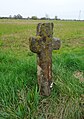 A Latin wayside cross in Roussard sandstone.
 -
 A cross from the Santiago de Compostela pilgrimage.
 -
 The castle mound in the hamlet of Vaux.
 -
 The Notre-Dame-des-Bois chapel.


.JPG)
See also
References
- ^ "Répertoire national des élus: les maires". data.gouv.fr, Plateforme ouverte des données publiques françaises (in French). 2 December 2020.
- ^ "Populations légales 2021" (in French). The National Institute of Statistics and Economic Studies. 28 December 2023.
- ^ Saugrain, Claude-Marin (1726). Dictionnaire universel de la France ancienne et moderne et de la Nouvelle France (in French). Vol. 2. p. 633.
- ^ Des villages de Cassini aux communes d'aujourd'hui: Commune data sheet Moncé-en-Belin, EHESS (in French).
- ^ Commune de Moncé-en-Belin (72200), INSEE
- ^ a b c Des villages de Cassini aux communes d'aujourd'hui: Commune data sheet Moncé-en-Belin, EHESS (in French).
- ^ Population en historique depuis 1968, INSEE
- ^ Base Palissy: Autel, tabernacle, retable, tableau : La Déposition de croix, 2 statues : Saint Etienne, Saint Jean-Baptiste, Ministère français de la Culture. (in French)
- ^ Base Palissy: Peinture monumentale : La Dormition de la Vierge, Ministère français de la Culture. (in French)
Places adjacent to Moncé-en-Belin | |
|---|---|
|
| This Sarthe geographical article is a stub. You can help Wikipedia by expanding it. |
Moncé-en-Belin | |
|---|---|
|
The church of Saint-Étienne, in Moncé-en-Belin | |
|
Coat of arms | |
Moncé-en-Belin Moncé-en-Belin | |
| Coordinates: 47°53′43″N 0°11′56″E / 47.8953°N 0.1989°E | |
| Country | France |
| Region | Pays de la Loire |
| Department | Sarthe |
| Arrondissement | Le Mans |
| Canton | Écommoy |
| Intercommunality | CC de l'Orée de Bercé Bélinois |
| Government | |
| • Mayor (2020–2026) | Irène Boyer [1] |
| Area 1 | 17.49 km2 (6.75 sq mi) |
| Population (2021)
[2] | 3,675 |
| • Density | 210/km2 (540/sq mi) |
| Demonym(s) | Moncéen, Moncéenne |
| Time zone | UTC+01:00 ( CET) |
| • Summer ( DST) | UTC+02:00 ( CEST) |
| INSEE/Postal code |
72200 /72230 |
| Elevation | 40–81 m (131–266 ft) |
| 1 French Land Register data, which excludes lakes, ponds, glaciers > 1 km2 (0.386 sq mi or 247 acres) and river estuaries. | |
Moncé-en-Belin is a commune in the Sarthe department in the region of Pays de la Loire in north-western France.
The commune is historically in the Haut-Maine part of the province of Maine. [3]
Toponymy
The suffix Belin expresses the belonging of the commune to the territory of Belinois.
During the French Revolution, the town bore the name of Moncé-lès-Le Mans, in reference to the nearby city of Le Mans. [4]
Geography
Moncé-en-Belin is located 12 km south of Le Mans, 10 km north-west of Écommoy, and about 8 km from the 24 Hours of Le Mans circuit. The commune is a part of the community of communes of Orée de Bercé - Belinois, [5] in southern Sarthe.
Population
| Year | Pop. | ±% p.a. |
|---|---|---|
| 1968 | 1,205 | — |
| 1975 | 1,688 | +4.93% |
| 1982 | 2,056 | +2.86% |
| 1990 | 2,257 | +1.17% |
| 1999 | 2,463 | +0.98% |
| 2009 | 3,375 | +3.20% |
| 2014 | 3,559 | +1.07% |
| 2020 | 3,669 | +0.51% |
| Source: INSEE [7] | ||
Local culture and heritage
The area around the town has several sites of notable historical value, including the following:
- Church of Saint-Étienne from the 11th century, containing a retable set, [8] a mural of the Virgin Mary, [9] a painting, and two statues, which have been given the designation of Monument historique
- Chapel of Notre-Dame-des-Bois from 1828
- War memorial
- Monument to the eight airmen (six Canadians, one English, and one Australian) who died on 23 May 1944, during World War II
- Castle mound of Vaux
- Roman camp
- Château de la Gourdinière
- Château de la Beaussonière
- Hattonnieres Castle
-
A Latin wayside cross in Roussard sandstone.
-
A cross from the Santiago de Compostela pilgrimage.
-
The castle mound in the hamlet of Vaux.
-
The Notre-Dame-des-Bois chapel.
See also
References
- ^ "Répertoire national des élus: les maires". data.gouv.fr, Plateforme ouverte des données publiques françaises (in French). 2 December 2020.
- ^ "Populations légales 2021" (in French). The National Institute of Statistics and Economic Studies. 28 December 2023.
- ^ Saugrain, Claude-Marin (1726). Dictionnaire universel de la France ancienne et moderne et de la Nouvelle France (in French). Vol. 2. p. 633.
- ^ Des villages de Cassini aux communes d'aujourd'hui: Commune data sheet Moncé-en-Belin, EHESS (in French).
- ^ Commune de Moncé-en-Belin (72200), INSEE
- ^ a b c Des villages de Cassini aux communes d'aujourd'hui: Commune data sheet Moncé-en-Belin, EHESS (in French).
- ^ Population en historique depuis 1968, INSEE
- ^ Base Palissy: Autel, tabernacle, retable, tableau : La Déposition de croix, 2 statues : Saint Etienne, Saint Jean-Baptiste, Ministère français de la Culture. (in French)
- ^ Base Palissy: Peinture monumentale : La Dormition de la Vierge, Ministère français de la Culture. (in French)
Places adjacent to Moncé-en-Belin | |
|---|---|
|
| This Sarthe geographical article is a stub. You can help Wikipedia by expanding it. |