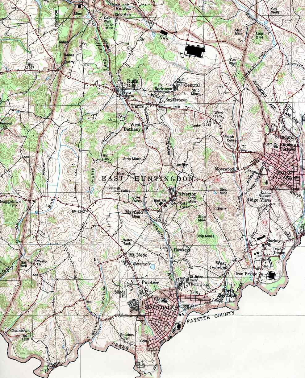
Ruffs Dale, also spelled Ruffsdale, is an unincorporated community in East Huntingdon Township, Westmoreland County, Pennsylvania United States. It is located approximately forty miles from Pittsburgh. Ruffs Dale has its own post office, with zip code 15679, located at 875 State Route 31. [1] [2]
Geography
Buffalo Run, a tributary of Sewickley Creek, runs through Ruffs Dale. [3]
In 1906, historian John Newton Boucher described Ruffs Dale as being located along "the South-West Branch of the Pennsylvania Railroad" between Hunker and "Tarr" [4] (perhaps Tarrs). In 2021, railroad tracks were still in place in Ruffs Dale. [5]
History
During the French and Indian War, the Braddock Expedition, led by General Edward Braddock and accompanied by George Washington, is said to have crossed the Big Sewickley Creek between Ruffs Dale and Paintertown, with the goal of seizing Fort Duquesne from the French. [6]
In 1896, one of the first two rural mail routes in Pennsylvania was established at the Ruffs Dale post office; the other was based in New Stanton. A historical marker was erected to commemorate the event. [7]
Industry
Mines once operated in the area around Ruffs Dale, according to a United States Geological Survey map dated 1987. [8]
The S. Dillinger & Sons distillery, which produced "Dillinger Pure Rye" whisky, was located in Ruffs Dale. [9] Constructed in 1882, it was still in operation in 1947, but was abandoned sometime prior to 1993. It was said to have been the second-largest distillery in Pennsylvania at one time. [10] [11] [12]
Education
The majority of Ruffs Dale lies within Yough School District. One school is part of Southmoreland School District.
Nearby communities
- Hunker: 3 miles
- New Stanton: 5 miles
- Mt. Pleasant: 9 miles
- Scottdale: 7 miles
- West Newton: 8 miles
- Tarrs: 4 miles
- Yukon: 4 miles
40°10′30″N 79°36′29″W / 40.17500°N 79.60806°W

| Counties |
|  | ||||||||
|---|---|---|---|---|---|---|---|---|---|---|
| Major cities | ||||||||||
| Cities and towns 15k–50k (in 2010) | ||||||||||
| Airports | ||||||||||
| Topics | ||||||||||
| International | |
|---|---|
| National | |
References
- ^ "Postmaster Finder". US Postal Service.
- ^ "Ruffs Dale - Post Office". U.S. Postal Service. Retrieved June 25, 2022.
- ^ "East Huntington Second Class Township Map" (PDF). Pennsylvania Department of Transportation. Retrieved June 25, 2022.
- ^ Boucher, John Newton (1906). History of Westmoreland County, Pennsylvania. Lewis Publishing Company. p. 283. Retrieved June 25, 2022.
- ^ Napsha, Joe. "Toys for Tots rail car caravan collects gifts to spread holiday joy". Tribune Review/TribLive. Retrieved June 25, 2022.
- ^ Boucher, John Newton (1906). History of Westmoreland County, Pennsylvania. Lewis Publishing Company. p. 6. Retrieved June 25, 2022.
- ^ Peirce, Paul. "Rural mail service got its start in Pennsylvania in New Stanton and Ruffsdale". Tribune Review (Greensburg PA). Retrieved June 25, 2022.
- ^ "Westmoreland County, Pennsylvania Township Map". U.S. Geologic Survey.
- ^ The Wine and Spirit Bulletin Volume 17. 1903. Retrieved June 25, 2022.
-
^ Muller, Edward K. and Carlisle, Ronald C.
"WESTMORELAND COUNTY, PENNSYLVANIA: An Inventory of Historic Engineering and Industrial Sites". National Park Service, U.S. Department of the Interior. pp. 242–243. Retrieved June 26, 2022.
{{
cite web}}
: CS1 maint: multiple names: authors list ( link) - ^ Pickels, Mary. "Century-old Ruffsdale distillery warehouse to be sold piece by piece". TribLive/Tribune Review. Retrieved June 25, 2022.
-
^ Napsha, Joe and Himler, Jeff.
"Prohibition thinned ranks of Western Pa. distilleries, breweries — but some survived". TribLive/Tribune Review. Retrieved June 25, 2022.
{{
cite web}}
: CS1 maint: multiple names: authors list ( link)
Ruffs Dale, also spelled Ruffsdale, is an unincorporated community in East Huntingdon Township, Westmoreland County, Pennsylvania United States. It is located approximately forty miles from Pittsburgh. Ruffs Dale has its own post office, with zip code 15679, located at 875 State Route 31. [1] [2]
Geography
Buffalo Run, a tributary of Sewickley Creek, runs through Ruffs Dale. [3]
In 1906, historian John Newton Boucher described Ruffs Dale as being located along "the South-West Branch of the Pennsylvania Railroad" between Hunker and "Tarr" [4] (perhaps Tarrs). In 2021, railroad tracks were still in place in Ruffs Dale. [5]
History
During the French and Indian War, the Braddock Expedition, led by General Edward Braddock and accompanied by George Washington, is said to have crossed the Big Sewickley Creek between Ruffs Dale and Paintertown, with the goal of seizing Fort Duquesne from the French. [6]
In 1896, one of the first two rural mail routes in Pennsylvania was established at the Ruffs Dale post office; the other was based in New Stanton. A historical marker was erected to commemorate the event. [7]
Industry
Mines once operated in the area around Ruffs Dale, according to a United States Geological Survey map dated 1987. [8]
The S. Dillinger & Sons distillery, which produced "Dillinger Pure Rye" whisky, was located in Ruffs Dale. [9] Constructed in 1882, it was still in operation in 1947, but was abandoned sometime prior to 1993. It was said to have been the second-largest distillery in Pennsylvania at one time. [10] [11] [12]
Education
The majority of Ruffs Dale lies within Yough School District. One school is part of Southmoreland School District.
Nearby communities
- Hunker: 3 miles
- New Stanton: 5 miles
- Mt. Pleasant: 9 miles
- Scottdale: 7 miles
- West Newton: 8 miles
- Tarrs: 4 miles
- Yukon: 4 miles
40°10′30″N 79°36′29″W / 40.17500°N 79.60806°W
| Counties |
| | ||||||||
|---|---|---|---|---|---|---|---|---|---|---|
| Major cities | ||||||||||
| Cities and towns 15k–50k (in 2010) | ||||||||||
| Airports | ||||||||||
| Topics | ||||||||||
| International | |
|---|---|
| National | |
References
- ^ "Postmaster Finder". US Postal Service.
- ^ "Ruffs Dale - Post Office". U.S. Postal Service. Retrieved June 25, 2022.
- ^ "East Huntington Second Class Township Map" (PDF). Pennsylvania Department of Transportation. Retrieved June 25, 2022.
- ^ Boucher, John Newton (1906). History of Westmoreland County, Pennsylvania. Lewis Publishing Company. p. 283. Retrieved June 25, 2022.
- ^ Napsha, Joe. "Toys for Tots rail car caravan collects gifts to spread holiday joy". Tribune Review/TribLive. Retrieved June 25, 2022.
- ^ Boucher, John Newton (1906). History of Westmoreland County, Pennsylvania. Lewis Publishing Company. p. 6. Retrieved June 25, 2022.
- ^ Peirce, Paul. "Rural mail service got its start in Pennsylvania in New Stanton and Ruffsdale". Tribune Review (Greensburg PA). Retrieved June 25, 2022.
- ^ "Westmoreland County, Pennsylvania Township Map". U.S. Geologic Survey.
- ^ The Wine and Spirit Bulletin Volume 17. 1903. Retrieved June 25, 2022.
-
^ Muller, Edward K. and Carlisle, Ronald C.
"WESTMORELAND COUNTY, PENNSYLVANIA: An Inventory of Historic Engineering and Industrial Sites". National Park Service, U.S. Department of the Interior. pp. 242–243. Retrieved June 26, 2022.
{{
cite web}}
: CS1 maint: multiple names: authors list ( link) - ^ Pickels, Mary. "Century-old Ruffsdale distillery warehouse to be sold piece by piece". TribLive/Tribune Review. Retrieved June 25, 2022.
-
^ Napsha, Joe and Himler, Jeff.
"Prohibition thinned ranks of Western Pa. distilleries, breweries — but some survived". TribLive/Tribune Review. Retrieved June 25, 2022.
{{
cite web}}
: CS1 maint: multiple names: authors list ( link)