Ribeira de Calhau | |
|---|---|
Settlement | |
 Beach of Calhau | |
| Coordinates: 16°50′28″N 24°54′04″W / 16.841°N 24.901°W | |
| Country | Cape Verde |
| Island | São Vicente |
| Municipality | São Vicente |
| Civil parish | Nossa Senhora da Luz |
| Elevation | 7 m (23 ft) |
| Population (2010)
[1] | |
| • Total | 1,177 |
| ID | 21105 |
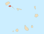
Ribeira de Calhau is a settlement in the eastern part of the island of Sao Vicente, Cape Verde. It takes its name from the river Ribeira do Calhau, and comprises the villages of Madeiral, Ribeira de Calhau and Calhau. Madeiral and Ribeira de Calhau are located in the river valley, Calhau is on the east coast. In 2010 its population was 1,177. The valley is surrounded by the mountains Viana, Madeiral, Pico do Vento and Monte Verde.
The Cape Verde Atmospheric Observatory " Humberto Duarte Fonseca" is situated 1 km north of Calhau. It is part of a German-UK initiative to undertake long-term ground- and ocean-based observations in the tropical Eastern North Atlantic Ocean region. [2]
Climate
Calhau has a hot desert climate like most of the island. The average annual temperature is 22.6 °C. Average rainfall is 129 millimeters. [3]
| Climate data for Calhau, 86 metres ASL | |||||||||||||
|---|---|---|---|---|---|---|---|---|---|---|---|---|---|
| Month | Jan | Feb | Mar | Apr | May | Jun | Jul | Aug | Sep | Oct | Nov | Dec | Year |
| Mean daily maximum °C (°F) | 23.0 (73.4) |
22.4 (72.3) |
23.2 (73.8) |
23.7 (74.7) |
24.1 (75.4) |
25.2 (77.4) |
26.7 (80.1) |
26.9 (80.4) |
26.3 (79.3) |
25.8 (78.4) |
25.8 (78.4) |
24.1 (75.4) |
24.8 (76.6) |
| Daily mean °C (°F) | 20.8 (69.4) |
20.5 (68.9) |
20.9 (69.6) |
21.3 (70.3) |
21.7 (71.1) |
23.0 (73.4) |
24.1 (75.4) |
24.7 (76.5) |
24.7 (76.5) |
24.3 (75.7) |
23.6 (74.5) |
22.1 (71.8) |
22.6 (72.7) |
| Mean daily minimum °C (°F) | 18.7 (65.7) |
18.6 (65.5) |
18.7 (65.7) |
18.9 (66.0) |
19.4 (66.9) |
20.8 (69.4) |
21.5 (70.7) |
22.6 (72.7) |
23.2 (73.8) |
22.8 (73.0) |
21.5 (70.7) |
20.2 (68.4) |
20.6 (69.1) |
| Average precipitation mm (inches) | 5 (0.2) |
1 (0.0) |
1 (0.0) |
0 (0) |
0 (0) |
0 (0) |
4 (0.2) |
19 (0.7) |
67 (2.6) |
17 (0.7) |
10 (0.4) |
5 (0.2) |
129 (5.1) |
| Source: [3] | |||||||||||||
Notable person
- Vasco Martins, singer and composer
References
- ^ "2010 Census results". Instituto Nacional de Estatística Cabo Verde (in Portuguese). 24 November 2016.
- ^ Cape Verde Atmospheric Observatory
- ^ a b Climate-Data.ORG, retrieved 12 September 2018
Ribeira de Calhau | |
|---|---|
Settlement | |
 Beach of Calhau | |
| Coordinates: 16°50′28″N 24°54′04″W / 16.841°N 24.901°W | |
| Country | Cape Verde |
| Island | São Vicente |
| Municipality | São Vicente |
| Civil parish | Nossa Senhora da Luz |
| Elevation | 7 m (23 ft) |
| Population (2010)
[1] | |
| • Total | 1,177 |
| ID | 21105 |
Ribeira de Calhau is a settlement in the eastern part of the island of Sao Vicente, Cape Verde. It takes its name from the river Ribeira do Calhau, and comprises the villages of Madeiral, Ribeira de Calhau and Calhau. Madeiral and Ribeira de Calhau are located in the river valley, Calhau is on the east coast. In 2010 its population was 1,177. The valley is surrounded by the mountains Viana, Madeiral, Pico do Vento and Monte Verde.
The Cape Verde Atmospheric Observatory " Humberto Duarte Fonseca" is situated 1 km north of Calhau. It is part of a German-UK initiative to undertake long-term ground- and ocean-based observations in the tropical Eastern North Atlantic Ocean region. [2]
Climate
Calhau has a hot desert climate like most of the island. The average annual temperature is 22.6 °C. Average rainfall is 129 millimeters. [3]
| Climate data for Calhau, 86 metres ASL | |||||||||||||
|---|---|---|---|---|---|---|---|---|---|---|---|---|---|
| Month | Jan | Feb | Mar | Apr | May | Jun | Jul | Aug | Sep | Oct | Nov | Dec | Year |
| Mean daily maximum °C (°F) | 23.0 (73.4) |
22.4 (72.3) |
23.2 (73.8) |
23.7 (74.7) |
24.1 (75.4) |
25.2 (77.4) |
26.7 (80.1) |
26.9 (80.4) |
26.3 (79.3) |
25.8 (78.4) |
25.8 (78.4) |
24.1 (75.4) |
24.8 (76.6) |
| Daily mean °C (°F) | 20.8 (69.4) |
20.5 (68.9) |
20.9 (69.6) |
21.3 (70.3) |
21.7 (71.1) |
23.0 (73.4) |
24.1 (75.4) |
24.7 (76.5) |
24.7 (76.5) |
24.3 (75.7) |
23.6 (74.5) |
22.1 (71.8) |
22.6 (72.7) |
| Mean daily minimum °C (°F) | 18.7 (65.7) |
18.6 (65.5) |
18.7 (65.7) |
18.9 (66.0) |
19.4 (66.9) |
20.8 (69.4) |
21.5 (70.7) |
22.6 (72.7) |
23.2 (73.8) |
22.8 (73.0) |
21.5 (70.7) |
20.2 (68.4) |
20.6 (69.1) |
| Average precipitation mm (inches) | 5 (0.2) |
1 (0.0) |
1 (0.0) |
0 (0) |
0 (0) |
0 (0) |
4 (0.2) |
19 (0.7) |
67 (2.6) |
17 (0.7) |
10 (0.4) |
5 (0.2) |
129 (5.1) |
| Source: [3] | |||||||||||||
Notable person
- Vasco Martins, singer and composer
References
- ^ "2010 Census results". Instituto Nacional de Estatística Cabo Verde (in Portuguese). 24 November 2016.
- ^ Cape Verde Atmospheric Observatory
- ^ a b Climate-Data.ORG, retrieved 12 September 2018

