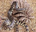
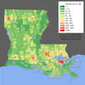
The Louisiana Portal Louisiana (French: Louisiane [lwizjan] ⓘ; Spanish: Luisiana [lwiˈsjana]; Louisiana Creole: Lwizyàn) is a state in the Deep South and South Central regions of the United States. It borders Texas to the west, Arkansas to the north, and Mississippi to the east. Of the 50 U.S. states, it ranks 20th in land area and the 25th in population, with roughly 4.6 million residents. Reflecting its French heritage, Louisiana is the only U.S. state with political subdivisions termed parishes, which are equivalent to counties, making it one of only two U.S. states not subdivided into counties (the other being Alaska and its boroughs). Baton Rouge is the state's capital, and New Orleans, a French Louisiana region, is its largest city with a population of about 383,000 people. Louisiana has a coastline with the Gulf of Mexico to the south; a large part of its eastern boundary is demarcated by the Mississippi River. Much of Louisiana's lands were formed from sediment washed down the Mississippi River, leaving enormous deltas and vast areas of coastal marsh and swamp. These contain a rich southern biota, including birds such as ibises and egrets, many species of tree frogs—such as the state recognized American green tree frog—and fish such as sturgeon and paddlefish. More elevated areas, particularly in the north, contain a wide variety of ecosystems such as tallgrass prairie, longleaf pine forest and wet savannas; these support an exceptionally large number of plant species, including many species of terrestrial orchids and carnivorous plants. Over half the state is forested. Louisiana is situated at the confluence of the Mississippi river system and the Gulf of Mexico. Its location and biodiversity attracted various indigenous groups thousands of years before Europeans arrived in the 17th century. Louisiana has eighteen Native American tribes—the most of any southern state—of which four are federally recognized and ten are state recognized. The French claimed the territory in 1682, and it became the political, commercial, and population center of the larger colony of New France. After a brief period of Spanish rule, Louisiana was returned to France in 1801 before being purchased by the U.S. in 1803; it was admitted to the Union in 1812 as the 18th state. ( Full article...) Entries here consist of
Good and
Featured articles, which meet a core set of high editorial standards.
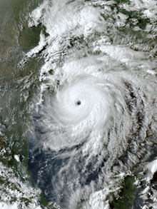
Interstate 55 (I-55) is a part of the Interstate Highway System that spans 964.25 miles (1,551.81 km) from LaPlace, Louisiana, to Chicago, Illinois. Within the state of Louisiana, the highway travels 66 miles (106 km) from the national southern terminus at I-10 in LaPlace to the Mississippi state line north of Kentwood. The route is located in the southeastern portion of Louisiana and parallels the older U.S. Highway 51 (US 51) corridor. While passing through the city of Hammond, I-55 intersects two of the state's major east–west routes, I-12 and US 190. It also serves the smaller city of Ponchatoula, as well as the towns of Amite City and Kentwood. ( Full article...)Selected article -Hurricane Laura was a deadly and destructive Category 4 hurricane that is tied with the 1856 Last Island hurricane and 2021's Hurricane Ida as the strongest hurricane on record to make landfall in the U.S. state of Louisiana, as measured by maximum sustained winds. The twelfth named storm, fourth hurricane, and first major hurricane of the record-breaking 2020 Atlantic hurricane season, Laura originated from a large tropical wave that moved off the West African coast on August 16 and became a tropical depression on August 20. Laura intensified into a tropical storm a day later, becoming the earliest twelfth named storm on record in the North Atlantic basin, forming eight days earlier than 1995's Hurricane Luis. Laura first hit the Lesser Antilles and brushed Puerto Rico as a tropical storm, then moved across the island of Hispaniola, killing 31 people in Haiti and four in the Dominican Republic. The storm then moved across the length of Cuba, prompting tropical storm warnings and the evacuation of more than 260,000 people there. Subsequently, the outer rainbands extended into the Florida Keys and South Florida. Laura then moved across the Gulf of Mexico, strengthening slowly at first, before a period of rapid intensification on August 26. That day, Laura became a major hurricane, and later attained its peak 1-minute sustained winds of 150 mph (240 km/h), making it a Category 4 hurricane. The approaching storm prompted the issuing of many warnings and watches for Louisiana, as well as the evacuation of many people. ( Full article...)General images -The following are images from various Louisiana-related articles on Wikipedia.
Did you know -
Related portalsTopicsCategoriesNew articlesThis list was generated from
these rules. Questions and feedback
are always welcome! The search is being run daily with the most recent ~14 days of results. Note: Some articles may not be relevant to this project.
Rules | Match log | Results page (for watching) | Last updated: 2024-04-27 20:51 (UTC) Note: The list display can now be customized by each user. See List display personalization for details.
WikiProjectsTasks
Associated WikimediaThe following Wikimedia Foundation sister projects provide more on this subject:
SourcesDiscover Wikipedia using
portals |
The Louisiana Portal Louisiana (French: Louisiane [lwizjan] ⓘ; Spanish: Luisiana [lwiˈsjana]; Louisiana Creole: Lwizyàn) is a state in the Deep South and South Central regions of the United States. It borders Texas to the west, Arkansas to the north, and Mississippi to the east. Of the 50 U.S. states, it ranks 20th in land area and the 25th in population, with roughly 4.6 million residents. Reflecting its French heritage, Louisiana is the only U.S. state with political subdivisions termed parishes, which are equivalent to counties, making it one of only two U.S. states not subdivided into counties (the other being Alaska and its boroughs). Baton Rouge is the state's capital, and New Orleans, a French Louisiana region, is its largest city with a population of about 383,000 people. Louisiana has a coastline with the Gulf of Mexico to the south; a large part of its eastern boundary is demarcated by the Mississippi River. Much of Louisiana's lands were formed from sediment washed down the Mississippi River, leaving enormous deltas and vast areas of coastal marsh and swamp. These contain a rich southern biota, including birds such as ibises and egrets, many species of tree frogs—such as the state recognized American green tree frog—and fish such as sturgeon and paddlefish. More elevated areas, particularly in the north, contain a wide variety of ecosystems such as tallgrass prairie, longleaf pine forest and wet savannas; these support an exceptionally large number of plant species, including many species of terrestrial orchids and carnivorous plants. Over half the state is forested. Louisiana is situated at the confluence of the Mississippi river system and the Gulf of Mexico. Its location and biodiversity attracted various indigenous groups thousands of years before Europeans arrived in the 17th century. Louisiana has eighteen Native American tribes—the most of any southern state—of which four are federally recognized and ten are state recognized. The French claimed the territory in 1682, and it became the political, commercial, and population center of the larger colony of New France. After a brief period of Spanish rule, Louisiana was returned to France in 1801 before being purchased by the U.S. in 1803; it was admitted to the Union in 1812 as the 18th state. ( Full article...) Entries here consist of
Good and
Featured articles, which meet a core set of high editorial standards.
Interstate 55 (I-55) is a part of the Interstate Highway System that spans 964.25 miles (1,551.81 km) from LaPlace, Louisiana, to Chicago, Illinois. Within the state of Louisiana, the highway travels 66 miles (106 km) from the national southern terminus at I-10 in LaPlace to the Mississippi state line north of Kentwood. The route is located in the southeastern portion of Louisiana and parallels the older U.S. Highway 51 (US 51) corridor. While passing through the city of Hammond, I-55 intersects two of the state's major east–west routes, I-12 and US 190. It also serves the smaller city of Ponchatoula, as well as the towns of Amite City and Kentwood. ( Full article...)Selected article -Hurricane Laura was a deadly and destructive Category 4 hurricane that is tied with the 1856 Last Island hurricane and 2021's Hurricane Ida as the strongest hurricane on record to make landfall in the U.S. state of Louisiana, as measured by maximum sustained winds. The twelfth named storm, fourth hurricane, and first major hurricane of the record-breaking 2020 Atlantic hurricane season, Laura originated from a large tropical wave that moved off the West African coast on August 16 and became a tropical depression on August 20. Laura intensified into a tropical storm a day later, becoming the earliest twelfth named storm on record in the North Atlantic basin, forming eight days earlier than 1995's Hurricane Luis. Laura first hit the Lesser Antilles and brushed Puerto Rico as a tropical storm, then moved across the island of Hispaniola, killing 31 people in Haiti and four in the Dominican Republic. The storm then moved across the length of Cuba, prompting tropical storm warnings and the evacuation of more than 260,000 people there. Subsequently, the outer rainbands extended into the Florida Keys and South Florida. Laura then moved across the Gulf of Mexico, strengthening slowly at first, before a period of rapid intensification on August 26. That day, Laura became a major hurricane, and later attained its peak 1-minute sustained winds of 150 mph (240 km/h), making it a Category 4 hurricane. The approaching storm prompted the issuing of many warnings and watches for Louisiana, as well as the evacuation of many people. ( Full article...)General images -The following are images from various Louisiana-related articles on Wikipedia.
Did you know -
Related portalsTopicsCategoriesNew articlesThis list was generated from
these rules. Questions and feedback
are always welcome! The search is being run daily with the most recent ~14 days of results. Note: Some articles may not be relevant to this project.
Rules | Match log | Results page (for watching) | Last updated: 2024-04-27 20:51 (UTC) Note: The list display can now be customized by each user. See List display personalization for details.
WikiProjectsTasks
Associated WikimediaThe following Wikimedia Foundation sister projects provide more on this subject:
SourcesDiscover Wikipedia using
portals |


