Photos • Location


Poppenricht | |
|---|---|
 Lutheran Church of Saint Michael | |
 Flag  Coat of arms | |
Location of Poppenricht within Amberg-Sulzbach district 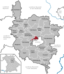 | |
 Poppenricht  Poppenricht | |
| Coordinates: 49°28′32″N 11°47′58″E / 49.47556°N 11.79944°E | |
| Country | Germany |
| State | Bavaria |
| Admin. region | Oberpfalz |
| District | Amberg-Sulzbach |
| Subdivisions | 9 Ortsteile |
| Government | |
| • Mayor (2021–27) | Hermann Böhm [1] ( CSU) |
| Area | |
| • Total | 11.58 km2 (4.47 sq mi) |
| Elevation | 406 m (1,332 ft) |
| Population (2022-12-31)
[2] | |
| • Total | 3,384 |
| • Density | 290/km2 (760/sq mi) |
| Time zone | UTC+01:00 ( CET) |
| • Summer ( DST) | UTC+02:00 ( CEST) |
| Postal codes | 92284 |
| Dialling codes | 09621 |
| Vehicle registration | AS |
| Website | www.poppenricht.de |
Poppenricht is a municipality in the district of Amberg-Sulzbach in Bavaria in Germany.
Geography
Apart from Poppenricht the municipality consists of the following villages: [3]
- Altmannshof
- Häringlohe
- Laubmühle
- Speckshof
- Traßlberg
- Wirnsricht
- Witzlhof
Twin towns
Notable people
References
- ^ Liste der ersten Bürgermeister/Oberbürgermeister in kreisangehörigen Gemeinden, Bayerisches Landesamt für Statistik, accessed 19 July 2021.
- ^ Genesis Online-Datenbank des Bayerischen Landesamtes für Statistik Tabelle 12411-003r Fortschreibung des Bevölkerungsstandes: Gemeinden, Stichtag (Einwohnerzahlen auf Grundlage des Zensus 2011).
- ^ "Ortsteile mit Postleitzahl". Retrieved 2024-02-15.
Wikimedia Commons has media related to
Poppenricht.
Towns and municipalities in
Amberg-Sulzbach | ||
|---|---|---|
|  | |
| International | |
|---|---|
| National | |
|
| This Amberg-Sulzbach location article is a stub. You can help Wikipedia by expanding it. |
Poppenricht | |
|---|---|
|
Lutheran Church of Saint Michael | |
|
Flag Coat of arms | |
Location of Poppenricht within Amberg-Sulzbach district | |
Poppenricht Poppenricht | |
| Coordinates: 49°28′32″N 11°47′58″E / 49.47556°N 11.79944°E | |
| Country | Germany |
| State | Bavaria |
| Admin. region | Oberpfalz |
| District | Amberg-Sulzbach |
| Subdivisions | 9 Ortsteile |
| Government | |
| • Mayor (2021–27) | Hermann Böhm [1] ( CSU) |
| Area | |
| • Total | 11.58 km2 (4.47 sq mi) |
| Elevation | 406 m (1,332 ft) |
| Population (2022-12-31)
[2] | |
| • Total | 3,384 |
| • Density | 290/km2 (760/sq mi) |
| Time zone | UTC+01:00 ( CET) |
| • Summer ( DST) | UTC+02:00 ( CEST) |
| Postal codes | 92284 |
| Dialling codes | 09621 |
| Vehicle registration | AS |
| Website | www.poppenricht.de |
Poppenricht is a municipality in the district of Amberg-Sulzbach in Bavaria in Germany.
Geography
Apart from Poppenricht the municipality consists of the following villages: [3]
- Altmannshof
- Häringlohe
- Laubmühle
- Speckshof
- Traßlberg
- Wirnsricht
- Witzlhof
Twin towns
Notable people
References
- ^ Liste der ersten Bürgermeister/Oberbürgermeister in kreisangehörigen Gemeinden, Bayerisches Landesamt für Statistik, accessed 19 July 2021.
- ^ Genesis Online-Datenbank des Bayerischen Landesamtes für Statistik Tabelle 12411-003r Fortschreibung des Bevölkerungsstandes: Gemeinden, Stichtag (Einwohnerzahlen auf Grundlage des Zensus 2011).
- ^ "Ortsteile mit Postleitzahl". Retrieved 2024-02-15.
Wikimedia Commons has media related to
Poppenricht.
Towns and municipalities in
Amberg-Sulzbach | ||
|---|---|---|
| | |
| International | |
|---|---|
| National | |
|
| This Amberg-Sulzbach location article is a stub. You can help Wikipedia by expanding it. |