Photos • Location


Illschwang | |
|---|---|
 View of the central part of Illschwang | |
 Flag  Coat of arms | |
Location of Illschwang within Amberg-Sulzbach district 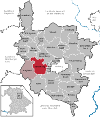 | |
 Illschwang  Illschwang | |
| Coordinates: 49°27′N 11°41′E / 49.450°N 11.683°E | |
| Country | Germany |
| State | Bavaria |
| Admin. region | Oberpfalz |
| District | Amberg-Sulzbach |
| Municipal assoc. | Illschwang |
| Government | |
| • Mayor (2020–26) | Dieter Dehling [1] ( CSU) |
| Area | |
| • Total | 54.15 km2 (20.91 sq mi) |
| Elevation | 488 m (1,601 ft) |
| Population (2022-12-31)
[2] | |
| • Total | 2,060 |
| • Density | 38/km2 (99/sq mi) |
| Time zone | UTC+01:00 ( CET) |
| • Summer ( DST) | UTC+02:00 ( CEST) |
| Postal codes | 92278 |
| Dialling codes | 09666 |
| Vehicle registration | AS |
| Website | www.illschwang.de |
Illschwang is a municipality in the district of Amberg-Sulzbach in Bavaria in Germany.
Geography
Apart from Illschwang the municipality consists of the following villages: [3]
- Aichazandt
- Altensee
- Angfeld
- Augsberg
- Bachetsfeld
- Bodenhof
- Dietersberg
- Einsricht
- Frankenhof
- Gehrsricht
- Götzendorf
- Haar
- Hackern
- Hermannsberg
- Hermannsdorf
- Kühnhof
- Mörswinkl
- Neuöd
- Ödputzberg
- Ottmannsfeld
- Pesensricht
- Pfaffenhof
- Pürschläg
- Reichertsfeld
- Ritzelsdorf
- Ritzenfeld
- Schöpfendorf
- Schwand
- Seibertshof
- Wirsfeld
- Woffenricht
Notable people
References
- ^ Liste der ersten Bürgermeister/Oberbürgermeister in kreisangehörigen Gemeinden, Bayerisches Landesamt für Statistik, 15 July 2021.
- ^ Genesis Online-Datenbank des Bayerischen Landesamtes für Statistik Tabelle 12411-003r Fortschreibung des Bevölkerungsstandes: Gemeinden, Stichtag (Einwohnerzahlen auf Grundlage des Zensus 2011).
- ^ "Ortsteile mit Postleitzahl". Retrieved 2024-02-15.
Wikimedia Commons has media related to
Illschwang.
Towns and municipalities in
Amberg-Sulzbach | ||
|---|---|---|
|  | |
| International | |
|---|---|
| National | |
| Geographic | |
|
| This Amberg-Sulzbach location article is a stub. You can help Wikipedia by expanding it. |
Illschwang | |
|---|---|
|
View of the central part of Illschwang | |
|
Flag Coat of arms | |
Location of Illschwang within Amberg-Sulzbach district | |
Illschwang Illschwang | |
| Coordinates: 49°27′N 11°41′E / 49.450°N 11.683°E | |
| Country | Germany |
| State | Bavaria |
| Admin. region | Oberpfalz |
| District | Amberg-Sulzbach |
| Municipal assoc. | Illschwang |
| Government | |
| • Mayor (2020–26) | Dieter Dehling [1] ( CSU) |
| Area | |
| • Total | 54.15 km2 (20.91 sq mi) |
| Elevation | 488 m (1,601 ft) |
| Population (2022-12-31)
[2] | |
| • Total | 2,060 |
| • Density | 38/km2 (99/sq mi) |
| Time zone | UTC+01:00 ( CET) |
| • Summer ( DST) | UTC+02:00 ( CEST) |
| Postal codes | 92278 |
| Dialling codes | 09666 |
| Vehicle registration | AS |
| Website | www.illschwang.de |
Illschwang is a municipality in the district of Amberg-Sulzbach in Bavaria in Germany.
Geography
Apart from Illschwang the municipality consists of the following villages: [3]
- Aichazandt
- Altensee
- Angfeld
- Augsberg
- Bachetsfeld
- Bodenhof
- Dietersberg
- Einsricht
- Frankenhof
- Gehrsricht
- Götzendorf
- Haar
- Hackern
- Hermannsberg
- Hermannsdorf
- Kühnhof
- Mörswinkl
- Neuöd
- Ödputzberg
- Ottmannsfeld
- Pesensricht
- Pfaffenhof
- Pürschläg
- Reichertsfeld
- Ritzelsdorf
- Ritzenfeld
- Schöpfendorf
- Schwand
- Seibertshof
- Wirsfeld
- Woffenricht
Notable people
References
- ^ Liste der ersten Bürgermeister/Oberbürgermeister in kreisangehörigen Gemeinden, Bayerisches Landesamt für Statistik, 15 July 2021.
- ^ Genesis Online-Datenbank des Bayerischen Landesamtes für Statistik Tabelle 12411-003r Fortschreibung des Bevölkerungsstandes: Gemeinden, Stichtag (Einwohnerzahlen auf Grundlage des Zensus 2011).
- ^ "Ortsteile mit Postleitzahl". Retrieved 2024-02-15.
Wikimedia Commons has media related to
Illschwang.
Towns and municipalities in
Amberg-Sulzbach | ||
|---|---|---|
| | |
| International | |
|---|---|
| National | |
| Geographic | |
|
| This Amberg-Sulzbach location article is a stub. You can help Wikipedia by expanding it. |