Photos • Location
Pangua Canton | |
|---|---|
 Pangua Canton in Cotopaxi Province | |
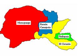
 Parishes of Pangua Canton | |
| Coordinates: 01°08′0″S 79°04′0″W / 1.13333°S 79.06667°W | |
| Country | |
| Province | Cotopaxi Province |
| Capital | El Corazón |
| Area | |
| • Total | 720.4 km2 (278.1 sq mi) |
| Population (2022 census)
[1] | |
| • Total | 21,867 |
| • Density | 30/km2 (79/sq mi) |
| Time zone | UTC-5 ( ECT) |
Pangua Canton is a canton of Ecuador, located in the Cotopaxi Province. Its capital is the town of El Corazón. Its population at the 2001 census was 19,877. [2]
Demographics
Ethnic groups as of the Ecuadorian census of 2010: [3]
- Mestizo 76.8%
- Indigenous 10.0%
- Montubio 8.8%
- White 2.8%
- Afro-Ecuadorian 1.5%
- Other 0.1%
References
- ^ Citypopulation.de Population and area of Pangua Canton
- ^ Cantons of Ecuador at statoids.com
- ^ "Resultados".
Pangua Canton | |
|---|---|
 Pangua Canton in Cotopaxi Province | |
 Parishes of Pangua Canton | |
| Coordinates: 01°08′0″S 79°04′0″W / 1.13333°S 79.06667°W | |
| Country | |
| Province | Cotopaxi Province |
| Capital | El Corazón |
| Area | |
| • Total | 720.4 km2 (278.1 sq mi) |
| Population (2022 census)
[1] | |
| • Total | 21,867 |
| • Density | 30/km2 (79/sq mi) |
| Time zone | UTC-5 ( ECT) |
Pangua Canton is a canton of Ecuador, located in the Cotopaxi Province. Its capital is the town of El Corazón. Its population at the 2001 census was 19,877. [2]
Demographics
Ethnic groups as of the Ecuadorian census of 2010: [3]
- Mestizo 76.8%
- Indigenous 10.0%
- Montubio 8.8%
- White 2.8%
- Afro-Ecuadorian 1.5%
- Other 0.1%
References
- ^ Citypopulation.de Population and area of Pangua Canton
- ^ Cantons of Ecuador at statoids.com
- ^ "Resultados".