Photos • Location
Manta Canton | |
|---|---|
 Location of Manabí Province in Ecuador. | |
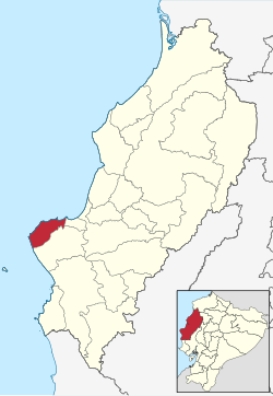
 Manta Canton in Manabí Province | |
| Coordinates: 00°57′00.08″S 80°42′58.32″W / 0.9500222°S 80.7162000°W | |
| Country | |
| Province | Manabí Province |
| Area | |
| • Total | 296.3 km2 (114.4 sq mi) |
| Population (2022 census)
[1] | |
| • Total | 271,145 |
| • Density | 920/km2 (2,400/sq mi) |
| Time zone | UTC-5 ( ECT) |
Manta Canton is a canton of Ecuador, located in the Manabí Province. Its capital is the city of Manta. Its population at the 2001 census was 192,322. [2]
Demographics
Ethnic groups as of the Ecuadorian census of 2010: [3]
- Mestizo 76.4%
- White 7.8%
- Afro-Ecuadorian 7.8%
- Montubio 7.2%
- Indigenous 0.2%
- Other 0.6%
See also
References
- ^ Citypopulation.de Population and area of Manta Canton
- ^ Cantons of Ecuador at statoids.com
- ^ "Resultados".
Manta Canton | |
|---|---|
 Location of Manabí Province in Ecuador. | |
 Manta Canton in Manabí Province | |
| Coordinates: 00°57′00.08″S 80°42′58.32″W / 0.9500222°S 80.7162000°W | |
| Country | |
| Province | Manabí Province |
| Area | |
| • Total | 296.3 km2 (114.4 sq mi) |
| Population (2022 census)
[1] | |
| • Total | 271,145 |
| • Density | 920/km2 (2,400/sq mi) |
| Time zone | UTC-5 ( ECT) |
Manta Canton is a canton of Ecuador, located in the Manabí Province. Its capital is the city of Manta. Its population at the 2001 census was 192,322. [2]
Demographics
Ethnic groups as of the Ecuadorian census of 2010: [3]
- Mestizo 76.4%
- White 7.8%
- Afro-Ecuadorian 7.8%
- Montubio 7.2%
- Indigenous 0.2%
- Other 0.6%
See also
References
- ^ Citypopulation.de Population and area of Manta Canton
- ^ Cantons of Ecuador at statoids.com
- ^ "Resultados".