Nunhem
Nunem (
Limburgish) | |
|---|---|
Village | |
 St Servatius Church | |
 Nunhem Location in the Netherlands  Nunhem Location in the province of Limburg in the Netherlands | |
| Coordinates: 51°14′40″N 5°57′40″E / 51.24444°N 5.96111°E | |
| Country | Netherlands |
| Province | Limburg |
| Municipality | Leudal |
| Area | |
| • Total | 4.37 km2 (1.69 sq mi) |
| Elevation | 22 m (72 ft) |
| Population (2021)
[1] | |
| • Total | 660 |
| • Density | 150/km2 (390/sq mi) |
| Time zone | UTC+1 ( CET) |
| • Summer ( DST) | UTC+2 ( CEST) |
| Postal code | 6083
[1] |
| Dialing code | 0475 |
| Major roads | N273 |
Nunhem ( Limburgish: Nunem) is a village in the Dutch province of Limburg. It is located in the municipality of Leudal, 1 km north of Haelen. [3]
History
The village was first mentioned in 1306 as Nunhem, and means "new settlement". [4] Nunhem developed along the Haelense Beek. [5]
The Catholic St Servatius Church is a single aisled church. The tower dates from the 14th century and was probably enlarged in the 18th century. The church was built in 1893 in Gothic Revival style. [5] The St Servatius Chapel is a site of pilgrimage. There is a well behind the chapel which, according to legend, was dug by Servatius of Tongeren and used to baptise people. [6]
Huis Nunhem is a manor house which was first attested in 1458. In the early-18th century, the current house was built which was remodelled in 1778 and corner towers were added. The estate burnt down in 1947 and restored in 1999. [5]
Nunhem was home to 166 people in 1840. [6]
Gallery
-
 Former town hall
 -
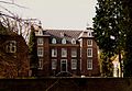 Huis Nunhem
 -
 Farm Niënghoor
 -
 Former monastery Sint Elisabethdal (1968)


References
- ^ a b c "Kerncijfers wijken en buurten 2021". Central Bureau of Statistics. Retrieved 24 April 2022.
- ^ "Postcodetool for 6083AA". Actueel Hoogtebestand Nederland (in Dutch). Het Waterschapshuis. Retrieved 24 April 2022.
- ^ Ad van der Meer and Onno Boonstra, Repertorium van Nederlandse gemeenten, KNAW, 2011.
- ^ "Nunhem - (geografische naam)". Etymologiebank (in Dutch). Retrieved 24 April 2022.
- ^ a b c Sabine Broekhoven, & Ronald Stenvert (2003). Nunhem (in Dutch). Zwolle: Waanders. ISBN 90 400 9623 6. Retrieved 24 April 2022.
- ^ a b "Nunhem". Plaatsengids (in Dutch). Retrieved 24 April 2022.
|
| This Dutch Limburg location article is a stub. You can help Wikipedia by expanding it. |
Nunhem
Nunem (
Limburgish) | |
|---|---|
Village | |
|
St Servatius Church | |
Nunhem Location in the Netherlands Nunhem Location in the province of Limburg in the Netherlands | |
| Coordinates: 51°14′40″N 5°57′40″E / 51.24444°N 5.96111°E | |
| Country | Netherlands |
| Province | Limburg |
| Municipality | Leudal |
| Area | |
| • Total | 4.37 km2 (1.69 sq mi) |
| Elevation | 22 m (72 ft) |
| Population (2021)
[1] | |
| • Total | 660 |
| • Density | 150/km2 (390/sq mi) |
| Time zone | UTC+1 ( CET) |
| • Summer ( DST) | UTC+2 ( CEST) |
| Postal code | 6083
[1] |
| Dialing code | 0475 |
| Major roads | N273 |
Nunhem ( Limburgish: Nunem) is a village in the Dutch province of Limburg. It is located in the municipality of Leudal, 1 km north of Haelen. [3]
History
The village was first mentioned in 1306 as Nunhem, and means "new settlement". [4] Nunhem developed along the Haelense Beek. [5]
The Catholic St Servatius Church is a single aisled church. The tower dates from the 14th century and was probably enlarged in the 18th century. The church was built in 1893 in Gothic Revival style. [5] The St Servatius Chapel is a site of pilgrimage. There is a well behind the chapel which, according to legend, was dug by Servatius of Tongeren and used to baptise people. [6]
Huis Nunhem is a manor house which was first attested in 1458. In the early-18th century, the current house was built which was remodelled in 1778 and corner towers were added. The estate burnt down in 1947 and restored in 1999. [5]
Nunhem was home to 166 people in 1840. [6]
Gallery
-
Former town hall
-
Huis Nunhem
-
Farm Niënghoor
-
Former monastery Sint Elisabethdal (1968)
References
- ^ a b c "Kerncijfers wijken en buurten 2021". Central Bureau of Statistics. Retrieved 24 April 2022.
- ^ "Postcodetool for 6083AA". Actueel Hoogtebestand Nederland (in Dutch). Het Waterschapshuis. Retrieved 24 April 2022.
- ^ Ad van der Meer and Onno Boonstra, Repertorium van Nederlandse gemeenten, KNAW, 2011.
- ^ "Nunhem - (geografische naam)". Etymologiebank (in Dutch). Retrieved 24 April 2022.
- ^ a b c Sabine Broekhoven, & Ronald Stenvert (2003). Nunhem (in Dutch). Zwolle: Waanders. ISBN 90 400 9623 6. Retrieved 24 April 2022.
- ^ a b "Nunhem". Plaatsengids (in Dutch). Retrieved 24 April 2022.
|
| This Dutch Limburg location article is a stub. You can help Wikipedia by expanding it. |