Nellipaka | |
|---|---|
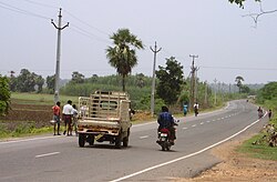
 National Highway 221(NH 221) near Nellipaka | |
|
Dynamic map | |
| Coordinates: 17°40′0″N 80°59′0″E / 17.66667°N 80.98333°E | |
| Country | |
| State | Andhra Pradesh |
| District | Alluri Sitarama Raju district |
| Languages | |
| • Official | Telugu |
| Time zone | UTC+5:30 ( IST) |
| PIN | 507129 |
| Vehicle registration | AP |
Nellipaka is a village in Alluri Sitarama Raju district of the Indian state of Andhra Pradesh. It is located in Nellipaka mandal of Rampachodavaram revenue division. Nellipaka which also produces Red chillies with an output of approximately 25 tons of chillies per acre. Nellipaka is situated at the banks of River Godavari with population around 1600 people.
Nellipaka, Alluri Sitarama Raju district. 56 kms from Bhadrachalam Railway station. [1]
It is located at 17°40′0″N 80°59′0″E / 17.66667°N 80.98333°E.
Nellipaka is connected to Vijayawada by National Highway 30. It is situated 15 km from Bhadrachalam road Railway station
- ^ "East Godavari district gets new revenue division". The Hindu. 25 March 2015. Retrieved 20 June 2016.
Nellipaka | |
|---|---|
 National Highway 221(NH 221) near Nellipaka | |
|
Dynamic map | |
| Coordinates: 17°40′0″N 80°59′0″E / 17.66667°N 80.98333°E | |
| Country | |
| State | Andhra Pradesh |
| District | Alluri Sitarama Raju district |
| Languages | |
| • Official | Telugu |
| Time zone | UTC+5:30 ( IST) |
| PIN | 507129 |
| Vehicle registration | AP |
Nellipaka is a village in Alluri Sitarama Raju district of the Indian state of Andhra Pradesh. It is located in Nellipaka mandal of Rampachodavaram revenue division. Nellipaka which also produces Red chillies with an output of approximately 25 tons of chillies per acre. Nellipaka is situated at the banks of River Godavari with population around 1600 people.
Nellipaka, Alluri Sitarama Raju district. 56 kms from Bhadrachalam Railway station. [1]
It is located at 17°40′0″N 80°59′0″E / 17.66667°N 80.98333°E.
Nellipaka is connected to Vijayawada by National Highway 30. It is situated 15 km from Bhadrachalam road Railway station
- ^ "East Godavari district gets new revenue division". The Hindu. 25 March 2015. Retrieved 20 June 2016.
