Nad Ali
نادعلی | |
|---|---|
District | |
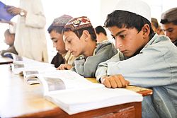
 Students during a lesson at Nad e Ali Central School in Helmand. | |
| Coordinates: 31°38′N 64°14′E / 31.64°N 64.24°E | |
| Country | |
| Province | Helmand Province |
| Population (2012)
[1] | |
| • Total | 88,600 |
Nad Ali or Nad-e Ali is a district in Helmand Province, Afghanistan. [2] Marja is an unincorporated agricultural district in Nad Ali. The area is irrigated by the Helmand and Arghandab Valley Authority (HAVA). [3] A small town of the same name lies 11 km to the west of the Helmand River, at the coordinates shown at the top of the page. The town of Nad-e Ali was built in 1954 as part of the HAVA irrigation project, and was settled by 3,000 predominantly Pashtun families who were given newly arable land. [4]
The village of Shin Kalay has made advances in the education of children that was recognized and published by the United Nations Office for the Coordination of Humanitarian Affairs ( UNOCHA).
War in Afghanistan (2001–2021)
During the International Security Assistance Force occupation, Nad Ali was in the UK area of responsibility. On 9 February 2011, soldiers from the Parachute Regiment were patrolling in north of Nad-e Ali district when they were hit by small arms fire, resulting in two fatalities. [5]
Nad Ali was the scene of several intense firefights during the course of the war in Afghanistan.
In 2014, a patrol formed of soldiers from the Household Cavalry Regiment, and the 1st Light Armored Reconnaissance Battalion were involved in a 40 hour long gunfight with Taliban fighters in and around the town.
References
- ^ "Settled Population of Helmand Province" (PDF). Central Statistics Organization. Retrieved 15 December 2015.
- ^ "District Profile" (PDF). UNHCR. Archived from the original (PDF) on 27 October 2005. Retrieved 3 August 2006.
- ^ The Helmand Valley Project in Afghanistan: AID Evaluation Special Study No. 18 C. Clapp-Wicek & E. Baldwin, US Agency for International Development, published December 1983 (pdf)
- ^ Dupree, Louis (1997). Afghanistan (2nd ed.). Oxford Pakistan Paperbacks. p. 503. ISBN 978-0-19-577634-8.
- ^ Two soldiers from Parachute Regiment die in Helmand, The Guardian, 9 February 2011
External links
- District Profile UNHCR, 2002
Nad Ali
نادعلی | |
|---|---|
District | |
 Students during a lesson at Nad e Ali Central School in Helmand. | |
| Coordinates: 31°38′N 64°14′E / 31.64°N 64.24°E | |
| Country | |
| Province | Helmand Province |
| Population (2012)
[1] | |
| • Total | 88,600 |
Nad Ali or Nad-e Ali is a district in Helmand Province, Afghanistan. [2] Marja is an unincorporated agricultural district in Nad Ali. The area is irrigated by the Helmand and Arghandab Valley Authority (HAVA). [3] A small town of the same name lies 11 km to the west of the Helmand River, at the coordinates shown at the top of the page. The town of Nad-e Ali was built in 1954 as part of the HAVA irrigation project, and was settled by 3,000 predominantly Pashtun families who were given newly arable land. [4]
The village of Shin Kalay has made advances in the education of children that was recognized and published by the United Nations Office for the Coordination of Humanitarian Affairs ( UNOCHA).
War in Afghanistan (2001–2021)
During the International Security Assistance Force occupation, Nad Ali was in the UK area of responsibility. On 9 February 2011, soldiers from the Parachute Regiment were patrolling in north of Nad-e Ali district when they were hit by small arms fire, resulting in two fatalities. [5]
Nad Ali was the scene of several intense firefights during the course of the war in Afghanistan.
In 2014, a patrol formed of soldiers from the Household Cavalry Regiment, and the 1st Light Armored Reconnaissance Battalion were involved in a 40 hour long gunfight with Taliban fighters in and around the town.
References
- ^ "Settled Population of Helmand Province" (PDF). Central Statistics Organization. Retrieved 15 December 2015.
- ^ "District Profile" (PDF). UNHCR. Archived from the original (PDF) on 27 October 2005. Retrieved 3 August 2006.
- ^ The Helmand Valley Project in Afghanistan: AID Evaluation Special Study No. 18 C. Clapp-Wicek & E. Baldwin, US Agency for International Development, published December 1983 (pdf)
- ^ Dupree, Louis (1997). Afghanistan (2nd ed.). Oxford Pakistan Paperbacks. p. 503. ISBN 978-0-19-577634-8.
- ^ Two soldiers from Parachute Regiment die in Helmand, The Guardian, 9 February 2011
External links
- District Profile UNHCR, 2002

