Photos • Location
From Wikipedia, the free encyclopedia
District in Badakhshan, Afghanistan
Arghanj Khwa
ارغنج خواه | |
|---|---|
 | |
| Coordinates: 36°57′N 70°7′E / 36.950°N 70.117°E / 36.950; 70.117 | |
| Country | |
| Province | Badakhshan |
| Government | |
| • Type | District council |
| Population (2003) | |
| • Total | 12,000 |
| Time zone | UTC+04:30 ( AST) |
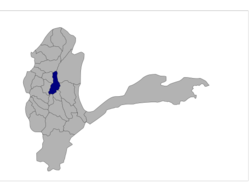
Arghanj Khwa District is a district in Badakhshan province, Afghanistan. It was created in 2005 from part of Fayzabad District. The district has a population of approximately 12,000 people. [1]
- ^ "Badakhshan Province". Afghanistan Statistical Yearbook of the Central Statistics Office, Afghanistan, accessed via Rkabuli.20m.com. Retrieved 3 January 2010.
|
| This Badakhshan Province, Afghanistan location article is a stub. You can help Wikipedia by expanding it. |
Retrieved from "
https://en.wikipedia.org/?title=Arghanj_Khwa_District&oldid=1140111944"
From Wikipedia, the free encyclopedia
District in Badakhshan, Afghanistan
Arghanj Khwa
ارغنج خواه | |
|---|---|
 | |
| Coordinates: 36°57′N 70°7′E / 36.950°N 70.117°E / 36.950; 70.117 | |
| Country | |
| Province | Badakhshan |
| Government | |
| • Type | District council |
| Population (2003) | |
| • Total | 12,000 |
| Time zone | UTC+04:30 ( AST) |
Arghanj Khwa District is a district in Badakhshan province, Afghanistan. It was created in 2005 from part of Fayzabad District. The district has a population of approximately 12,000 people. [1]
- ^ "Badakhshan Province". Afghanistan Statistical Yearbook of the Central Statistics Office, Afghanistan, accessed via Rkabuli.20m.com. Retrieved 3 January 2010.
|
| This Badakhshan Province, Afghanistan location article is a stub. You can help Wikipedia by expanding it. |
Retrieved from "
https://en.wikipedia.org/?title=Arghanj_Khwa_District&oldid=1140111944"
