Milford Square, Pennsylvania | |
|---|---|
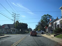
 Allentown Road at Milford Square Pike in Milford Square | |
 Location of Milford Square in
Bucks County, Pennsylvania | |
Location of Milford Square in
Pennsylvania | |
| Coordinates: 40°26′13″N 75°23′56″W / 40.43694°N 75.39889°W | |
| Country | United States |
| State | Pennsylvania |
| County | Bucks |
| Township | Milford |
| Area | |
| • Total | 0.92 sq mi (2.39 km2) |
| • Land | 0.92 sq mi (2.38 km2) |
| • Water | 0.00 sq mi (0.00 km2) |
| Population | |
| • Total | 1,137 |
| • Density | 1,234.53/sq mi (476.78/km2) |
| Time zone | UTC-5 ( Eastern (EST)) |
| • Summer ( DST) | UTC-4 (EDT) |
| ZIP Codes | 18935 and 18951 |
| Area code(s) | 215, 267 & 445 |
| FIPS code | 42-49440 |
Milford Square is a census-designated place [3] in Milford Township, Bucks County, Pennsylvania, United States. It is located along PA Route 663 near the borough of Trumbauersville. As of the 2010 census, the population was 897 residents. While the village has a PO Box post office, with the ZIP code of 18935, the surrounding area uses the Quakertown ZIP Code of 18951. [4] [5]
Milford Square is located on Unami Creek, also known as Swamp Creek, which drains into the Perkiomen Creek. It was formerly known as Heistville, named after the Heist family who operated Achey's Mill and lived in, and greatly renovated, the miller's home. [6]
Campbell's Bridge was listed on the National Register of Historic Places in 1988. [7] It is also home to Achey's Bridge, the first concrete-reinforced bridge in America, which was designed by Henry Mercer and now is located on private property.
| Census | Pop. | Note | %± |
|---|---|---|---|
| 2020 | 1,137 | — | |
| U.S. Decennial Census [8] | |||
See also
References
- ^ "ArcGIS REST Services Directory". United States Census Bureau. Retrieved October 12, 2022.
- ^ "Census Population API". United States Census Bureau. Retrieved October 12, 2022.
- ^ "2010 Census". Census.gov. Retrieved August 10, 2013.
- ^ "ZIP Code 18935, MILFORD SQUARE PA, U.S. ZIP Codes, Database - MILFORD SQUARE Pennsylvania PA Map". Zip-codes.com. Retrieved August 10, 2013.
- ^ "Quakertown Pennsylvania ZIP Code Map Free". HipCodes.com. November 30, 2012. Archived from the original on October 29, 2013. Retrieved August 10, 2013.
- ^ "History of Milford Township, Bucks County Pennsylvania". Milfordtownship.org. Retrieved August 10, 2013.
- ^ "National Register Information System". National Register of Historic Places. National Park Service. July 9, 2010.
- ^ "Census of Population and Housing". Census.gov. Retrieved June 4, 2016.
Milford Square, Pennsylvania | |
|---|---|
 Allentown Road at Milford Square Pike in Milford Square | |
 Location of Milford Square in
Bucks County, Pennsylvania | |
Location of Milford Square in
Pennsylvania | |
| Coordinates: 40°26′13″N 75°23′56″W / 40.43694°N 75.39889°W | |
| Country | United States |
| State | Pennsylvania |
| County | Bucks |
| Township | Milford |
| Area | |
| • Total | 0.92 sq mi (2.39 km2) |
| • Land | 0.92 sq mi (2.38 km2) |
| • Water | 0.00 sq mi (0.00 km2) |
| Population | |
| • Total | 1,137 |
| • Density | 1,234.53/sq mi (476.78/km2) |
| Time zone | UTC-5 ( Eastern (EST)) |
| • Summer ( DST) | UTC-4 (EDT) |
| ZIP Codes | 18935 and 18951 |
| Area code(s) | 215, 267 & 445 |
| FIPS code | 42-49440 |
Milford Square is a census-designated place [3] in Milford Township, Bucks County, Pennsylvania, United States. It is located along PA Route 663 near the borough of Trumbauersville. As of the 2010 census, the population was 897 residents. While the village has a PO Box post office, with the ZIP code of 18935, the surrounding area uses the Quakertown ZIP Code of 18951. [4] [5]
Milford Square is located on Unami Creek, also known as Swamp Creek, which drains into the Perkiomen Creek. It was formerly known as Heistville, named after the Heist family who operated Achey's Mill and lived in, and greatly renovated, the miller's home. [6]
Campbell's Bridge was listed on the National Register of Historic Places in 1988. [7] It is also home to Achey's Bridge, the first concrete-reinforced bridge in America, which was designed by Henry Mercer and now is located on private property.
| Census | Pop. | Note | %± |
|---|---|---|---|
| 2020 | 1,137 | — | |
| U.S. Decennial Census [8] | |||
See also
References
- ^ "ArcGIS REST Services Directory". United States Census Bureau. Retrieved October 12, 2022.
- ^ "Census Population API". United States Census Bureau. Retrieved October 12, 2022.
- ^ "2010 Census". Census.gov. Retrieved August 10, 2013.
- ^ "ZIP Code 18935, MILFORD SQUARE PA, U.S. ZIP Codes, Database - MILFORD SQUARE Pennsylvania PA Map". Zip-codes.com. Retrieved August 10, 2013.
- ^ "Quakertown Pennsylvania ZIP Code Map Free". HipCodes.com. November 30, 2012. Archived from the original on October 29, 2013. Retrieved August 10, 2013.
- ^ "History of Milford Township, Bucks County Pennsylvania". Milfordtownship.org. Retrieved August 10, 2013.
- ^ "National Register Information System". National Register of Historic Places. National Park Service. July 9, 2010.
- ^ "Census of Population and Housing". Census.gov. Retrieved June 4, 2016.


