Highton, Pennsylvania | |
|---|---|
Populated place | |
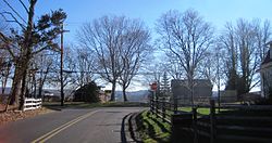
 At the intersection of Street Road and Ridge Road | |
| Coordinates: 40°19′20″N 74°59′19″W / 40.32222°N 74.98861°W | |
| Country | United States |
| State | Pennsylvania |
| County | Bucks |
| Township | Buckingham, Solebury |
| Elevation | 220 ft (67 m) |
| Time zone | UTC-5 ( Eastern (EST)) |
| • Summer ( DST) | UTC-4 (EDT) |
| Area code | 215 |
| FIPS code | 42-34668 |
| GNIS feature ID | 1203806 |
Highton is a populated place situated along the border of Buckingham and Solebury townships in Bucks County, Pennsylvania, United States. [2]
Geography
The small settlement is located along Street Road (which runs along the township line) at its intersection with Ridge Road. As the latter road's name implies, it is located along a ridge (at an estimated elevation of 220 feet (67 m) above sea level [1]) between Pidcock Creek and Curls Run, approximately three and a half miles (5.6 km) southeast of New Hope.
There are a few houses located around the settlement; the remainder consists of farms and properties containing large houses over rolling terrain. [3]
References
- ^ a b "Feature Detail Report for: Highton". Geographic Names Information System. United States Geological Survey, United States Department of the Interior.
- ^ "Highton (in Bucks County, PA) Populated Place Profile". PA Hometown Locator. Retrieved December 18, 2015.
- ^ Google (December 26, 2015). "Aerial view of Highton" (Map). Google Maps. Google. Retrieved December 26, 2015.
Highton, Pennsylvania | |
|---|---|
Populated place | |
 At the intersection of Street Road and Ridge Road | |
| Coordinates: 40°19′20″N 74°59′19″W / 40.32222°N 74.98861°W | |
| Country | United States |
| State | Pennsylvania |
| County | Bucks |
| Township | Buckingham, Solebury |
| Elevation | 220 ft (67 m) |
| Time zone | UTC-5 ( Eastern (EST)) |
| • Summer ( DST) | UTC-4 (EDT) |
| Area code | 215 |
| FIPS code | 42-34668 |
| GNIS feature ID | 1203806 |
Highton is a populated place situated along the border of Buckingham and Solebury townships in Bucks County, Pennsylvania, United States. [2]
Geography
The small settlement is located along Street Road (which runs along the township line) at its intersection with Ridge Road. As the latter road's name implies, it is located along a ridge (at an estimated elevation of 220 feet (67 m) above sea level [1]) between Pidcock Creek and Curls Run, approximately three and a half miles (5.6 km) southeast of New Hope.
There are a few houses located around the settlement; the remainder consists of farms and properties containing large houses over rolling terrain. [3]
References
- ^ a b "Feature Detail Report for: Highton". Geographic Names Information System. United States Geological Survey, United States Department of the Interior.
- ^ "Highton (in Bucks County, PA) Populated Place Profile". PA Hometown Locator. Retrieved December 18, 2015.
- ^ Google (December 26, 2015). "Aerial view of Highton" (Map). Google Maps. Google. Retrieved December 26, 2015.

