Luna, Minnesota | |
|---|---|
 Luna  Luna | |
| Coordinates: 48°15′13″N 96°47′37″W / 48.25361°N 96.79361°W | |
| Country | United States |
| State | Minnesota |
| County | Marshall |
| Township | Warrenton |
| Elevation | 853 ft (260 m) |
| Time zone | UTC-6 ( Central (CST)) |
| • Summer ( DST) | UTC-5 (CDT) |
| Area code | 218 |
| GNIS feature ID | 654807 [1] |
Luna is an unincorporated community in southern Marshall County, Minnesota, United States. [1] [2]
The community lies approximately four miles north of Warren along U.S. Route 75. [3]
Climate
According to the Köppen Climate Classification system, Luna has a warm-summer humid continental climate, abbreviated "Dfb" on climate maps. The hottest temperature recorded in Luna was 101 °F (38.3 °C) on June 1942, while the coldest temperature recorded was −32 °F (−35.6 °C) on January 22, 1937, January 18, 1960, January 30, 1979, and December 23, 1990. [4]
| Climate data for Luna, Minnesota, 1991–2020 normals, extremes 1903–2015 | |||||||||||||
|---|---|---|---|---|---|---|---|---|---|---|---|---|---|
| Month | Jan | Feb | Mar | Apr | May | Jun | Jul | Aug | Sep | Oct | Nov | Dec | Year |
| Record high °F (°C) | 72 (22) |
76 (24) |
81 (27) |
89 (32) |
96 (36) |
101 (38) |
100 (38) |
97 (36) |
97 (36) |
87 (31) |
80 (27) |
73 (23) |
101 (38) |
| Mean maximum °F (°C) | 63.3 (17.4) |
64.8 (18.2) |
70.6 (21.4) |
77.2 (25.1) |
84.3 (29.1) |
91.5 (33.1) |
92.6 (33.7) |
88.2 (31.2) |
84.6 (29.2) |
78.4 (25.8) |
70.5 (21.4) |
64.2 (17.9) |
93.7 (34.3) |
| Mean daily maximum °F (°C) | 51.9 (11.1) |
54.6 (12.6) |
60.9 (16.1) |
67.2 (19.6) |
75.4 (24.1) |
85.0 (29.4) |
85.3 (29.6) |
81.8 (27.7) |
78.5 (25.8) |
71.0 (21.7) |
60.7 (15.9) |
52.3 (11.3) |
68.7 (20.4) |
| Daily mean °F (°C) | 32.7 (0.4) |
35.6 (2.0) |
40.1 (4.5) |
45.9 (7.7) |
52.5 (11.4) |
61.2 (16.2) |
66.4 (19.1) |
64.5 (18.1) |
58.8 (14.9) |
48.8 (9.3) |
39.3 (4.1) |
32.6 (0.3) |
48.2 (9.0) |
| Mean daily minimum °F (°C) | 13.5 (−10.3) |
16.5 (−8.6) |
19.3 (−7.1) |
24.5 (−4.2) |
29.7 (−1.3) |
37.4 (3.0) |
47.5 (8.6) |
47.2 (8.4) |
39.1 (3.9) |
26.7 (−2.9) |
18.0 (−7.8) |
13.0 (−10.6) |
27.7 (−2.4) |
| Mean minimum °F (°C) | −4.6 (−20.3) |
−0.8 (−18.2) |
4.4 (−15.3) |
10.6 (−11.9) |
17.6 (−8.0) |
25.5 (−3.6) |
35.9 (2.2) |
38.0 (3.3) |
26.9 (−2.8) |
13.3 (−10.4) |
1.5 (−16.9) |
−8.4 (−22.4) |
−12.0 (−24.4) |
| Record low °F (°C) | −32 (−36) |
−31 (−35) |
−18 (−28) |
−5 (−21) |
7 (−14) |
18 (−8) |
26 (−3) |
30 (−1) |
19 (−7) |
2 (−17) |
−25 (−32) |
−32 (−36) |
−32 (−36) |
| Average precipitation inches (mm) | 1.21 (31) |
1.05 (27) |
0.82 (21) |
0.45 (11) |
0.68 (17) |
0.61 (15) |
3.37 (86) |
3.84 (98) |
2.16 (55) |
1.42 (36) |
0.86 (22) |
1.11 (28) |
17.58 (447) |
| Average snowfall inches (cm) | 5.4 (14) |
1.7 (4.3) |
1.4 (3.6) |
0.7 (1.8) |
0.0 (0.0) |
0.0 (0.0) |
0.0 (0.0) |
0.0 (0.0) |
0.0 (0.0) |
0.1 (0.25) |
1.4 (3.6) |
6.9 (18) |
17.6 (45.55) |
| Average precipitation days (≥ 0.01 in) | 5.3 | 4.7 | 4.6 | 3.2 | 3.8 | 4.0 | 15.3 | 15.4 | 8.2 | 4.9 | 3.8 | 5.0 | 78.2 |
| Average snowy days (≥ 0.1 in) | 2.4 | 1.5 | 1.3 | 0.7 | 0.0 | 0.0 | 0.0 | 0.0 | 0.0 | 0.1 | 0.7 | 2.4 | 9.1 |
| Source 1: NOAA [5] | |||||||||||||
| Source 2: XMACIS2 (mean maxima/minima 1981–2010) [4] | |||||||||||||
Notes
- ^ a b c "Luna, Minnesota". Geographic Names Information System. United States Geological Survey, United States Department of the Interior.
- ^ Minnesota Department of Transportation-Marshall County
- ^ Newfolden, MN, 7.5 Minute Topographic Quadrangle, USGS, 1982
- ^ a b "xmACIS2". National Oceanic and Atmospheric Administration. Retrieved February 21, 2023.
- ^ "U.S. Climate Normals Quick Access – Station: Luna RS, MN". National Oceanic and Atmospheric Administration. Retrieved February 21, 2023.
Municipalities and communities of
Marshall County, Minnesota, United States | ||
|---|---|---|
| Cities | 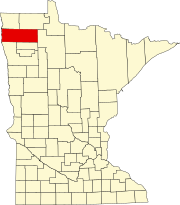 | |
| Townships |
| |
|
Unincorporated communities | ||
|
Unorganized territory | ||
|
Indian reservation | ||
| Footnotes | ‡This populated place also has portions in an adjacent county or counties | |
Luna, Minnesota | |
|---|---|
Luna Luna | |
| Coordinates: 48°15′13″N 96°47′37″W / 48.25361°N 96.79361°W | |
| Country | United States |
| State | Minnesota |
| County | Marshall |
| Township | Warrenton |
| Elevation | 853 ft (260 m) |
| Time zone | UTC-6 ( Central (CST)) |
| • Summer ( DST) | UTC-5 (CDT) |
| Area code | 218 |
| GNIS feature ID | 654807 [1] |
Luna is an unincorporated community in southern Marshall County, Minnesota, United States. [1] [2]
The community lies approximately four miles north of Warren along U.S. Route 75. [3]
Climate
According to the Köppen Climate Classification system, Luna has a warm-summer humid continental climate, abbreviated "Dfb" on climate maps. The hottest temperature recorded in Luna was 101 °F (38.3 °C) on June 1942, while the coldest temperature recorded was −32 °F (−35.6 °C) on January 22, 1937, January 18, 1960, January 30, 1979, and December 23, 1990. [4]
| Climate data for Luna, Minnesota, 1991–2020 normals, extremes 1903–2015 | |||||||||||||
|---|---|---|---|---|---|---|---|---|---|---|---|---|---|
| Month | Jan | Feb | Mar | Apr | May | Jun | Jul | Aug | Sep | Oct | Nov | Dec | Year |
| Record high °F (°C) | 72 (22) |
76 (24) |
81 (27) |
89 (32) |
96 (36) |
101 (38) |
100 (38) |
97 (36) |
97 (36) |
87 (31) |
80 (27) |
73 (23) |
101 (38) |
| Mean maximum °F (°C) | 63.3 (17.4) |
64.8 (18.2) |
70.6 (21.4) |
77.2 (25.1) |
84.3 (29.1) |
91.5 (33.1) |
92.6 (33.7) |
88.2 (31.2) |
84.6 (29.2) |
78.4 (25.8) |
70.5 (21.4) |
64.2 (17.9) |
93.7 (34.3) |
| Mean daily maximum °F (°C) | 51.9 (11.1) |
54.6 (12.6) |
60.9 (16.1) |
67.2 (19.6) |
75.4 (24.1) |
85.0 (29.4) |
85.3 (29.6) |
81.8 (27.7) |
78.5 (25.8) |
71.0 (21.7) |
60.7 (15.9) |
52.3 (11.3) |
68.7 (20.4) |
| Daily mean °F (°C) | 32.7 (0.4) |
35.6 (2.0) |
40.1 (4.5) |
45.9 (7.7) |
52.5 (11.4) |
61.2 (16.2) |
66.4 (19.1) |
64.5 (18.1) |
58.8 (14.9) |
48.8 (9.3) |
39.3 (4.1) |
32.6 (0.3) |
48.2 (9.0) |
| Mean daily minimum °F (°C) | 13.5 (−10.3) |
16.5 (−8.6) |
19.3 (−7.1) |
24.5 (−4.2) |
29.7 (−1.3) |
37.4 (3.0) |
47.5 (8.6) |
47.2 (8.4) |
39.1 (3.9) |
26.7 (−2.9) |
18.0 (−7.8) |
13.0 (−10.6) |
27.7 (−2.4) |
| Mean minimum °F (°C) | −4.6 (−20.3) |
−0.8 (−18.2) |
4.4 (−15.3) |
10.6 (−11.9) |
17.6 (−8.0) |
25.5 (−3.6) |
35.9 (2.2) |
38.0 (3.3) |
26.9 (−2.8) |
13.3 (−10.4) |
1.5 (−16.9) |
−8.4 (−22.4) |
−12.0 (−24.4) |
| Record low °F (°C) | −32 (−36) |
−31 (−35) |
−18 (−28) |
−5 (−21) |
7 (−14) |
18 (−8) |
26 (−3) |
30 (−1) |
19 (−7) |
2 (−17) |
−25 (−32) |
−32 (−36) |
−32 (−36) |
| Average precipitation inches (mm) | 1.21 (31) |
1.05 (27) |
0.82 (21) |
0.45 (11) |
0.68 (17) |
0.61 (15) |
3.37 (86) |
3.84 (98) |
2.16 (55) |
1.42 (36) |
0.86 (22) |
1.11 (28) |
17.58 (447) |
| Average snowfall inches (cm) | 5.4 (14) |
1.7 (4.3) |
1.4 (3.6) |
0.7 (1.8) |
0.0 (0.0) |
0.0 (0.0) |
0.0 (0.0) |
0.0 (0.0) |
0.0 (0.0) |
0.1 (0.25) |
1.4 (3.6) |
6.9 (18) |
17.6 (45.55) |
| Average precipitation days (≥ 0.01 in) | 5.3 | 4.7 | 4.6 | 3.2 | 3.8 | 4.0 | 15.3 | 15.4 | 8.2 | 4.9 | 3.8 | 5.0 | 78.2 |
| Average snowy days (≥ 0.1 in) | 2.4 | 1.5 | 1.3 | 0.7 | 0.0 | 0.0 | 0.0 | 0.0 | 0.0 | 0.1 | 0.7 | 2.4 | 9.1 |
| Source 1: NOAA [5] | |||||||||||||
| Source 2: XMACIS2 (mean maxima/minima 1981–2010) [4] | |||||||||||||
Notes
- ^ a b c "Luna, Minnesota". Geographic Names Information System. United States Geological Survey, United States Department of the Interior.
- ^ Minnesota Department of Transportation-Marshall County
- ^ Newfolden, MN, 7.5 Minute Topographic Quadrangle, USGS, 1982
- ^ a b "xmACIS2". National Oceanic and Atmospheric Administration. Retrieved February 21, 2023.
- ^ "U.S. Climate Normals Quick Access – Station: Luna RS, MN". National Oceanic and Atmospheric Administration. Retrieved February 21, 2023.
Municipalities and communities of
Marshall County, Minnesota, United States | ||
|---|---|---|
| Cities | | |
| Townships |
| |
|
Unincorporated communities | ||
|
Unorganized territory | ||
|
Indian reservation | ||
| Footnotes | ‡This populated place also has portions in an adjacent county or counties | |