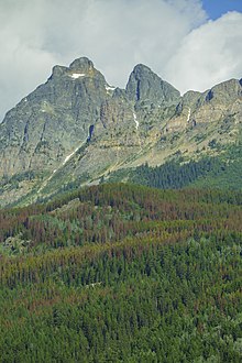
| Lucerne Peak | |
|---|---|
 South aspect | |
| Highest point | |
| Elevation | 2,412 m (7,913 ft) [1] |
| Coordinates | 52°53′00″N 118°34′30″W / 52.88333°N 118.57500°W |
| Geography | |
| Location |
Alberta British Columbia |
| Topo map | NTS 83D15 Lucerne |
Lucerne Peak is located on the border of Alberta and British Columbia; on the continental divide, and is one of the peaks of Yellowhead Mountain. It was named by Arthur O. Wheeler after the railway town located at the mountain's base. [1]
When the Canadian Northern Pacific Railway reached Yellowhead Lake in 1913, it named the station there after Lucerne, Switzerland. A small town developed. For a time it had a population approaching three hundred and rivaled Jasper. In 1924 the "railway divisional point" moved from Lucerne to Jasper and many of the residents relocated to Jasper. Lucerne's railway station was demolished after the Second World War. [1]
Climate
Based on the Köppen climate classification, Lucerne Peak is located in a subarctic climate zone with cold, snowy winters, and mild summers. [2] Winter temperatures can drop below -20 °C with wind chill factors below -30 °C.

See also
- List of peaks on the Alberta–British Columbia border
- Mountains of Alberta
- Mountains of British Columbia
References
External links
| Lucerne Peak | |
|---|---|
 South aspect | |
| Highest point | |
| Elevation | 2,412 m (7,913 ft) [1] |
| Coordinates | 52°53′00″N 118°34′30″W / 52.88333°N 118.57500°W |
| Geography | |
| Location |
Alberta British Columbia |
| Topo map | NTS 83D15 Lucerne |
Lucerne Peak is located on the border of Alberta and British Columbia; on the continental divide, and is one of the peaks of Yellowhead Mountain. It was named by Arthur O. Wheeler after the railway town located at the mountain's base. [1]
When the Canadian Northern Pacific Railway reached Yellowhead Lake in 1913, it named the station there after Lucerne, Switzerland. A small town developed. For a time it had a population approaching three hundred and rivaled Jasper. In 1924 the "railway divisional point" moved from Lucerne to Jasper and many of the residents relocated to Jasper. Lucerne's railway station was demolished after the Second World War. [1]
Climate
Based on the Köppen climate classification, Lucerne Peak is located in a subarctic climate zone with cold, snowy winters, and mild summers. [2] Winter temperatures can drop below -20 °C with wind chill factors below -30 °C.

See also
- List of peaks on the Alberta–British Columbia border
- Mountains of Alberta
- Mountains of British Columbia
References
External links
