| Saskatchewan Glacier | |
|---|---|
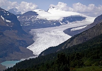
 Saskatchewan Glacier in Alberta, Canada seen from
Parker Ridge | |
 Saskatchewan Glacier  Saskatchewan Glacier  Saskatchewan Glacier | |
| Location | Alberta, Canada |
| Coordinates | 52°08′19″N 117°11′36″W / 52.138546°N 117.193222°W |
| Area | 30 square kilometres (12 sq mi) |
| Length | 13 kilometres (8 mi) |
| Status | Receding |
|
| |
The Saskatchewan Glacier is located in
Banff National Park,
Alberta,
Canada, approximately 120 km (75 mi) northwest of the town of
Banff, and can be accessed from the
Icefields Parkway. Saskatchewan Glacier is the largest outflow glacier from the
Columbia Icefield, which rests along the
Continental Divide. The glacier is a primary water source for the
North Saskatchewan River. The glacier is approximately 13 kilometres (8.1 mi) long and covers an area of 30 km2 (11.5 mi2) and was measured in 1960 to be over 400 metres (1,310 ft) thick at a distance of 8 kilometres (5.0 mi) from the terminal snout.
[1] Between the years 1893 and 1953, Saskatchewan Glacier had receded a distance of 1,364 metres (4,475 ft), with the rate of retreat between the years 1948 and 1953 averaging 55 metres (180 ft) per year.
[1] The glacier, which flows northeast, exhibits a prominent medial morraine.
[2]
See also
References
- ^ a b Ommanney, C. Simon L. Williams, Richard Jr.; Ferrigno, Jane G. (eds.). "Glaciers of the Canadian Rockies" (pdf). Satellite Image Atlas of Glaciers of the World. U.S. Geological Survey Professional Paper 1386-J-1: 248–251. Retrieved 2006-07-04.
- ^ Smith, D.G. (1987). Landforms of Alberta interpreted from airphotos and satellite imagery. Edmonton, Alberta: Alberta Remote Sensing Centre, Alberta Environment. p. 35. ISBN 0-919975-10-0.
Gallery
-
 Saskatchewan Glacier with Castleguard Mountain from Parker Ridge
 -
 Saskatchewan Glacier & Parker Ridge from glacier's toe
 -
 In this animated gif of the Columbia Icefield, glaciated areas in 1990 are compared to 2000. The Saskatchewan Glacier is the large tongue shaped glacier on the left, which has both retreated and thinned along most of its length during the period.


| International | |
|---|---|
| National | |
|
| This Alberta location article is a stub. You can help Wikipedia by expanding it. |
|
| This article about a glacier in Canada is a stub. You can help Wikipedia by expanding it. |
| Saskatchewan Glacier | |
|---|---|
|
Saskatchewan Glacier in Alberta, Canada seen from
Parker Ridge | |
Saskatchewan Glacier Saskatchewan Glacier Saskatchewan Glacier | |
| Location | Alberta, Canada |
| Coordinates | 52°08′19″N 117°11′36″W / 52.138546°N 117.193222°W |
| Area | 30 square kilometres (12 sq mi) |
| Length | 13 kilometres (8 mi) |
| Status | Receding |
|
| |
The Saskatchewan Glacier is located in
Banff National Park,
Alberta,
Canada, approximately 120 km (75 mi) northwest of the town of
Banff, and can be accessed from the
Icefields Parkway. Saskatchewan Glacier is the largest outflow glacier from the
Columbia Icefield, which rests along the
Continental Divide. The glacier is a primary water source for the
North Saskatchewan River. The glacier is approximately 13 kilometres (8.1 mi) long and covers an area of 30 km2 (11.5 mi2) and was measured in 1960 to be over 400 metres (1,310 ft) thick at a distance of 8 kilometres (5.0 mi) from the terminal snout.
[1] Between the years 1893 and 1953, Saskatchewan Glacier had receded a distance of 1,364 metres (4,475 ft), with the rate of retreat between the years 1948 and 1953 averaging 55 metres (180 ft) per year.
[1] The glacier, which flows northeast, exhibits a prominent medial morraine.
[2]
See also
References
- ^ a b Ommanney, C. Simon L. Williams, Richard Jr.; Ferrigno, Jane G. (eds.). "Glaciers of the Canadian Rockies" (pdf). Satellite Image Atlas of Glaciers of the World. U.S. Geological Survey Professional Paper 1386-J-1: 248–251. Retrieved 2006-07-04.
- ^ Smith, D.G. (1987). Landforms of Alberta interpreted from airphotos and satellite imagery. Edmonton, Alberta: Alberta Remote Sensing Centre, Alberta Environment. p. 35. ISBN 0-919975-10-0.
Gallery
-
Saskatchewan Glacier with Castleguard Mountain from Parker Ridge
-
Saskatchewan Glacier & Parker Ridge from glacier's toe
-
In this animated gif of the Columbia Icefield, glaciated areas in 1990 are compared to 2000. The Saskatchewan Glacier is the large tongue shaped glacier on the left, which has both retreated and thinned along most of its length during the period.
| International | |
|---|---|
| National | |
|
| This Alberta location article is a stub. You can help Wikipedia by expanding it. |
|
| This article about a glacier in Canada is a stub. You can help Wikipedia by expanding it. |