| Lock and Dam No. 22 | |
|---|---|
 Mississippi River Lock and Dam No. 22 | |
 Location of Lock and Dam No. 22 in Missouri | |
| Location |
Cincinnati Township,
Pike County, Illinois / Saverton Township,
Ralls County, Missouri, near Saverton, Missouri |
| Coordinates | 39°38′18″N 91°14′49″W / 39.63833°N 91.24694°W |
| Construction began | 1934 |
| Opening date | July 22, 1938 |
| Operator(s) |
|
| Dam and spillways | |
| Impounds | Upper Mississippi River |
| Length | 1,224 feet (373.1 m) (movable portion) |
| Reservoir | |
| Creates | Pool 22 |
| Total capacity | 80,000 acre⋅ft (0.099 km3) |
| Catchment area | 137,500 sq mi (356,000 km2) |
Lock and Dam No. 22 Historic District | |
 | |
| Location | Secondary Rd. E, New London, Missouri |
| Area | 126.8 acres (51.3 ha) |
| Built | 1938 |
| Architect | US Army Corps of Engineers; Abbott, Edwin E., et al. |
| MPS | Upper Mississippi River 9-Foot Navigation Project MPS |
| NRHP reference No. | 04000182 [1] |
| Added to NRHP | March 10, 2004 |
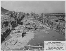
Lock and Dam No. 22 is a lock and dam located near Saverton, Missouri, on the Upper Mississippi River around river mile 301.2. The movable portion of the dam is 1,224 feet (373.1 m) long and consists of three roller gates and ten tainter gates. A 1,600 feet (487.7 m) long submersible earthen dike extends to a flood control levee on the Illinois shore. The main lock is 110 feet (33.5 m) wide by 600 feet (182.9 m) long; there is also an incomplete auxiliary lock. [2] In 2004, the facility was listed in the National Register of Historic Places as Lock and Dam No. 22 Historic District, #04000182 covering 1,268 acres (5.1 km2), 1 building, 5 structures, 4 objects.
When the northern part of Mississippi freezes, near the first week of February, upwards of 20 bald eagles fly down to fish in the churning waters below Lock and Dam No. 22.
 |

|
See also
References
- ^ "National Register Information System". National Register of Historic Places. National Park Service. July 9, 2010.
- ^ "Lock & Dam 22" (PDF). U.S. Army Corps of Engineers. Archived from the original (PDF) on January 22, 2015.
External links
![]() Media related to
Mississippi River Lock and Dam number 22 at Wikimedia Commons
Media related to
Mississippi River Lock and Dam number 22 at Wikimedia Commons
- Lock and Dam No. 22 - U.S. Army Corps of Engineers
- Historic American Engineering Record (HAER) No. MO-35, " Upper Mississippi River Nine-Foot Channel Project, Lock & Dam Complex No. 22, Upper Mississippi River, Saverton, Ralls County, MO", 21 photos, 15 data pages, 2 photo caption pages
| Topics | |
|---|---|
| Lists by state |
|
| Lists by insular areas | |
| Lists by associated state | |
| Other areas | |
| Related | |
|
| This Ralls County, Missouri state location article is a stub. You can help Wikipedia by expanding it. |
- Dams completed in 1938
- Mississippi River locks
- Dams in Missouri
- National Register of Historic Places in Ralls County, Missouri
- Locks on the National Register of Historic Places in Illinois
- United States Army Corps of Engineers dams
- Transport infrastructure completed in 1938
- Roller dams
- Gravity dams
- Dams on the Mississippi River
- Mississippi Valley Division
- Historic American Engineering Record in Illinois
- Historic American Engineering Record in Missouri
- Historic districts on the National Register of Historic Places in Missouri
- National Register of Historic Places in Pike County, Missouri
- Locks on the National Register of Historic Places in Missouri
- Dams on the National Register of Historic Places in Illinois
- Dams on the National Register of Historic Places in Missouri
- 1938 establishments in Missouri
- 1938 establishments in Illinois
- Transportation buildings and structures in Pike County, Illinois
- Northeast Missouri Registered Historic Place stubs
- Northeast Missouri geography stubs
| Lock and Dam No. 22 | |
|---|---|
|
Mississippi River Lock and Dam No. 22 | |
Location of Lock and Dam No. 22 in Missouri | |
| Location |
Cincinnati Township,
Pike County, Illinois / Saverton Township,
Ralls County, Missouri, near Saverton, Missouri |
| Coordinates | 39°38′18″N 91°14′49″W / 39.63833°N 91.24694°W |
| Construction began | 1934 |
| Opening date | July 22, 1938 |
| Operator(s) |
|
| Dam and spillways | |
| Impounds | Upper Mississippi River |
| Length | 1,224 feet (373.1 m) (movable portion) |
| Reservoir | |
| Creates | Pool 22 |
| Total capacity | 80,000 acre⋅ft (0.099 km3) |
| Catchment area | 137,500 sq mi (356,000 km2) |
Lock and Dam No. 22 Historic District | |
| |
| Location | Secondary Rd. E, New London, Missouri |
| Area | 126.8 acres (51.3 ha) |
| Built | 1938 |
| Architect | US Army Corps of Engineers; Abbott, Edwin E., et al. |
| MPS | Upper Mississippi River 9-Foot Navigation Project MPS |
| NRHP reference No. | 04000182 [1] |
| Added to NRHP | March 10, 2004 |
Lock and Dam No. 22 is a lock and dam located near Saverton, Missouri, on the Upper Mississippi River around river mile 301.2. The movable portion of the dam is 1,224 feet (373.1 m) long and consists of three roller gates and ten tainter gates. A 1,600 feet (487.7 m) long submersible earthen dike extends to a flood control levee on the Illinois shore. The main lock is 110 feet (33.5 m) wide by 600 feet (182.9 m) long; there is also an incomplete auxiliary lock. [2] In 2004, the facility was listed in the National Register of Historic Places as Lock and Dam No. 22 Historic District, #04000182 covering 1,268 acres (5.1 km2), 1 building, 5 structures, 4 objects.
When the northern part of Mississippi freezes, near the first week of February, upwards of 20 bald eagles fly down to fish in the churning waters below Lock and Dam No. 22.
|
|
See also
References
- ^ "National Register Information System". National Register of Historic Places. National Park Service. July 9, 2010.
- ^ "Lock & Dam 22" (PDF). U.S. Army Corps of Engineers. Archived from the original (PDF) on January 22, 2015.
External links
![]() Media related to
Mississippi River Lock and Dam number 22 at Wikimedia Commons
Media related to
Mississippi River Lock and Dam number 22 at Wikimedia Commons
- Lock and Dam No. 22 - U.S. Army Corps of Engineers
- Historic American Engineering Record (HAER) No. MO-35, " Upper Mississippi River Nine-Foot Channel Project, Lock & Dam Complex No. 22, Upper Mississippi River, Saverton, Ralls County, MO", 21 photos, 15 data pages, 2 photo caption pages
| Topics | |
|---|---|
| Lists by state |
|
| Lists by insular areas | |
| Lists by associated state | |
| Other areas | |
| Related | |
|
| This Ralls County, Missouri state location article is a stub. You can help Wikipedia by expanding it. |
- Dams completed in 1938
- Mississippi River locks
- Dams in Missouri
- National Register of Historic Places in Ralls County, Missouri
- Locks on the National Register of Historic Places in Illinois
- United States Army Corps of Engineers dams
- Transport infrastructure completed in 1938
- Roller dams
- Gravity dams
- Dams on the Mississippi River
- Mississippi Valley Division
- Historic American Engineering Record in Illinois
- Historic American Engineering Record in Missouri
- Historic districts on the National Register of Historic Places in Missouri
- National Register of Historic Places in Pike County, Missouri
- Locks on the National Register of Historic Places in Missouri
- Dams on the National Register of Historic Places in Illinois
- Dams on the National Register of Historic Places in Missouri
- 1938 establishments in Missouri
- 1938 establishments in Illinois
- Transportation buildings and structures in Pike County, Illinois
- Northeast Missouri Registered Historic Place stubs
- Northeast Missouri geography stubs