| Lock and Dam No. 16 | |
|---|---|
 Mississippi River Lock and Dam number 16 | |
| Location |
Sweetland Township,
Muscatine County, Iowa /
Drury Township,
Rock Island County, Illinois, near Muscatine, Iowa, USA |
| Coordinates | 41°25′37.29″N 91°0′37.75″W / 41.4270250°N 91.0104861°W |
| Construction began | 1933 |
| Opening date | July 10, 1937 |
| Operator(s) |
|
| Dam and spillways | |
| Impounds | Upper Mississippi River |
| Length | 1,315 feet (400.8 m) |
| Reservoir | |
| Creates | Pool 16 |
| Total capacity | 88,400 acre⋅ft (0.1090 km3) |
| Catchment area | 99,400 sq mi (257,000 km2) |
Lock and Dam No. 16 Historic District | |
  | |
| Location | 33109 102nd Ave. W, Muscatine, Iowa |
| Area | 102.4 acres (41.4 ha) |
| Built | 1937 |
| Architect | U.S. Army Corps of Engineers |
| MPS | Upper Mississippi River 9-Foot Navigation Project MPS |
| NRHP reference No. | 04000176 [1] |
| Added to NRHP | March 10, 2004 |
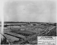
Lock and Dam No. 16 is a lock and dam located near Muscatine, Iowa on the Upper Mississippi River around river mile 457.2. The movable portion of the dam is 1,315 feet (400.8 m) long and consists of 4 roller gates and 15 Tainter gates. The lock is 110 feet (33.5 m) wide by 600 feet (182.9 m) long with a maximum lift of 9 feet (2.7m) [2] In 2004, the facility was listed in the National Register of Historic Places as Lock and Dam No. 16 Historic District, #04000176 covering 1,024 acres (4.1 km2), 1 building, 5 structures, and 2 objects.
 |

|
See also
References
- ^ "National Register Information System". National Register of Historic Places. National Park Service. July 9, 2010.
- ^ "Lock & Dam 16" (PDF). U.S. Army Corps of Engineers. Retrieved January 6, 2014.
External links
- Lock and Dam No. 16 - U.S. Army Corps of Engineers
- Historic American Engineering Record (HAER) No. IA-26, " Mississippi River 9-Foot Channel Project, Lock & Dam No. 16, Muscatine, Muscatine County, IA", 21 photos, 13 data pages, 2 photo caption pages
| Topics | |
|---|---|
| Lists by state |
|
| Lists by insular areas | |
| Lists by associated state | |
| Other areas | |
| Related | |

|
| This article about a property in Muscatine County, Iowa on the National Register of Historic Places is a stub. You can help Wikipedia by expanding it. |
- Transport infrastructure completed in 1937
- National Register of Historic Places in Muscatine County, Iowa
- Mississippi River locks
- Buildings and structures in Muscatine County, Iowa
- Locks on the National Register of Historic Places in Illinois
- Dams on the National Register of Historic Places in Iowa
- Dams on the National Register of Historic Places in Illinois
- Buildings and structures in Rock Island County, Illinois
- Roller dams
- Gravity dams
- Dams on the Mississippi River
- Mississippi Valley Division
- Historic American Engineering Record in Iowa
- Historic American Engineering Record in Illinois
- Historic districts in Muscatine County, Iowa
- Historic districts on the National Register of Historic Places in Iowa
- Locks on the National Register of Historic Places in Iowa
- Transportation buildings and structures in Rock Island County, Illinois
- Transportation buildings and structures in Muscatine County, Iowa
- Southeast Iowa Registered Historic Place stubs
| Lock and Dam No. 16 | |
|---|---|
|
Mississippi River Lock and Dam number 16 | |
| Location |
Sweetland Township,
Muscatine County, Iowa /
Drury Township,
Rock Island County, Illinois, near Muscatine, Iowa, USA |
| Coordinates | 41°25′37.29″N 91°0′37.75″W / 41.4270250°N 91.0104861°W |
| Construction began | 1933 |
| Opening date | July 10, 1937 |
| Operator(s) |
|
| Dam and spillways | |
| Impounds | Upper Mississippi River |
| Length | 1,315 feet (400.8 m) |
| Reservoir | |
| Creates | Pool 16 |
| Total capacity | 88,400 acre⋅ft (0.1090 km3) |
| Catchment area | 99,400 sq mi (257,000 km2) |
Lock and Dam No. 16 Historic District | |
| |
| Location | 33109 102nd Ave. W, Muscatine, Iowa |
| Area | 102.4 acres (41.4 ha) |
| Built | 1937 |
| Architect | U.S. Army Corps of Engineers |
| MPS | Upper Mississippi River 9-Foot Navigation Project MPS |
| NRHP reference No. | 04000176 [1] |
| Added to NRHP | March 10, 2004 |
Lock and Dam No. 16 is a lock and dam located near Muscatine, Iowa on the Upper Mississippi River around river mile 457.2. The movable portion of the dam is 1,315 feet (400.8 m) long and consists of 4 roller gates and 15 Tainter gates. The lock is 110 feet (33.5 m) wide by 600 feet (182.9 m) long with a maximum lift of 9 feet (2.7m) [2] In 2004, the facility was listed in the National Register of Historic Places as Lock and Dam No. 16 Historic District, #04000176 covering 1,024 acres (4.1 km2), 1 building, 5 structures, and 2 objects.
|
|
See also
References
- ^ "National Register Information System". National Register of Historic Places. National Park Service. July 9, 2010.
- ^ "Lock & Dam 16" (PDF). U.S. Army Corps of Engineers. Retrieved January 6, 2014.
External links
- Lock and Dam No. 16 - U.S. Army Corps of Engineers
- Historic American Engineering Record (HAER) No. IA-26, " Mississippi River 9-Foot Channel Project, Lock & Dam No. 16, Muscatine, Muscatine County, IA", 21 photos, 13 data pages, 2 photo caption pages
| Topics | |
|---|---|
| Lists by state |
|
| Lists by insular areas | |
| Lists by associated state | |
| Other areas | |
| Related | |
|
| This article about a property in Muscatine County, Iowa on the National Register of Historic Places is a stub. You can help Wikipedia by expanding it. |
- Transport infrastructure completed in 1937
- National Register of Historic Places in Muscatine County, Iowa
- Mississippi River locks
- Buildings and structures in Muscatine County, Iowa
- Locks on the National Register of Historic Places in Illinois
- Dams on the National Register of Historic Places in Iowa
- Dams on the National Register of Historic Places in Illinois
- Buildings and structures in Rock Island County, Illinois
- Roller dams
- Gravity dams
- Dams on the Mississippi River
- Mississippi Valley Division
- Historic American Engineering Record in Iowa
- Historic American Engineering Record in Illinois
- Historic districts in Muscatine County, Iowa
- Historic districts on the National Register of Historic Places in Iowa
- Locks on the National Register of Historic Places in Iowa
- Transportation buildings and structures in Rock Island County, Illinois
- Transportation buildings and structures in Muscatine County, Iowa
- Southeast Iowa Registered Historic Place stubs