Krowodrza | |
|---|---|
 | |
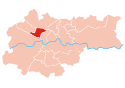
 Location of Krowodrza within Kraków | |
| Coordinates: 50°4′0″N 19°55′0″E / 50.06667°N 19.91667°E | |
| Country | |
| Voivodeship | Lesser Poland |
| County/City | Kraków |
| Government | |
| • President | Zygmunt Wierzbicki |
| Area | |
| • Total | 5.62 km2 (2.17 sq mi) |
| Population (2014) | |
| • Total | 31,870 |
| • Density | 5,700/km2 (15,000/sq mi) |
| Time zone | UTC+1 ( CET) |
| • Summer ( DST) | UTC+2 ( CEST) |
| Area code | +48 12 |
| Website | http://www.dzielnica5.krakow.pl |
Krowodrza is one of 18 districts of Kraków, located in the western part of the city. The name Krowodrza comes from a village of same name that is now a part of the district.
According to the Central Statistical Office data, the district's area is 5.62 square kilometres (2.17 square miles) and 31 870 people inhabit Krowodrza. [1]
Subdivisions of Krowodrza
Krowodrza is divided into smaller subdivisions ( osiedles). Here's a list of them.
- Cichy Kącik
- Czarna Wieś
- Krowodrza
- Łobzów
- Miasteczko Studenckie AGH
- Nowa Wieś
Population

References
- ^ "Information about Krowodrza district". Biuletyn Informacji Publicznej. Retrieved 30 August 2017.
External links
Krowodrza | |
|---|---|
 | |
 Location of Krowodrza within Kraków | |
| Coordinates: 50°4′0″N 19°55′0″E / 50.06667°N 19.91667°E | |
| Country | |
| Voivodeship | Lesser Poland |
| County/City | Kraków |
| Government | |
| • President | Zygmunt Wierzbicki |
| Area | |
| • Total | 5.62 km2 (2.17 sq mi) |
| Population (2014) | |
| • Total | 31,870 |
| • Density | 5,700/km2 (15,000/sq mi) |
| Time zone | UTC+1 ( CET) |
| • Summer ( DST) | UTC+2 ( CEST) |
| Area code | +48 12 |
| Website | http://www.dzielnica5.krakow.pl |
Krowodrza is one of 18 districts of Kraków, located in the western part of the city. The name Krowodrza comes from a village of same name that is now a part of the district.
According to the Central Statistical Office data, the district's area is 5.62 square kilometres (2.17 square miles) and 31 870 people inhabit Krowodrza. [1]
Subdivisions of Krowodrza
Krowodrza is divided into smaller subdivisions ( osiedles). Here's a list of them.
- Cichy Kącik
- Czarna Wieś
- Krowodrza
- Łobzów
- Miasteczko Studenckie AGH
- Nowa Wieś
Population

References
- ^ "Information about Krowodrza district". Biuletyn Informacji Publicznej. Retrieved 30 August 2017.