Photos • Location

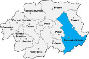
Rimavská Sobota District in the Banská Bystrica region

6: Banská Bystrica Region

Kráľ ( Hungarian: Sajószentkirály) is a village and municipality in the Rimavská Sobota District of the Banská Bystrica Region of southern Slovakia.

Genealogical resources
The records for genealogical research are available at the state archive "Statny Archiv in Banska Bystrica,
Slovakia"
- Lutheran church records (births/marriages/deaths): 1730-1895 (parish B)
- Reformated church records (births/marriages/deaths): 1778-1899 (parish B)
See also
External links
- https://web.archive.org/web/20080111223415/http://www.statistics.sk/mosmis/eng/run.html
- Surnames of living people in Kral
48°19′40″N 20°20′30″E / 48.32778°N 20.34167°E

Kráľ ( Hungarian: Sajószentkirály) is a village and municipality in the Rimavská Sobota District of the Banská Bystrica Region of southern Slovakia.

Genealogical resources
The records for genealogical research are available at the state archive "Statny Archiv in Banska Bystrica,
Slovakia"
- Lutheran church records (births/marriages/deaths): 1730-1895 (parish B)
- Reformated church records (births/marriages/deaths): 1778-1899 (parish B)
See also
External links
- https://web.archive.org/web/20080111223415/http://www.statistics.sk/mosmis/eng/run.html
- Surnames of living people in Kral
48°19′40″N 20°20′30″E / 48.32778°N 20.34167°E