Photos • Location

Hil
| |
|---|---|
Municipality | |
| Coordinates: 41°28′02″N 48°20′38″E / 41.46722°N 48.34389°E | |
| Country | |
| Rayon | Qusar |
| Population | |
| • Total | 5,022 |
| Time zone | UTC+4 ( AZT) |
| • Summer ( DST) | UTC+5 ( AZT) |
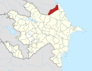
Hil (also, Gil’, Lezgian: Гьил) is a village and the most populous municipality, except for the capital Qusar, in the Qusar Rayon of Azerbaijan. It has a population of 5,022. The village is mostly inhabited by Lezgins.
References
Wikimedia Commons has media related to
Hil.
1970 ethnic composition of the Qusar Rayon(Russian): http://www.ethno-kavkaz.narod.ru/kusary70.html


