Photos • Location


Gyulagarak
Գյուլագարակ | |
|---|---|
 | |
 Coat of arms | |
 Gyulagarak | |
| Coordinates: 40°57′55.86″N 44°28′12.80″E / 40.9655167°N 44.4702222°E | |
| Country | |
| Province | Lori |
| Elevation | 1,360 m (4,460 ft) |
| Population | |
| • Total | 1,870 |
| Time zone | UTC+4 ( AMT) |
Gyulagarak ( Armenian: Գյուլագարակ) is a village in the Lori Province of Armenia. Stepanavan Dendropark is located near the village.
The village was formerly known as Gyulabarak.
-

-

-
 WWII Memorial
 -
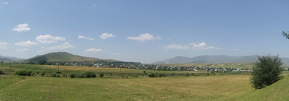 Panorama of Gyulagarak from near Hobardzi


.jpg)

- Hrant Shahinyan, two-time Olympic and World champion in gymnastics
Wikimedia Commons has media related to
Gyulagarak.

|
| This article about a location in Lori Province, Armenia is a stub. You can help Wikipedia by expanding it. |
Gyulagarak
Գյուլագարակ | |
|---|---|
|
| |
|
Coat of arms | |
Gyulagarak | |
| Coordinates: 40°57′55.86″N 44°28′12.80″E / 40.9655167°N 44.4702222°E | |
| Country | |
| Province | Lori |
| Elevation | 1,360 m (4,460 ft) |
| Population | |
| • Total | 1,870 |
| Time zone | UTC+4 ( AMT) |
Gyulagarak ( Armenian: Գյուլագարակ) is a village in the Lori Province of Armenia. Stepanavan Dendropark is located near the village.
The village was formerly known as Gyulabarak.
-
-
-
WWII Memorial
-
Panorama of Gyulagarak from near Hobardzi
- Hrant Shahinyan, two-time Olympic and World champion in gymnastics
Wikimedia Commons has media related to
Gyulagarak.
|
| This article about a location in Lori Province, Armenia is a stub. You can help Wikipedia by expanding it. |