Photos • Location

Location of the Ljubovija municipality in
Serbia
Gračanica
Грачаница (
Serbian) | |
|---|---|
 | |
| Coordinates: 44°14′36.8″N 19°23′21.94″E / 44.243556°N 19.3894278°E | |
| Country | |
| Municipality | Ljubovija |
| Time zone | UTC+1 ( CET) |
| • Summer ( DST) | UTC+2 ( CEST) |
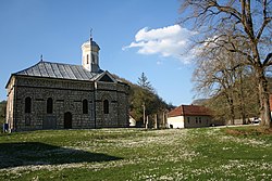
Gračanica ( Serbian Cyrillic: Грачаница) is a village in Serbia. It is situated in the Ljubovija municipality, in the Mačva District of Central Serbia. The population of the village in 2002 was 465, all of whom were ethnic Serbs.

Historical population
- 1948: 990
- 1953: 1,160
- 1961: 1,096
- 1971: 711
- 1981: 630
- 1991: 536
- 2002: 465 [1]
References
- ^ In Serbian Књига 9, Становништво, упоредни преглед броја становника 1948, 1953, 1961, 1971, 1981, 1991, 2002, подаци по насељима, Републички завод за статистику, Београд, мај 2004, ISBN 86-84433-14-9
See also
Gračanica
Грачаница (
Serbian) | |
|---|---|
 | |
| Coordinates: 44°14′36.8″N 19°23′21.94″E / 44.243556°N 19.3894278°E | |
| Country | |
| Municipality | Ljubovija |
| Time zone | UTC+1 ( CET) |
| • Summer ( DST) | UTC+2 ( CEST) |
Gračanica ( Serbian Cyrillic: Грачаница) is a village in Serbia. It is situated in the Ljubovija municipality, in the Mačva District of Central Serbia. The population of the village in 2002 was 465, all of whom were ethnic Serbs.

Historical population
- 1948: 990
- 1953: 1,160
- 1961: 1,096
- 1971: 711
- 1981: 630
- 1991: 536
- 2002: 465 [1]
References
- ^ In Serbian Књига 9, Становништво, упоредни преглед броја становника 1948, 1953, 1961, 1971, 1981, 1991, 2002, подаци по насељима, Републички завод за статистику, Београд, мај 2004, ISBN 86-84433-14-9
