
Original file (SVG file, nominally 959 × 593 pixels, file size: 26 KB)
| This is a file from the
Wikimedia Commons. Information from its
description page there is shown below. Commons is a freely licensed media file repository. You can help. |
Summary
| Description |
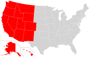
English: A map of the United States that highlights the Western states.
Note, this is derived from existing US map SVG as found at: File:Blank_US_Map_(states_only).svg and highlighting states based on low-res PNG found at: File:Map_of_USA_highlighting_West.png |
| Source | WikiMedia |
| Author | Self |
.svg)
Licensing

|
Permission is granted to copy, distribute and/or modify this document under the terms of the GNU Free Documentation License, Version 1.2 or any later version published by the Free Software Foundation; with no Invariant Sections, no Front-Cover Texts, and no Back-Cover Texts. A copy of the license is included in the section entitled GNU Free Documentation License. |
- You are free:
- to share – to copy, distribute and transmit the work
- to remix – to adapt the work
- Under the following conditions:
- attribution – You must give appropriate credit, provide a link to the license, and indicate if changes were made. You may do so in any reasonable manner, but not in any way that suggests the licensor endorses you or your use.
- share alike – If you remix, transform, or build upon the material, you must distribute your contributions under the same or compatible license as the original.
File history
Click on a date/time to view the file as it appeared at that time.
| Date/Time | Thumbnail | Dimensions | User | Comment | |
|---|---|---|---|---|---|
| current | 18:28, 15 November 2018 |
| 959 × 593 (26 KB) | Crazytonyi | {{Information |description ={{en|1=A map of the United States that highlights the Western states. Note, this is derived from existing US map SVG as found at: https://commons.wikimedia.org/wiki/File:Blank_US_Map_(states_only).svg and highlighting states based on low-res PNG found at: https://commons.wikimedia.org/wiki/File:Map_of_USA_highlighting_West.png}} |date = |source =WikiMedia |author =Self }} |
File usage
More than 100 pages use this file. The following list shows the first 100 pages that use this file only. A full list is available.
- Albuquerque New Mexico Temple
- Anchorage Alaska Temple
- Bengaluru India Temple
- Billings Montana Temple
- Boise Idaho Temple
- Bountiful Utah Temple
- Brigham City Utah Temple
- Cedar City Utah Temple
- Columbia River Washington Temple
- Comparison of temples of the Church of Jesus Christ of Latter-day Saints
- Denver Colorado Temple
- Deseret Peak Utah Temple
- Draper Utah Temple
- Feather River California Temple
- Fort Collins Colorado Temple
- Fresno California Temple
- Gila Valley Arizona Temple
- Gilbert Arizona Temple
- Helena Montana Temple
- History of the Jews in the American West
- Idaho Falls Idaho Temple
- Jordan River Utah Temple
- Kona Hawaii Temple
- Laie Hawaii Temple
- Las Vegas Nevada Temple
- Layton Utah Temple
- List of Stateside Puerto Rican communities
- List of temples of the Church of Jesus Christ of Latter-day Saints
- List of temples of the Church of Jesus Christ of Latter-day Saints by geographic region
- Logan Utah Temple
- Los Angeles California Temple
- Manti Utah Temple
- Medford Oregon Temple
- Meridian Idaho Temple
- Mesa Arizona Temple
- Monticello Utah Temple
- Moses Lake Washington Temple
- Mount Timpanogos Utah Temple
- Newport Beach California Temple
- Oakland California Temple
- Ogden Utah Temple
- Oquirrh Mountain Utah Temple
- Orem Utah Temple
- Payson Utah Temple
- Phoenix Arizona Temple
- Pocatello Idaho Temple
- Portland Oregon Temple
- Provo City Center Temple
- Provo Utah Temple
- Red Cliffs Utah Temple
- Redlands California Temple
- Reno Nevada Temple
- Rexburg Idaho Temple
- Sacramento California Temple
- Salt Lake Temple
- San Diego California Temple
- Saratoga Springs Utah Temple
- Seattle Washington Temple
- Snowflake Arizona Temple
- Spokane Washington Temple
- St. George Utah Temple
- Star Valley Wyoming Temple
- Syracuse Utah Temple
- Taylorsville Utah Temple
- Temple (LDS Church)
- Temple architecture (LDS Church)
- Tooele Technical College
- Tucson Arizona Temple
- Twin Falls Idaho Temple
- Vernal Utah Temple
- Western United States
- User:Arilicious
- User:Ashersea
- User:Cypella
- User:Dmm1169/sandbox/List
- User:Dmm1169/sandbox/Temples
- User:Douglas Lane
- User:Dronebogus
- User:EditMan13
- User:Ian9087
- User:Jeffholton
- User:Jmjosh90/sandbox/Los Angeles Temple
- User:Kaleeb18/UBX/Western USA
- User:Kaleeb18/userbox gallery
- User:MacDoesWiki
- User:Mainbasher
- User:Mosemamenti
- User:Mosemamenti/Usuario:Mosemamenti
- User:PolerBear5678
- User:Pyro3d
- User:Rallybrendan2006
- User:Tlonedyr
- User:Ultimate Roadgeek
- User:XanSurnamehere
- User:XanSurnamehere/sandbox
- Wikipedia:Userboxes/Location/United States
- Template:LDS-Temples-Geo
- Template:LDS-US-West
- Template:US-west-university-stub
- Template:User Western US
View more links to this file.
Global file usage
The following other wikis use this file:
- Usage on ar.wikipedia.org
- Usage on azb.wikipedia.org
- Usage on ca.wikipedia.org
- Usage on da.wikipedia.org
- Usage on de.wikipedia.org
- Usage on eo.wikipedia.org
- Usage on fa.wikipedia.org
- Usage on he.wikipedia.org
- Usage on hy.wikipedia.org
- Usage on ko.wikipedia.org
- Usage on pt.wikipedia.org
- Usage on ru.wikipedia.org
- Usage on simple.wikipedia.org
- Usage on vec.wikipedia.org
- Usage on www.wikidata.org
- Usage on zh.wikipedia.org
Metadata
Original file (SVG file, nominally 959 × 593 pixels, file size: 26 KB)
| This is a file from the
Wikimedia Commons. Information from its
description page there is shown below. Commons is a freely licensed media file repository. You can help. |
Summary
| Description |
English: A map of the United States that highlights the Western states.
Note, this is derived from existing US map SVG as found at: File:Blank_US_Map_(states_only).svg and highlighting states based on low-res PNG found at: File:Map_of_USA_highlighting_West.png |
| Source | WikiMedia |
| Author | Self |
Licensing
|
|
Permission is granted to copy, distribute and/or modify this document under the terms of the GNU Free Documentation License, Version 1.2 or any later version published by the Free Software Foundation; with no Invariant Sections, no Front-Cover Texts, and no Back-Cover Texts. A copy of the license is included in the section entitled GNU Free Documentation License. |
- You are free:
- to share – to copy, distribute and transmit the work
- to remix – to adapt the work
- Under the following conditions:
- attribution – You must give appropriate credit, provide a link to the license, and indicate if changes were made. You may do so in any reasonable manner, but not in any way that suggests the licensor endorses you or your use.
- share alike – If you remix, transform, or build upon the material, you must distribute your contributions under the same or compatible license as the original.
File history
Click on a date/time to view the file as it appeared at that time.
| Date/Time | Thumbnail | Dimensions | User | Comment | |
|---|---|---|---|---|---|
| current | 18:28, 15 November 2018 |
| 959 × 593 (26 KB) | Crazytonyi | {{Information |description ={{en|1=A map of the United States that highlights the Western states. Note, this is derived from existing US map SVG as found at: https://commons.wikimedia.org/wiki/File:Blank_US_Map_(states_only).svg and highlighting states based on low-res PNG found at: https://commons.wikimedia.org/wiki/File:Map_of_USA_highlighting_West.png}} |date = |source =WikiMedia |author =Self }} |
File usage
More than 100 pages use this file. The following list shows the first 100 pages that use this file only. A full list is available.
- Albuquerque New Mexico Temple
- Anchorage Alaska Temple
- Bengaluru India Temple
- Billings Montana Temple
- Boise Idaho Temple
- Bountiful Utah Temple
- Brigham City Utah Temple
- Cedar City Utah Temple
- Columbia River Washington Temple
- Comparison of temples of the Church of Jesus Christ of Latter-day Saints
- Denver Colorado Temple
- Deseret Peak Utah Temple
- Draper Utah Temple
- Feather River California Temple
- Fort Collins Colorado Temple
- Fresno California Temple
- Gila Valley Arizona Temple
- Gilbert Arizona Temple
- Helena Montana Temple
- History of the Jews in the American West
- Idaho Falls Idaho Temple
- Jordan River Utah Temple
- Kona Hawaii Temple
- Laie Hawaii Temple
- Las Vegas Nevada Temple
- Layton Utah Temple
- List of Stateside Puerto Rican communities
- List of temples of the Church of Jesus Christ of Latter-day Saints
- List of temples of the Church of Jesus Christ of Latter-day Saints by geographic region
- Logan Utah Temple
- Los Angeles California Temple
- Manti Utah Temple
- Medford Oregon Temple
- Meridian Idaho Temple
- Mesa Arizona Temple
- Monticello Utah Temple
- Moses Lake Washington Temple
- Mount Timpanogos Utah Temple
- Newport Beach California Temple
- Oakland California Temple
- Ogden Utah Temple
- Oquirrh Mountain Utah Temple
- Orem Utah Temple
- Payson Utah Temple
- Phoenix Arizona Temple
- Pocatello Idaho Temple
- Portland Oregon Temple
- Provo City Center Temple
- Provo Utah Temple
- Red Cliffs Utah Temple
- Redlands California Temple
- Reno Nevada Temple
- Rexburg Idaho Temple
- Sacramento California Temple
- Salt Lake Temple
- San Diego California Temple
- Saratoga Springs Utah Temple
- Seattle Washington Temple
- Snowflake Arizona Temple
- Spokane Washington Temple
- St. George Utah Temple
- Star Valley Wyoming Temple
- Syracuse Utah Temple
- Taylorsville Utah Temple
- Temple (LDS Church)
- Temple architecture (LDS Church)
- Tooele Technical College
- Tucson Arizona Temple
- Twin Falls Idaho Temple
- Vernal Utah Temple
- Western United States
- User:Arilicious
- User:Ashersea
- User:Cypella
- User:Dmm1169/sandbox/List
- User:Dmm1169/sandbox/Temples
- User:Douglas Lane
- User:Dronebogus
- User:EditMan13
- User:Ian9087
- User:Jeffholton
- User:Jmjosh90/sandbox/Los Angeles Temple
- User:Kaleeb18/UBX/Western USA
- User:Kaleeb18/userbox gallery
- User:MacDoesWiki
- User:Mainbasher
- User:Mosemamenti
- User:Mosemamenti/Usuario:Mosemamenti
- User:PolerBear5678
- User:Pyro3d
- User:Rallybrendan2006
- User:Tlonedyr
- User:Ultimate Roadgeek
- User:XanSurnamehere
- User:XanSurnamehere/sandbox
- Wikipedia:Userboxes/Location/United States
- Template:LDS-Temples-Geo
- Template:LDS-US-West
- Template:US-west-university-stub
- Template:User Western US
View more links to this file.
Global file usage
The following other wikis use this file:
- Usage on ar.wikipedia.org
- Usage on azb.wikipedia.org
- Usage on ca.wikipedia.org
- Usage on da.wikipedia.org
- Usage on de.wikipedia.org
- Usage on eo.wikipedia.org
- Usage on fa.wikipedia.org
- Usage on he.wikipedia.org
- Usage on hy.wikipedia.org
- Usage on ko.wikipedia.org
- Usage on pt.wikipedia.org
- Usage on ru.wikipedia.org
- Usage on simple.wikipedia.org
- Usage on vec.wikipedia.org
- Usage on www.wikidata.org
- Usage on zh.wikipedia.org