
Size of this preview:
713 × 599 pixels. Other resolutions:
286 × 240 pixels |
571 × 480 pixels |
914 × 768 pixels |
1,219 × 1,024 pixels |
2,437 × 2,048 pixels |
2,951 × 2,480 pixels.
Original file (2,951 × 2,480 pixels, file size: 3.55 MB, MIME type: image/png)
| This is a file from the
Wikimedia Commons. Information from its
description page there is shown below. Commons is a freely licensed media file repository. You can help. |
Summary
| Description |
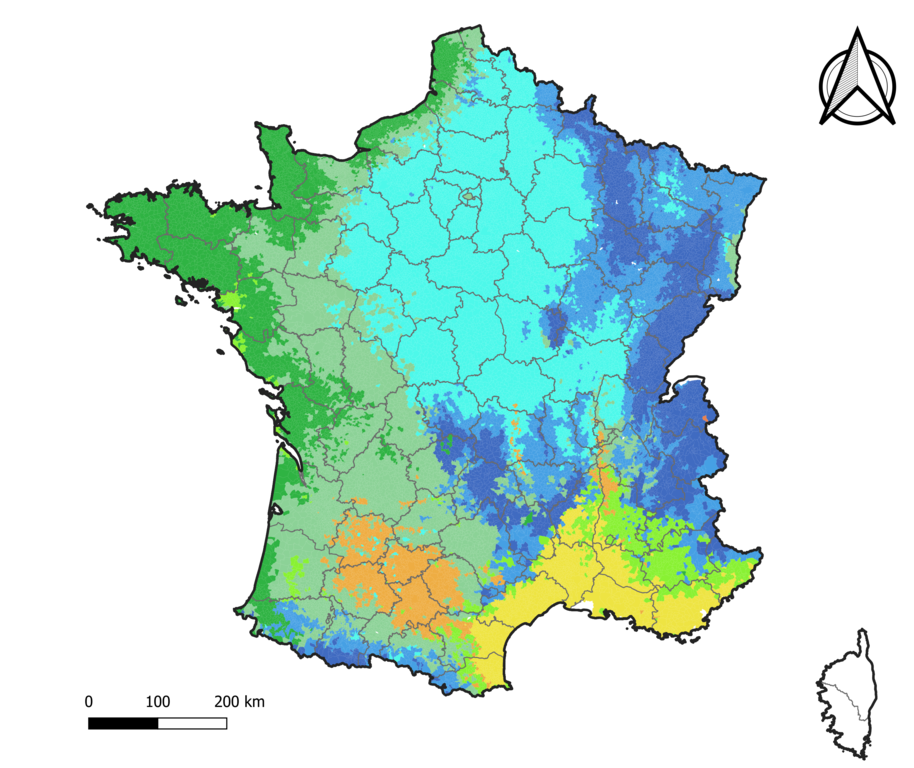
Français : Carte de la typologie climatique du territoire français en 8 classes. |
| Date | |
| Source | Own work |
| Author | Roland45 |
Sources des données :
- Découpage administratif communal et départemental : Export simple de janvier 2020 - vérifié et simplifié à 5 m sur le site du portail de données libres du gouvernement français, élaboré avec le concours des contributeurs à OpenStreetMap
- Typologie climatique : typologie climatique définie par une étude de 2010.
Assemblé et enrichi dans fr:QGis.
| Typologie des climats de 2010 | |
|---|---|
| Type 1 : les climats de montagne | |
| Type 2 : le climat semi-continental et le climat des marges montagnardes | |
| Type 3 : Le climat océanique dégradé des plaines du Centre et du Nord | |
| Type 4 : Le climat océanique altéré | |
| Type 5 : Le climat océanique franc | |
| Type 6 : Le climat méditerranéen altéré | |
| Type 7 : Le climat du Bassin du Sud-Ouest | |
| Type 8 : Le climat méditerranéen franc | |
Licensing
I, the copyright holder of this work, hereby publish it under the following license:
This file is licensed under the
Creative Commons
Attribution-Share Alike 4.0 International license.
- You are free:
- to share – to copy, distribute and transmit the work
- to remix – to adapt the work
- Under the following conditions:
- attribution – You must give appropriate credit, provide a link to the license, and indicate if changes were made. You may do so in any reasonable manner, but not in any way that suggests the licensor endorses you or your use.
- share alike – If you remix, transform, or build upon the material, you must distribute your contributions under the same or compatible license as the original.
File history
Click on a date/time to view the file as it appeared at that time.
| Date/Time | Thumbnail | Dimensions | User | Comment | |
|---|---|---|---|---|---|
| current | 07:59, 1 June 2021 |
| 2,951 × 2,480 (3.55 MB) | Roland45 | Correction pour la Corse (absence de données dans la base communale de 2010) |
| 14:31, 31 May 2021 |
 | 2,951 × 2,480 (3.6 MB) | Roland45 | == {{int:filedesc}} == {{Information |description={{fr|1=Carte de la typologie climatique du territoire français en 8 classes.}} |date=2021-05-31 |source={{own}} |author= Roland45 |permission= |other versions= }} Sources des données : * Découpage administratif communal et départemental : [https://www.data.gouv.fr/fr/datasets/decoupage-administratif-communal-francais-issu-d-openstreetmap/ Export simple de janvier 2020 - vérifié et simplifié à 5 m] sur le site du [https://www.... |
File usage
The following pages on the English Wikipedia use this file (pages on other projects are not listed):
Global file usage
The following other wikis use this file:
- Usage on fr.wikipedia.org
Size of this preview:
713 × 599 pixels. Other resolutions:
286 × 240 pixels |
571 × 480 pixels |
914 × 768 pixels |
1,219 × 1,024 pixels |
2,437 × 2,048 pixels |
2,951 × 2,480 pixels.
Original file (2,951 × 2,480 pixels, file size: 3.55 MB, MIME type: image/png)
| This is a file from the
Wikimedia Commons. Information from its
description page there is shown below. Commons is a freely licensed media file repository. You can help. |
Summary
| Description |
Français : Carte de la typologie climatique du territoire français en 8 classes. |
| Date | |
| Source | Own work |
| Author | Roland45 |
Sources des données :
- Découpage administratif communal et départemental : Export simple de janvier 2020 - vérifié et simplifié à 5 m sur le site du portail de données libres du gouvernement français, élaboré avec le concours des contributeurs à OpenStreetMap
- Typologie climatique : typologie climatique définie par une étude de 2010.
Assemblé et enrichi dans fr:QGis.
| Typologie des climats de 2010 | |
|---|---|
| Type 1 : les climats de montagne | |
| Type 2 : le climat semi-continental et le climat des marges montagnardes | |
| Type 3 : Le climat océanique dégradé des plaines du Centre et du Nord | |
| Type 4 : Le climat océanique altéré | |
| Type 5 : Le climat océanique franc | |
| Type 6 : Le climat méditerranéen altéré | |
| Type 7 : Le climat du Bassin du Sud-Ouest | |
| Type 8 : Le climat méditerranéen franc | |
Licensing
I, the copyright holder of this work, hereby publish it under the following license:
This file is licensed under the
Creative Commons
Attribution-Share Alike 4.0 International license.
- You are free:
- to share – to copy, distribute and transmit the work
- to remix – to adapt the work
- Under the following conditions:
- attribution – You must give appropriate credit, provide a link to the license, and indicate if changes were made. You may do so in any reasonable manner, but not in any way that suggests the licensor endorses you or your use.
- share alike – If you remix, transform, or build upon the material, you must distribute your contributions under the same or compatible license as the original.
File history
Click on a date/time to view the file as it appeared at that time.
| Date/Time | Thumbnail | Dimensions | User | Comment | |
|---|---|---|---|---|---|
| current | 07:59, 1 June 2021 |
| 2,951 × 2,480 (3.55 MB) | Roland45 | Correction pour la Corse (absence de données dans la base communale de 2010) |
| 14:31, 31 May 2021 |
| 2,951 × 2,480 (3.6 MB) | Roland45 | == {{int:filedesc}} == {{Information |description={{fr|1=Carte de la typologie climatique du territoire français en 8 classes.}} |date=2021-05-31 |source={{own}} |author= Roland45 |permission= |other versions= }} Sources des données : * Découpage administratif communal et départemental : [https://www.data.gouv.fr/fr/datasets/decoupage-administratif-communal-francais-issu-d-openstreetmap/ Export simple de janvier 2020 - vérifié et simplifié à 5 m] sur le site du [https://www.... |
File usage
The following pages on the English Wikipedia use this file (pages on other projects are not listed):
Global file usage
The following other wikis use this file:
- Usage on fr.wikipedia.org