
Original file (SVG file, nominally 2,754 × 1,398 pixels, file size: 1.05 MB)
| This is a file from the
Wikimedia Commons. Information from its
description page there is shown below. Commons is a freely licensed media file repository. You can help. |
Summary
| Description |
English:
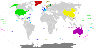
Dependent territories and their sovereign countries. All territories are labelled according to ISO 3166-1. Each territory in the United States Minor Outlying Islands is labelled UM- followed by the first letter of its name and another unique letter if needed. The following territories do not have ISO 3166-1 codes: 1: Akrotiri and Dhekelia 2: Ashmore and Cartier Islands 3: Coral Sea Islands Español: Los Territorios dependientes en el Mundo y los países soberanos de los que dependen.
Todos los territorios están etiquetados según la norma ISO 3166-1. Los siguientes territorios no tienen códigos ISO 3166-1: 1) Akrotiri y Dhekelia; 2) Islas Ashmore y Cartier; 3) Islas del Mar de CoralFrançais : Les territoires dépendants dans le monde et les pays souverains dont ils dépendent.
Tous les territoires sont labellisés selon la norme ISO 3166-1. Les territoires suivants n'ont pas de codes ISO 3166-1 : 1) Akrotiri et Dhekelia ; 2) Iles Ashmore et Cartier ; 3) Iles de la mer de CorailPortuguês: Os territórios dependentes no mundo e os países soberanos dos quais eles dependem.
Todos os territórios são rotulados de acordo com a norma ISO 3166-1. Os seguintes territórios não possuem códigos ISO 3166-1: 1) Akrotiri e Dhekelia; 2) Ashmore e Ilhas Cartier; 3) Ilhas do Mar de CorallDeutsch: Die abhängigen Gebiete in der Welt und die souveränen Länder, von denen sie abhängen.
Alle Gebiete sind gemäß ISO 3166-1 gekennzeichnet. Die folgenden Gebiete haben keine ISO 3166-1-Codes: 1) Akrotiri und Dhekelia; 2) Ashmore- und Cartier-Inseln; 3) Korallenmeerinseln |
| Date | |
| Source | Own work, based on BlankMap-World.svg |
| Author | Heitordp |
Licensing
| This file is made available under the Creative Commons CC0 1.0 Universal Public Domain Dedication. | |
| The person who associated a work with this deed has dedicated the work to the
public domain by waiving all of their rights to the work worldwide under copyright law, including all related and neighboring rights, to the extent allowed by law. You can copy, modify, distribute and perform the work, even for commercial purposes, all without asking permission.
|
File history
Click on a date/time to view the file as it appeared at that time.
| Date/Time | Thumbnail | Dimensions | User | Comment | |
|---|---|---|---|---|---|
| current | 22:56, 20 July 2020 |
| 2,754 × 1,398 (1.05 MB) | M.Bitton | Added the missing border between Morocco and Western Sahara. |
| 20:58, 12 July 2020 |
 | 2,754 × 1,398 (1.05 MB) | Heitordp | Corrected code of Heard Island and McDonald Islands, and removed color from Taiwan | |
| 12:13, 12 July 2020 |
 | 2,754 × 1,398 (1.08 MB) | Wiz9999 | Replacing XAD, XAC, and XCS with 1,2, and 3 to make the map more neutral. XAD, XAC, and XCS do not represent any formal labelling/classification system to describe Akrotiri and Dhekelia, Ashmore and Cartier Islands, and Coral Sea Islands outside of this file. | |
| 22:05, 7 July 2020 |
 | 2,754 × 1,398 (1.05 MB) | Heitordp | Uploaded own work with UploadWizard |
File usage
Global file usage
The following other wikis use this file:
- Usage on bn.wikipedia.org
- Usage on eu.wikipedia.org
- Usage on mk.wikipedia.org
- Usage on pt.wikipedia.org
- Usage on tr.wikipedia.org
Metadata
Original file (SVG file, nominally 2,754 × 1,398 pixels, file size: 1.05 MB)
| This is a file from the
Wikimedia Commons. Information from its
description page there is shown below. Commons is a freely licensed media file repository. You can help. |
Summary
| Description |
English:
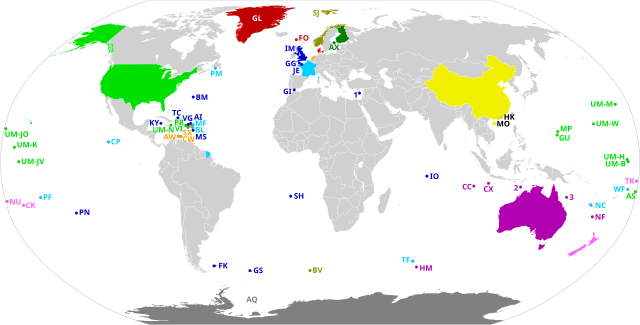
Dependent territories and their sovereign countries. All territories are labelled according to ISO 3166-1. Each territory in the United States Minor Outlying Islands is labelled UM- followed by the first letter of its name and another unique letter if needed. The following territories do not have ISO 3166-1 codes: 1: Akrotiri and Dhekelia 2: Ashmore and Cartier Islands 3: Coral Sea Islands Español: Los Territorios dependientes en el Mundo y los países soberanos de los que dependen.
Todos los territorios están etiquetados según la norma ISO 3166-1. Los siguientes territorios no tienen códigos ISO 3166-1: 1) Akrotiri y Dhekelia; 2) Islas Ashmore y Cartier; 3) Islas del Mar de CoralFrançais : Les territoires dépendants dans le monde et les pays souverains dont ils dépendent.
Tous les territoires sont labellisés selon la norme ISO 3166-1. Les territoires suivants n'ont pas de codes ISO 3166-1 : 1) Akrotiri et Dhekelia ; 2) Iles Ashmore et Cartier ; 3) Iles de la mer de CorailPortuguês: Os territórios dependentes no mundo e os países soberanos dos quais eles dependem.
Todos os territórios são rotulados de acordo com a norma ISO 3166-1. Os seguintes territórios não possuem códigos ISO 3166-1: 1) Akrotiri e Dhekelia; 2) Ashmore e Ilhas Cartier; 3) Ilhas do Mar de CorallDeutsch: Die abhängigen Gebiete in der Welt und die souveränen Länder, von denen sie abhängen.
Alle Gebiete sind gemäß ISO 3166-1 gekennzeichnet. Die folgenden Gebiete haben keine ISO 3166-1-Codes: 1) Akrotiri und Dhekelia; 2) Ashmore- und Cartier-Inseln; 3) Korallenmeerinseln |
| Date | |
| Source | Own work, based on BlankMap-World.svg |
| Author | Heitordp |
Licensing
| This file is made available under the Creative Commons CC0 1.0 Universal Public Domain Dedication. | |
| The person who associated a work with this deed has dedicated the work to the
public domain by waiving all of their rights to the work worldwide under copyright law, including all related and neighboring rights, to the extent allowed by law. You can copy, modify, distribute and perform the work, even for commercial purposes, all without asking permission.
|
File history
Click on a date/time to view the file as it appeared at that time.
| Date/Time | Thumbnail | Dimensions | User | Comment | |
|---|---|---|---|---|---|
| current | 22:56, 20 July 2020 |
| 2,754 × 1,398 (1.05 MB) | M.Bitton | Added the missing border between Morocco and Western Sahara. |
| 20:58, 12 July 2020 |
| 2,754 × 1,398 (1.05 MB) | Heitordp | Corrected code of Heard Island and McDonald Islands, and removed color from Taiwan | |
| 12:13, 12 July 2020 |
| 2,754 × 1,398 (1.08 MB) | Wiz9999 | Replacing XAD, XAC, and XCS with 1,2, and 3 to make the map more neutral. XAD, XAC, and XCS do not represent any formal labelling/classification system to describe Akrotiri and Dhekelia, Ashmore and Cartier Islands, and Coral Sea Islands outside of this file. | |
| 22:05, 7 July 2020 |
| 2,754 × 1,398 (1.05 MB) | Heitordp | Uploaded own work with UploadWizard |
File usage
Global file usage
The following other wikis use this file:
- Usage on bn.wikipedia.org
- Usage on eu.wikipedia.org
- Usage on mk.wikipedia.org
- Usage on pt.wikipedia.org
- Usage on tr.wikipedia.org