Danubemap.png (747 × 480 pixels, file size: 601 KB, MIME type: image/png)
| This is a file from the
Wikimedia Commons. Information from its
description page there is shown below. Commons is a freely licensed media file repository. You can help. |

|
This map image could be re-created using
vector graphics as an
SVG file. This has several advantages; see
Commons:Media for cleanup for more information. If an SVG form of this image is available, please upload it and afterwards replace this template with
{{
vector version available|new image name}}
.
It is recommended to name the SVG file “Danubemap.svg”—then the template Vector version available (or Vva) does not need the new image name parameter. |
Summary
Licensing
This image is in the
public domain because it contains materials that originally came from the United States
Central Intelligence Agency's
World Factbook.
|
 |
File history
Click on a date/time to view the file as it appeared at that time.
| Date/Time | Thumbnail | Dimensions | User | Comment | |
|---|---|---|---|---|---|
| current | 05:34, 12 February 2007 |
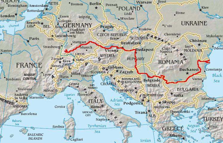
| 747 × 480 (601 KB) | Geologik | Map showing the flow of the Danube River. Uses the map of Europe from the CIA World Factbook. |
File usage
More than 100 pages use this file. The following list shows the first 100 pages that use this file only. A full list is available.
- Ada Kaleh
- Argeș (river)
- Baja, Hungary
- Balta Ialomiței
- Battle of Nicopolis
- Bačka Palanka
- Belene Island
- Belgrade
- Bratislava
- Breg (river)
- Brigach
- Brăila
- Budapest
- Calafat
- Cerna (Danube)
- Cernavodă
- Corabia
- Csepel Island
- Danube
- Danube–Black Sea Canal
- Danubian corridor
- Donaueschingen
- Donauinsel
- Dranova Island
- Drava
- Drobeta-Turnu Severin
- Esztergom
- Galați
- Geography of Austria
- Geography of Bulgaria
- Geography of Croatia
- Geography of Germany
- Geography of Hungary
- Geography of Moldova
- Geography of Romania
- Geography of Serbia
- Geography of Slovakia
- Geography of Ukraine
- Great Brăila Island
- Great Morava
- Great War Island
- Győr
- Hron
- Hungarian Parliament Building
- Ialomița (river)
- Iller
- Ilok
- Ingolstadt
- Inn (river)
- Internationalization of the Danube River
- Ipeľ
- Iskar (river)
- Island of Vukovar
- Island of Šarengrad
- Izmail
- Jiu (river)
- Karaš
- Kiliia
- Kozloduy Island
- Krems an der Donau
- Lech (river)
- Linz
- List of crossings of the Danube
- List of islands in the Danube
- List of tributaries of the Danube
- Lom, Bulgaria
- Margaret Island
- Morava (river)
- Nera (Danube)
- Novi Sad
- Olt (river)
- Osam
- Ostrovo (island)
- Ostrovul Ciocănești
- Ostrovul Mare, Islaz
- Passau
- Regen (river)
- Regensburg
- Reni, Ukraine
- Rhine–Main–Danube Canal
- Ruse, Bulgaria
- Sava
- Shoes on the Danube Bank
- Siret (river)
- Smederevo
- Sulina
- Széchenyi Chain Bridge
- The Horse, the Wheel, and Language
- Timiș
- Tisza
- Tulcea
- Ulm
- Vardim Island
- Vedea
- Vidin
- Vienna
- Vit (river)
- Vukovar
- Váh
- Yantra (river)
View more links to this file.
Global file usage
The following other wikis use this file:
- Usage on ang.wikipedia.org
- Usage on ast.wikipedia.org
- Usage on av.wikipedia.org
- Usage on azb.wikipedia.org
- Usage on ban.wikipedia.org
- Usage on be-tarask.wikipedia.org
- Usage on bg.wikipedia.org
View more global usage of this file.
Metadata
Danubemap.png (747 × 480 pixels, file size: 601 KB, MIME type: image/png)
| This is a file from the
Wikimedia Commons. Information from its
description page there is shown below. Commons is a freely licensed media file repository. You can help. |
|
|
This map image could be re-created using
vector graphics as an
SVG file. This has several advantages; see
Commons:Media for cleanup for more information. If an SVG form of this image is available, please upload it and afterwards replace this template with
{{
vector version available|new image name}}
.
It is recommended to name the SVG file “Danubemap.svg”—then the template Vector version available (or Vva) does not need the new image name parameter. |
Summary
Licensing
This image is in the
public domain because it contains materials that originally came from the United States
Central Intelligence Agency's
World Factbook.
|
|
File history
Click on a date/time to view the file as it appeared at that time.
| Date/Time | Thumbnail | Dimensions | User | Comment | |
|---|---|---|---|---|---|
| current | 05:34, 12 February 2007 |
| 747 × 480 (601 KB) | Geologik | Map showing the flow of the Danube River. Uses the map of Europe from the CIA World Factbook. |
File usage
More than 100 pages use this file. The following list shows the first 100 pages that use this file only. A full list is available.
- Ada Kaleh
- Argeș (river)
- Baja, Hungary
- Balta Ialomiței
- Battle of Nicopolis
- Bačka Palanka
- Belene Island
- Belgrade
- Bratislava
- Breg (river)
- Brigach
- Brăila
- Budapest
- Calafat
- Cerna (Danube)
- Cernavodă
- Corabia
- Csepel Island
- Danube
- Danube–Black Sea Canal
- Danubian corridor
- Donaueschingen
- Donauinsel
- Dranova Island
- Drava
- Drobeta-Turnu Severin
- Esztergom
- Galați
- Geography of Austria
- Geography of Bulgaria
- Geography of Croatia
- Geography of Germany
- Geography of Hungary
- Geography of Moldova
- Geography of Romania
- Geography of Serbia
- Geography of Slovakia
- Geography of Ukraine
- Great Brăila Island
- Great Morava
- Great War Island
- Győr
- Hron
- Hungarian Parliament Building
- Ialomița (river)
- Iller
- Ilok
- Ingolstadt
- Inn (river)
- Internationalization of the Danube River
- Ipeľ
- Iskar (river)
- Island of Vukovar
- Island of Šarengrad
- Izmail
- Jiu (river)
- Karaš
- Kiliia
- Kozloduy Island
- Krems an der Donau
- Lech (river)
- Linz
- List of crossings of the Danube
- List of islands in the Danube
- List of tributaries of the Danube
- Lom, Bulgaria
- Margaret Island
- Morava (river)
- Nera (Danube)
- Novi Sad
- Olt (river)
- Osam
- Ostrovo (island)
- Ostrovul Ciocănești
- Ostrovul Mare, Islaz
- Passau
- Regen (river)
- Regensburg
- Reni, Ukraine
- Rhine–Main–Danube Canal
- Ruse, Bulgaria
- Sava
- Shoes on the Danube Bank
- Siret (river)
- Smederevo
- Sulina
- Széchenyi Chain Bridge
- The Horse, the Wheel, and Language
- Timiș
- Tisza
- Tulcea
- Ulm
- Vardim Island
- Vedea
- Vidin
- Vienna
- Vit (river)
- Vukovar
- Váh
- Yantra (river)
View more links to this file.
Global file usage
The following other wikis use this file:
- Usage on ang.wikipedia.org
- Usage on ast.wikipedia.org
- Usage on av.wikipedia.org
- Usage on azb.wikipedia.org
- Usage on ban.wikipedia.org
- Usage on be-tarask.wikipedia.org
- Usage on bg.wikipedia.org
View more global usage of this file.