Balta Ialomiței is an island on the Danube, located in Ialomița County and Călărași County, Romania. It is surrounded by two branches of the Danube, named "Borcea" and "Dunărea Veche". Originally, a wetland, the island was covered with marshes, woods, lakes, and ponds, but some of the land was reclaimed for agriculture. Occasionally, some of these regions are still flooded. The A2 freeway passes through this island. The island has an area of 831.3 km2 (321.0 sq mi), with a length of 94 km (58 mi) and a width of 5 to 12.5 kilometres (3.1 to 7.8 mi). The average height is 10 to 17 metres (33 to 56 ft).
Gallery
-
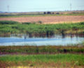 A pond in Balta Ialomiței
 -
 Balta Ialomiței, being flooded in April/May 2006
 -
 An agricultural field being flooded


References
44°30′10″N 27°59′43″E / 44.502872°N 27.995224°E
| Countries |  | |
|---|---|---|
| Cities | ||
| Tributaries | ||
| Canals | ||
| See also | ||
Balta Ialomiței is an island on the Danube, located in Ialomița County and Călărași County, Romania. It is surrounded by two branches of the Danube, named "Borcea" and "Dunărea Veche". Originally, a wetland, the island was covered with marshes, woods, lakes, and ponds, but some of the land was reclaimed for agriculture. Occasionally, some of these regions are still flooded. The A2 freeway passes through this island. The island has an area of 831.3 km2 (321.0 sq mi), with a length of 94 km (58 mi) and a width of 5 to 12.5 kilometres (3.1 to 7.8 mi). The average height is 10 to 17 metres (33 to 56 ft).
Gallery
-
A pond in Balta Ialomiței
-
Balta Ialomiței, being flooded in April/May 2006
-
An agricultural field being flooded
References
44°30′10″N 27°59′43″E / 44.502872°N 27.995224°E
| Countries | | |
|---|---|---|
| Cities | ||
| Tributaries | ||
| Canals | ||
| See also | ||