Photos • Location


Size of this JPG preview of this TIF file:
750 × 599 pixels. Other resolutions:
300 × 240 pixels |
601 × 480 pixels |
961 × 768 pixels |
1,280 × 1,023 pixels |
2,560 × 2,046 pixels |
4,632 × 3,702 pixels.
Original file (4,632 × 3,702 pixels, file size: 16.36 MB, MIME type: image/tiff)
| This is a file from the
Wikimedia Commons. Information from its
description page there is shown below. Commons is a freely licensed media file repository. You can help. |
Summary
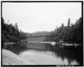
| CONTEXTUAL VIEW OF BRIDGE IN SETTING, LOOKING NORTHEAST, FROM UPSTREAM - Smith River Bridge, CA State Highway 199 Spanning Smith River, Crescent City, Del Norte County, CA | ||||
|---|---|---|---|---|
| Photographer |
Tateishi, Don Related names:
|
|||
| Title |
CONTEXTUAL VIEW OF BRIDGE IN SETTING, LOOKING NORTHEAST, FROM UPSTREAM - Smith River Bridge, CA State Highway 199 Spanning Smith River, Crescent City, Del Norte County, CA |
|||
| Depicted place | California; Del Norte County; Crescent City | |||
| Date | 1989 | |||
| Dimensions | 4 x 5 in. | |||
| Current location |
Library of Congress Prints and Photographs Division Washington, D.C. 20540 USA
http://hdl.loc.gov/loc.pnp/pp.print |
|||
| Accession number |
HAER CAL,8-CRECI.V,1-2 |
|||
| Credit line |
|
|||
| Notes |
|
|||
| Source | https://www.loc.gov/pictures/item/ca1545.photos.020447p | |||
| Permission ( Reusing this file) |
|
|||

| Object location |
| View this and other nearby images on: OpenStreetMap |
|
|---|
File history
Click on a date/time to view the file as it appeared at that time.
| Date/Time | Thumbnail | Dimensions | User | Comment | |
|---|---|---|---|---|---|
| current | 19:15, 3 July 2014 |
 | 4,632 × 3,702 (16.36 MB) | Fæ | GWToolset: Creating mediafile for Fæ. HABS batch upload 2 July 2014 (301:400) |
File usage
The following pages on the English Wikipedia use this file (pages on other projects are not listed):
Global file usage
The following other wikis use this file:
- Usage on he.wikipedia.org
Metadata
Size of this JPG preview of this TIF file:
750 × 599 pixels. Other resolutions:
300 × 240 pixels |
601 × 480 pixels |
961 × 768 pixels |
1,280 × 1,023 pixels |
2,560 × 2,046 pixels |
4,632 × 3,702 pixels.
Original file (4,632 × 3,702 pixels, file size: 16.36 MB, MIME type: image/tiff)
| This is a file from the
Wikimedia Commons. Information from its
description page there is shown below. Commons is a freely licensed media file repository. You can help. |
Summary
| CONTEXTUAL VIEW OF BRIDGE IN SETTING, LOOKING NORTHEAST, FROM UPSTREAM - Smith River Bridge, CA State Highway 199 Spanning Smith River, Crescent City, Del Norte County, CA | ||||
|---|---|---|---|---|
| Photographer |
Tateishi, Don Related names:
|
|||
| Title |
CONTEXTUAL VIEW OF BRIDGE IN SETTING, LOOKING NORTHEAST, FROM UPSTREAM - Smith River Bridge, CA State Highway 199 Spanning Smith River, Crescent City, Del Norte County, CA |
|||
| Depicted place | California; Del Norte County; Crescent City | |||
| Date | 1989 | |||
| Dimensions | 4 x 5 in. | |||
| Current location |
Library of Congress Prints and Photographs Division Washington, D.C. 20540 USA
http://hdl.loc.gov/loc.pnp/pp.print |
|||
| Accession number |
HAER CAL,8-CRECI.V,1-2 |
|||
| Credit line |
|
|||
| Notes |
|
|||
| Source | https://www.loc.gov/pictures/item/ca1545.photos.020447p | |||
| Permission ( Reusing this file) |
|
|||
| Object location |
| View this and other nearby images on: OpenStreetMap |
|
|---|
File history
Click on a date/time to view the file as it appeared at that time.
| Date/Time | Thumbnail | Dimensions | User | Comment | |
|---|---|---|---|---|---|
| current | 19:15, 3 July 2014 |
| 4,632 × 3,702 (16.36 MB) | Fæ | GWToolset: Creating mediafile for Fæ. HABS batch upload 2 July 2014 (301:400) |
File usage
The following pages on the English Wikipedia use this file (pages on other projects are not listed):
Global file usage
The following other wikis use this file:
- Usage on he.wikipedia.org