Size of this preview:
538 × 600 pixels. Other resolutions:
215 × 240 pixels |
600 × 669 pixels.
Original file (600 × 669 pixels, file size: 42 KB, MIME type: image/jpeg)
| This is a file from the
Wikimedia Commons. Information from its
description page there is shown below. Commons is a freely licensed media file repository. You can help. |

|
This ethnographic map image could be re-created using
vector graphics as an
SVG file. This has several advantages; see
Commons:Media for cleanup for more information. If an SVG form of this image is available, please upload it and afterwards replace this template with
{{
vector version available|new image name}}
.
It is recommended to name the SVG file “Azawad in context.svg”—then the template Vector version available (or Vva) does not need the new image name parameter. |


Summary
| Description |
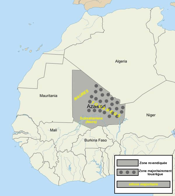
English: Area claimed by the National Movement for the Liberation of Azawad (MNLA). |
| Date | |
| Source | Own work |
| Author | BabyFoot |
This erea it's not majority Touareg.
Licensing
I, the copyright holder of this work, hereby publish it under the following license:
This file is licensed under the
Creative Commons
Attribution-Share Alike 3.0 Unported license.
- You are free:
- to share – to copy, distribute and transmit the work
- to remix – to adapt the work
- Under the following conditions:
- attribution – You must give appropriate credit, provide a link to the license, and indicate if changes were made. You may do so in any reasonable manner, but not in any way that suggests the licensor endorses you or your use.
- share alike – If you remix, transform, or build upon the material, you must distribute your contributions under the same or compatible license as the original.
File history
Click on a date/time to view the file as it appeared at that time.
| Date/Time | Thumbnail | Dimensions | User | Comment | |
|---|---|---|---|---|---|
| current | 17:46, 3 April 2012 |
| 600 × 669 (42 KB) | Saibo | Revert. please do not upload new file versions of maps which have the only purpose to "correct" a political border which is disputed. You can upload your version under a new name |
| 14:59, 2 April 2012 |
 | 600 × 669 (39 KB) | Karakizi | ameliorations | |
| 20:43, 23 March 2012 |
 | 600 × 669 (42 KB) | Monsieur Fou | some precision | |
| 22:54, 3 February 2012 |
 | 600 × 669 (45 KB) | BabyFoot |
File usage
The following pages on the English Wikipedia use this file (pages on other projects are not listed):
Global file usage
The following other wikis use this file:
- Usage on als.wikipedia.org
- Usage on azb.wikipedia.org
- Usage on ba.wikipedia.org
- Usage on be.wikipedia.org
- Usage on bs.wikipedia.org
- Usage on ca.wikipedia.org
- Usage on cy.wikipedia.org
- Usage on eo.wikipedia.org
- Usage on es.wikipedia.org
- Usage on et.wikipedia.org
- Usage on fr.wikipedia.org
- Usage on fr.wikinews.org
- Usage on hr.wikipedia.org
- Usage on it.wikipedia.org
- Usage on ja.wikipedia.org
- Usage on ko.wikipedia.org
- Usage on ms.wikipedia.org
- Usage on pl.wikipedia.org
- Usage on pt.wikipedia.org
- Usage on ru.wikipedia.org
- Usage on ru.wikinews.org
- Usage on sh.wikipedia.org
- Usage on sl.wikipedia.org
- Usage on sr.wikinews.org
- Usage on su.wikipedia.org
- Usage on ta.wikipedia.org
- Usage on ta.wikinews.org
- மாலியின் துவாரெக் போராளிகளின் இராணுவ நடவடிக்கை நிறுத்தம்
- துவாரெக் போராளிகள் மாலியின் வடக்கில் விடுதலைப் பிரகடனம்
- வார்ப்புரு:அசவாத்
- மாலியின் துவாரெக், இசுலாமியப் போராளிகள் இணைந்து அசவாத் பகுதியை இசுலாமிய நாடாக அறிவிப்பு
- மாலியின் வடக்கு நகர் ஒன்றை படையினர் போராளிகளிடம் இருந்து கைப்பற்றினர்
- மாலி சர்ச்சை: பிரெஞ்சுப் படையினர் போராளிகள் வசமுள்ள கிடால் நகரினுள் நுழைந்தனர்
- மாலியில் துவாரெக் போராளிகளின் சோதனைச் சாவடி மீது தாக்குதல், ஏழு பேர் உயிரிழப்பு
- வடக்கு மாலி தாக்குதலில் பிரெஞ்சுப் படைவீரர் உயிரிழப்பு
- துவாரெக் போராளிக் குழுவுடன் மாலி அரசு அமைதி உடன்பாடு
- மாலியில் துவாரெக் போராளிகள் போர் நிறுத்தத்தை முடித்துக் கொண்டனர்
- Usage on uk.wikipedia.org
- Usage on www.wikidata.org
- Usage on zh.wikipedia.org
View more global usage of this file.
Size of this preview:
538 × 600 pixels. Other resolutions:
215 × 240 pixels |
600 × 669 pixels.
Original file (600 × 669 pixels, file size: 42 KB, MIME type: image/jpeg)
| This is a file from the
Wikimedia Commons. Information from its
description page there is shown below. Commons is a freely licensed media file repository. You can help. |
|
|
This ethnographic map image could be re-created using
vector graphics as an
SVG file. This has several advantages; see
Commons:Media for cleanup for more information. If an SVG form of this image is available, please upload it and afterwards replace this template with
{{
vector version available|new image name}}
.
It is recommended to name the SVG file “Azawad in context.svg”—then the template Vector version available (or Vva) does not need the new image name parameter. |
Summary
| Description |
English: Area claimed by the National Movement for the Liberation of Azawad (MNLA). |
| Date | |
| Source | Own work |
| Author | BabyFoot |
This erea it's not majority Touareg.
Licensing
I, the copyright holder of this work, hereby publish it under the following license:
This file is licensed under the
Creative Commons
Attribution-Share Alike 3.0 Unported license.
- You are free:
- to share – to copy, distribute and transmit the work
- to remix – to adapt the work
- Under the following conditions:
- attribution – You must give appropriate credit, provide a link to the license, and indicate if changes were made. You may do so in any reasonable manner, but not in any way that suggests the licensor endorses you or your use.
- share alike – If you remix, transform, or build upon the material, you must distribute your contributions under the same or compatible license as the original.
File history
Click on a date/time to view the file as it appeared at that time.
| Date/Time | Thumbnail | Dimensions | User | Comment | |
|---|---|---|---|---|---|
| current | 17:46, 3 April 2012 |
| 600 × 669 (42 KB) | Saibo | Revert. please do not upload new file versions of maps which have the only purpose to "correct" a political border which is disputed. You can upload your version under a new name |
| 14:59, 2 April 2012 |
| 600 × 669 (39 KB) | Karakizi | ameliorations | |
| 20:43, 23 March 2012 |
| 600 × 669 (42 KB) | Monsieur Fou | some precision | |
| 22:54, 3 February 2012 |
| 600 × 669 (45 KB) | BabyFoot |
File usage
The following pages on the English Wikipedia use this file (pages on other projects are not listed):
Global file usage
The following other wikis use this file:
- Usage on als.wikipedia.org
- Usage on azb.wikipedia.org
- Usage on ba.wikipedia.org
- Usage on be.wikipedia.org
- Usage on bs.wikipedia.org
- Usage on ca.wikipedia.org
- Usage on cy.wikipedia.org
- Usage on eo.wikipedia.org
- Usage on es.wikipedia.org
- Usage on et.wikipedia.org
- Usage on fr.wikipedia.org
- Usage on fr.wikinews.org
- Usage on hr.wikipedia.org
- Usage on it.wikipedia.org
- Usage on ja.wikipedia.org
- Usage on ko.wikipedia.org
- Usage on ms.wikipedia.org
- Usage on pl.wikipedia.org
- Usage on pt.wikipedia.org
- Usage on ru.wikipedia.org
- Usage on ru.wikinews.org
- Usage on sh.wikipedia.org
- Usage on sl.wikipedia.org
- Usage on sr.wikinews.org
- Usage on su.wikipedia.org
- Usage on ta.wikipedia.org
- Usage on ta.wikinews.org
- மாலியின் துவாரெக் போராளிகளின் இராணுவ நடவடிக்கை நிறுத்தம்
- துவாரெக் போராளிகள் மாலியின் வடக்கில் விடுதலைப் பிரகடனம்
- வார்ப்புரு:அசவாத்
- மாலியின் துவாரெக், இசுலாமியப் போராளிகள் இணைந்து அசவாத் பகுதியை இசுலாமிய நாடாக அறிவிப்பு
- மாலியின் வடக்கு நகர் ஒன்றை படையினர் போராளிகளிடம் இருந்து கைப்பற்றினர்
- மாலி சர்ச்சை: பிரெஞ்சுப் படையினர் போராளிகள் வசமுள்ள கிடால் நகரினுள் நுழைந்தனர்
- மாலியில் துவாரெக் போராளிகளின் சோதனைச் சாவடி மீது தாக்குதல், ஏழு பேர் உயிரிழப்பு
- வடக்கு மாலி தாக்குதலில் பிரெஞ்சுப் படைவீரர் உயிரிழப்பு
- துவாரெக் போராளிக் குழுவுடன் மாலி அரசு அமைதி உடன்பாடு
- மாலியில் துவாரெக் போராளிகள் போர் நிறுத்தத்தை முடித்துக் கொண்டனர்
- Usage on uk.wikipedia.org
- Usage on www.wikidata.org
- Usage on zh.wikipedia.org
View more global usage of this file.