
Size of this PNG preview of this SVG file:
600 × 600 pixels. Other resolutions:
240 × 240 pixels |
480 × 480 pixels |
768 × 768 pixels |
1,024 × 1,024 pixels |
2,048 × 2,048 pixels |
683 × 683 pixels.
Original file (SVG file, nominally 683 × 683 pixels, file size: 929 KB)
| This is a file from the
Wikimedia Commons. Information from its
description page there is shown below. Commons is a freely licensed media file repository. You can help. |
.svg)
بيلسان
Summary
| Description |
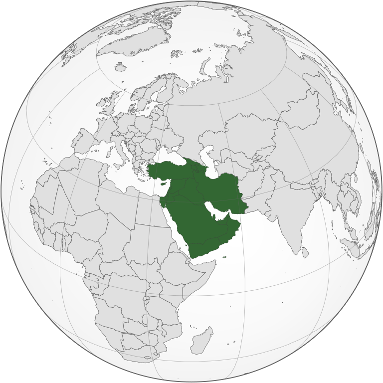
English: West Asia (orthographic projection) |
| Source | Own work |
| Author | Keepscases |
| SVG development | This
locator map was created with
Inkscape. |
Licensing
I, the copyright holder of this work, hereby publish it under the following licenses:
This file is licensed under the
Creative Commons
Attribution-Share Alike 3.0 Unported license.
- You are free:
- to share – to copy, distribute and transmit the work
- to remix – to adapt the work
- Under the following conditions:
- attribution – You must give appropriate credit, provide a link to the license, and indicate if changes were made. You may do so in any reasonable manner, but not in any way that suggests the licensor endorses you or your use.
- share alike – If you remix, transform, or build upon the material, you must distribute your contributions under the same or compatible license as the original.

|
Permission is granted to copy, distribute and/or modify this document under the terms of the GNU Free Documentation License, Version 1.2 or any later version published by the Free Software Foundation; with no Invariant Sections, no Front-Cover Texts, and no Back-Cover Texts. A copy of the license is included in the section entitled GNU Free Documentation License. |
You may select the license of your choice.
File history
Click on a date/time to view the file as it appeared at that time.
.svg&dir=prev)
.svg&offset=20170511142803)
.svg&offset=&limit=20)
.svg&offset=&limit=50)
.svg&offset=&limit=100)
.svg&offset=&limit=250)
.svg&offset=&limit=500)
| Date/Time | Thumbnail | Dimensions | User | Comment | |
|---|---|---|---|---|---|
| current | 08:33, 5 September 2022 |
| 683 × 683 (929 KB) | Рагин1987 | Final edit |
| 12:01, 4 September 2022 |
 | 683 × 683 (927 KB) | Рагин1987 | Correction | |
| 18:50, 31 August 2022 |
 | 2,048 × 2,048 (1.05 MB) | Рагин1987 | Small correction | |
| 15:11, 31 August 2022 |
 | 2,048 × 2,048 (1.05 MB) | Рагин1987 | Small correction (Socotra Island is geologically closer to Africa) | |
| 18:45, 30 August 2022 |
 | 2,048 × 2,048 (1.05 MB) | Рагин1987 | More correct visualization of the dividing line on the territory of the Caucasus Range | |
| 14:21, 16 November 2019 |
 | 683 × 683 (919 KB) | Afrogindahood | Fixed some border errors | |
| 13:05, 16 November 2019 |
 | 512 × 512 (502 KB) | Afrogindahood | Fixed the gradient background not shown in the previous version | |
| 03:18, 31 October 2019 |
 | 737 × 737 (834 KB) | Afrogindahood | Added Gaza Strip, Sinai Peninsula which is still part of Asia and removed Eastern Thrace which is part of Southeastern Europe | |
| 18:09, 11 May 2017 |
 | 553 × 553 (332 KB) | LouisAragon | Rv disruption. 1 contradicted subdepartment means absolutely nothing. | |
| 14:28, 11 May 2017 |
 | 590 × 590 (410 KB) | Jcfidy | Quito Irán [http://data.un.org/CountryProfile.aspx?crName=Iran%20%28Islamic%20Republic%20of%29 referencia] |
File usage
The following pages on the English Wikipedia use this file (pages on other projects are not listed):
- Asian cuisine
- List of Asian cuisines
- List of conflicts in the Near East
- West Asia
- Talk:Arab Spring/Archive 8
- User:1992 FARHAAD
- User:Askhaiz
- User:Bohemian Baltimore
- User:Buaidh/Test4
- User:Equalwidth
- User:EuroMalena
- User:Irtapil/Interesting Projects
- User:Kharbaan Ghaltaan
- User:Persian-art-and-culture
- User:SGJ1991
- User:Sam7819/subpage
- User:SomeGuyWhoRandomlyEdits/List of conflicts in the Near East
- User:The Amir husein yazdani
- User:Zifrs69
- User:Ziraro
- User:좀비 브렌다
- User talk:Danloud
- Wikipedia:Userboxes/Location/Asia
- Wikipedia:Userboxes/Location/Asia/Regions
- Wikipedia:Userboxes/WikiProjects/Regional/11
- Wikipedia:Userboxes/WikiProjects/alphabetical/30
- Wikipedia:WikiProject Western Asia
- Template:User WP Western Asia
- Template:User WP Western Asia/doc
- Template:User Western Asian ancestry
- Template:User Western Asian ancestry/doc
- Template:User from Southwest Asia
- Template:User from Southwest Asia/doc
- Template:User from Western Asia
- Template:User from Western Asia/doc
- Template:User in Southwest Asia
- Template:User in Southwest Asia/doc
- Template:User in Southwest Asia/doc1
- Template:User in West Asia
- Template:User in West Asia/doc
- Template:User in West Asia/doc1
- Template:User interest Southwest Asia
- Template:User interest Southwest Asia/doc
- Template:User interest Western Asia
- Template:User interest Western Asia/doc
- Template:User proud Western Asian
- Template:User proud Western Asian/doc
- Template talk:Countries of Asia
- Category:Biota of West Asia
- Category:Fauna of West Asia
- Category:Geography of West Asia
- Category:West Asian Wikipedians
- Category:West Asian countries
- Category:WikiProject Western Asia participants
- Category:Wikipedians in West Asia
- Category:Wikipedians interested in West Asia
Global file usage
The following other wikis use this file:
- Usage on ab.wikipedia.org
- Usage on af.wikipedia.org
- Usage on ar.wikipedia.org
- Usage on ast.wikipedia.org
- Usage on av.wikipedia.org
- Usage on azb.wikipedia.org
- Usage on ba.wikipedia.org
- Usage on be.wikipedia.org
- Usage on bg.wikipedia.org
- Usage on bn.wikipedia.org
- Usage on br.wikipedia.org
- Usage on bs.wikipedia.org
- Usage on bxr.wikipedia.org
- Usage on ca.wikipedia.org
- Usage on cdo.wikipedia.org
- Usage on cs.wikipedia.org
- Usage on cv.wikipedia.org
- Usage on cy.wikipedia.org
- Usage on da.wikipedia.org
- Usage on de.wikipedia.org
- Usage on de.wiktionary.org
- Usage on diq.wikipedia.org
- Usage on el.wikipedia.org
- Usage on en.wiktionary.org
- Usage on eo.wikipedia.org
- Usage on es.wikipedia.org
- Usage on et.wikipedia.org
- Usage on eu.wikipedia.org
- Usage on fa.wikipedia.org
- Usage on fi.wikipedia.org
- Usage on frr.wikipedia.org
- Usage on fr.wikipedia.org
View more global usage of this file.
.svg)
Metadata
.svg)
Size of this PNG preview of this SVG file:
600 × 600 pixels. Other resolutions:
240 × 240 pixels |
480 × 480 pixels |
768 × 768 pixels |
1,024 × 1,024 pixels |
2,048 × 2,048 pixels |
683 × 683 pixels.
Original file (SVG file, nominally 683 × 683 pixels, file size: 929 KB)
| This is a file from the
Wikimedia Commons. Information from its
description page there is shown below. Commons is a freely licensed media file repository. You can help. |
بيلسان
Summary
| Description |
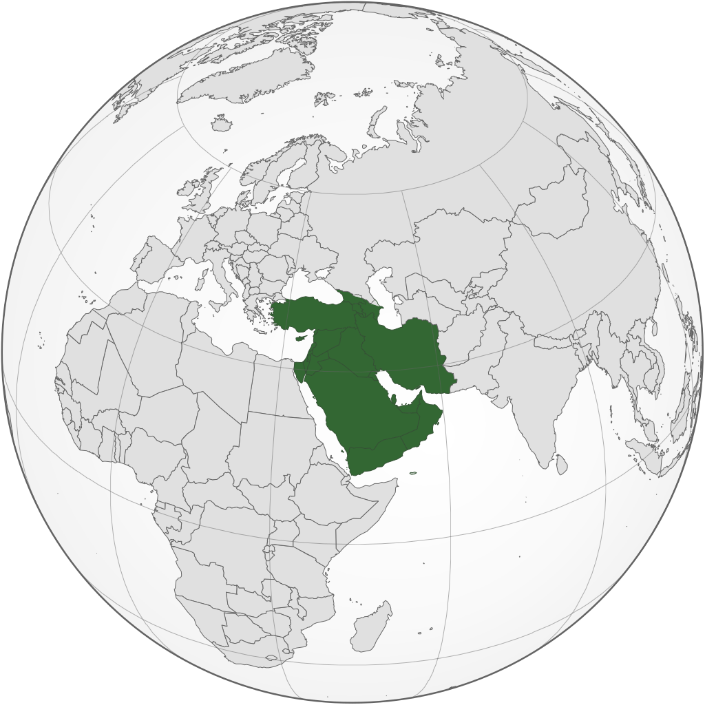
English: West Asia (orthographic projection) |
| Source | Own work |
| Author | Keepscases |
| SVG development | This
locator map was created with
Inkscape. |
Licensing
I, the copyright holder of this work, hereby publish it under the following licenses:
This file is licensed under the
Creative Commons
Attribution-Share Alike 3.0 Unported license.
- You are free:
- to share – to copy, distribute and transmit the work
- to remix – to adapt the work
- Under the following conditions:
- attribution – You must give appropriate credit, provide a link to the license, and indicate if changes were made. You may do so in any reasonable manner, but not in any way that suggests the licensor endorses you or your use.
- share alike – If you remix, transform, or build upon the material, you must distribute your contributions under the same or compatible license as the original.
|
|
Permission is granted to copy, distribute and/or modify this document under the terms of the GNU Free Documentation License, Version 1.2 or any later version published by the Free Software Foundation; with no Invariant Sections, no Front-Cover Texts, and no Back-Cover Texts. A copy of the license is included in the section entitled GNU Free Documentation License. |
You may select the license of your choice.
File history
Click on a date/time to view the file as it appeared at that time.
| Date/Time | Thumbnail | Dimensions | User | Comment | |
|---|---|---|---|---|---|
| current | 08:33, 5 September 2022 |
| 683 × 683 (929 KB) | Рагин1987 | Final edit |
| 12:01, 4 September 2022 |
| 683 × 683 (927 KB) | Рагин1987 | Correction | |
| 18:50, 31 August 2022 |
| 2,048 × 2,048 (1.05 MB) | Рагин1987 | Small correction | |
| 15:11, 31 August 2022 |
| 2,048 × 2,048 (1.05 MB) | Рагин1987 | Small correction (Socotra Island is geologically closer to Africa) | |
| 18:45, 30 August 2022 |
| 2,048 × 2,048 (1.05 MB) | Рагин1987 | More correct visualization of the dividing line on the territory of the Caucasus Range | |
| 14:21, 16 November 2019 |
| 683 × 683 (919 KB) | Afrogindahood | Fixed some border errors | |
| 13:05, 16 November 2019 |
| 512 × 512 (502 KB) | Afrogindahood | Fixed the gradient background not shown in the previous version | |
| 03:18, 31 October 2019 |
| 737 × 737 (834 KB) | Afrogindahood | Added Gaza Strip, Sinai Peninsula which is still part of Asia and removed Eastern Thrace which is part of Southeastern Europe | |
| 18:09, 11 May 2017 |
| 553 × 553 (332 KB) | LouisAragon | Rv disruption. 1 contradicted subdepartment means absolutely nothing. | |
| 14:28, 11 May 2017 |
| 590 × 590 (410 KB) | Jcfidy | Quito Irán [http://data.un.org/CountryProfile.aspx?crName=Iran%20%28Islamic%20Republic%20of%29 referencia] |
File usage
The following pages on the English Wikipedia use this file (pages on other projects are not listed):
- Asian cuisine
- List of Asian cuisines
- List of conflicts in the Near East
- West Asia
- Talk:Arab Spring/Archive 8
- User:1992 FARHAAD
- User:Askhaiz
- User:Bohemian Baltimore
- User:Buaidh/Test4
- User:Equalwidth
- User:EuroMalena
- User:Irtapil/Interesting Projects
- User:Kharbaan Ghaltaan
- User:Persian-art-and-culture
- User:SGJ1991
- User:Sam7819/subpage
- User:SomeGuyWhoRandomlyEdits/List of conflicts in the Near East
- User:The Amir husein yazdani
- User:Zifrs69
- User:Ziraro
- User:좀비 브렌다
- User talk:Danloud
- Wikipedia:Userboxes/Location/Asia
- Wikipedia:Userboxes/Location/Asia/Regions
- Wikipedia:Userboxes/WikiProjects/Regional/11
- Wikipedia:Userboxes/WikiProjects/alphabetical/30
- Wikipedia:WikiProject Western Asia
- Template:User WP Western Asia
- Template:User WP Western Asia/doc
- Template:User Western Asian ancestry
- Template:User Western Asian ancestry/doc
- Template:User from Southwest Asia
- Template:User from Southwest Asia/doc
- Template:User from Western Asia
- Template:User from Western Asia/doc
- Template:User in Southwest Asia
- Template:User in Southwest Asia/doc
- Template:User in Southwest Asia/doc1
- Template:User in West Asia
- Template:User in West Asia/doc
- Template:User in West Asia/doc1
- Template:User interest Southwest Asia
- Template:User interest Southwest Asia/doc
- Template:User interest Western Asia
- Template:User interest Western Asia/doc
- Template:User proud Western Asian
- Template:User proud Western Asian/doc
- Template talk:Countries of Asia
- Category:Biota of West Asia
- Category:Fauna of West Asia
- Category:Geography of West Asia
- Category:West Asian Wikipedians
- Category:West Asian countries
- Category:WikiProject Western Asia participants
- Category:Wikipedians in West Asia
- Category:Wikipedians interested in West Asia
Global file usage
The following other wikis use this file:
- Usage on ab.wikipedia.org
- Usage on af.wikipedia.org
- Usage on ar.wikipedia.org
- Usage on ast.wikipedia.org
- Usage on av.wikipedia.org
- Usage on azb.wikipedia.org
- Usage on ba.wikipedia.org
- Usage on be.wikipedia.org
- Usage on bg.wikipedia.org
- Usage on bn.wikipedia.org
- Usage on br.wikipedia.org
- Usage on bs.wikipedia.org
- Usage on bxr.wikipedia.org
- Usage on ca.wikipedia.org
- Usage on cdo.wikipedia.org
- Usage on cs.wikipedia.org
- Usage on cv.wikipedia.org
- Usage on cy.wikipedia.org
- Usage on da.wikipedia.org
- Usage on de.wikipedia.org
- Usage on de.wiktionary.org
- Usage on diq.wikipedia.org
- Usage on el.wikipedia.org
- Usage on en.wiktionary.org
- Usage on eo.wikipedia.org
- Usage on es.wikipedia.org
- Usage on et.wikipedia.org
- Usage on eu.wikipedia.org
- Usage on fa.wikipedia.org
- Usage on fi.wikipedia.org
- Usage on frr.wikipedia.org
- Usage on fr.wikipedia.org
View more global usage of this file.