
Original file (SVG file, nominally 2,068 × 1,508 pixels, file size: 214 KB)
| This is a file from the
Wikimedia Commons. Information from its
description page there is shown below. Commons is a freely licensed media file repository. You can help. |
Summary
| Description |
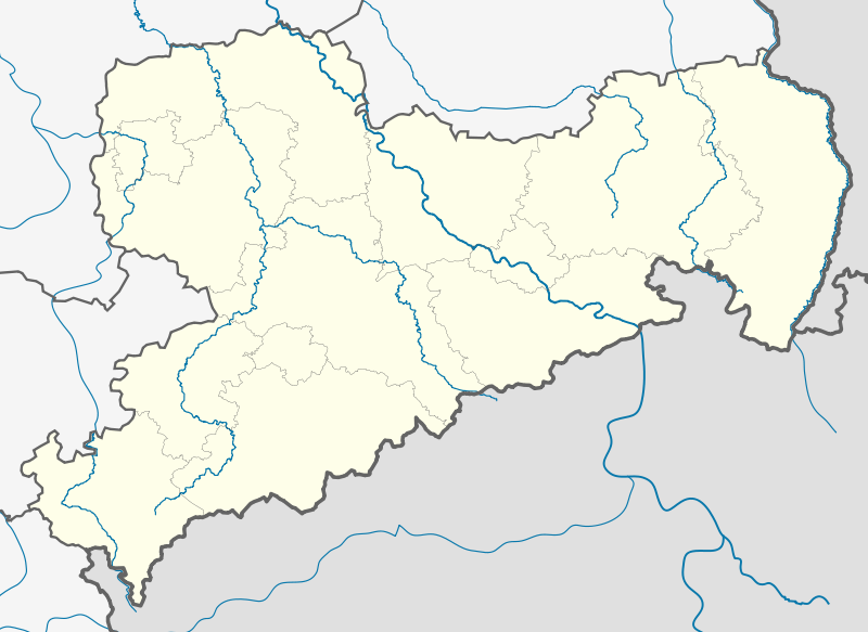
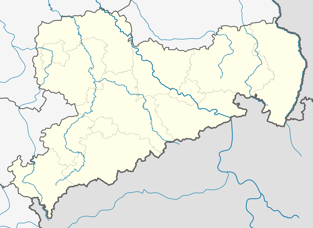
Deutsch: Positionskarte
Sachsen, Deutschland. Geographische Begrenzung der Karte:
English: Location map
Saxony, Germany. Geographic limits of the map:
|
| Date | |
| Source |
own work, templates |
| Author | TUBS |
| Other versions |
|
| SVG development |

Licensing

|
Permission is granted to copy, distribute and/or modify this document under the terms of the GNU Free Documentation License, Version 1.2 or any later version published by the Free Software Foundation; with no Invariant Sections, no Front-Cover Texts, and no Back-Cover Texts. A copy of the license is included in the section entitled GNU Free Documentation License. |
- You are free:
- to share – to copy, distribute and transmit the work
- to remix – to adapt the work
- Under the following conditions:
- attribution – You must give appropriate credit, provide a link to the license, and indicate if changes were made. You may do so in any reasonable manner, but not in any way that suggests the licensor endorses you or your use.
- share alike – If you remix, transform, or build upon the material, you must distribute your contributions under the same or compatible license as the original.
File history
Click on a date/time to view the file as it appeared at that time.
| Date/Time | Thumbnail | Dimensions | User | Comment | |
|---|---|---|---|---|---|
| current | 23:01, 28 August 2012 |
| 2,068 × 1,508 (214 KB) | TUBS | Nordgrenze korrigiert (insbesondere Nordostspitze von Ostsachsen) |
| 14:09, 7 April 2012 |
 | 2,068 × 1,508 (799 KB) | Inkowik | Direktionsbezirke entfernt | |
| 18:17, 30 January 2009 |
 | 2,068 × 1,508 (836 KB) | TUBS | added some rivers, corrected border thickness, rivers color, etc. | |
| 15:03, 30 January 2009 |
 | 2,068 × 1,508 (830 KB) | TUBS | added some rivers (excluded still most rivers outside saxony) | |
| 11:07, 30 January 2009 |
 | 2,068 × 1,508 (788 KB) | TUBS | == Summary == {{Information |Description= {{de|Positionskarte Sachsen, Deutschland. Geographische Begrenzung der Karte:}} {{en|Location map Saxony, Germany. Geographic limits of the map:}} * N: 53.xx° N * S: 50.xx° N * W |
File usage
More than 100 pages use this file. The following list shows the first 100 pages that use this file only. A full list is available.
- Adorf
- Annaberg-Buchholz
- Aue, Saxony
- Auerbach (Vogtland)
- Bad Gottleuba-Berggießhübel
- Bad Muskau
- Bad Schandau
- Bahretal
- Battle of Breitenfeld (1631)
- Bautzen
- Berthelsdorf
- Bischofswerda
- Blasewitz
- Borna, Leipzig
- Böhlen
- Chemnitz
- Colditz
- Coswig, Saxony
- Crimmitschau
- Delitzsch
- Dohna
- Dresden
- Dresden Airport
- Dresden Hauptbahnhof
- Döbeln
- Dürrröhrsdorf-Dittersbach
- Eibenstock
- Eilenburg
- Erlau
- Frankenberg, Saxony
- Fraureuth
- Freiberg
- Freital
- Glashütte
- Glauchau
- Grimma
- Großenhain
- Großhennersdorf
- Görlitz
- Hainichen, Saxony
- Hartmannsdorf, Mittelsachsen
- Haselbachtal
- Heidenau
- Herrnhut
- Hochkirch
- Hohenstein-Ernstthal
- Hoyerswerda
- Kamenz
- Kreischa
- Königstein, Saxony
- Leipzig
- Leipzig/Halle Airport
- Leipzig Bayerischer Bahnhof
- Leisnig
- Limbach-Oberfrohna
- Loschwitz
- Löbau
- Marienberg
- Markkleeberg
- Meerane
- Meissen
- Mittweida
- Moritzburg, Saxony
- Niesky
- Nossen
- Ore Mountains
- Oschatz
- Ostrau, Mittelsachsen
- Ottendorf-Okrilla
- Pegau
- Pillnitz
- Pirna
- Plauen
- Pockau
- Radeberg
- Radebeul
- Rathen
- Reichenbach (Oberlausitz)
- Reichenbach im Vogtland
- Riesa
- Rothenburg, Oberlausitz
- Roßwein
- Schkeuditz
- Schneeberg, Saxony
- Schwarzenberg, Saxony
- Sohland an der Spree
- Stollberg
- Stolpen
- Strehla
- Tannenberg, Saxony
- Taucha
- Tharandt
- Torgau
- Waldenburg, Saxony
- Weißwasser
- Werdau
- Wilsdruff
- Wurzen
- Zittau
- Zschadraß
View more links to this file.
Global file usage
The following other wikis use this file:
- Usage on ar.wikipedia.org
- Usage on azb.wikipedia.org
- Usage on az.wikipedia.org
- Usage on ba.wikipedia.org
- Августусбург
- Адорф (Фогтланд)
- Айбау
- Айбеншток
- Айленбург
- Айхигт
- Альтенберг (Мәғдән тауҙары)
- Альтмитвайда
- Амтсберг
- Аннаберг-Буххольц
- Арнсдорф
- Арцберг (Саксония)
- Ауэ (Саксония)
- Ауэрбах (Мәғдән тауҙары)
- Ауэрбах (Фогтланд)
- Бёзенбрунн
- Бёлен (Саксония)
- Бёрнихен (Мәғдән тауҙары)
- Бад-Брамбах
- Бад-Готлойба-Берггисхюбель
- Бад-Дюбен
- Бад-Лаузик
- Бад-Мускау
- Бад-Шандау
- Бад-Шлема
- Бад-Эльстер
- Байерсдорф
- Байльроде
- Банневиц
- Бареталь
- Бельгерн
- Бельгерсхайн
- Бенневиц
- Берген (Фогтланд)
- Беренштайн (Мәғдән тауҙары)
- Бернсбах
- Бернсдорф (Үрге Лужица)
- Бернсдорф (район Цвиккау)
- Бернштадт-на-Айгене
- Бертельсдорф
- Бертсдорф-Хёрниц
- Бишофсверда
- Бобрич
- Бокау
View more global usage of this file.
Original file (SVG file, nominally 2,068 × 1,508 pixels, file size: 214 KB)
| This is a file from the
Wikimedia Commons. Information from its
description page there is shown below. Commons is a freely licensed media file repository. You can help. |
Summary
| Description |
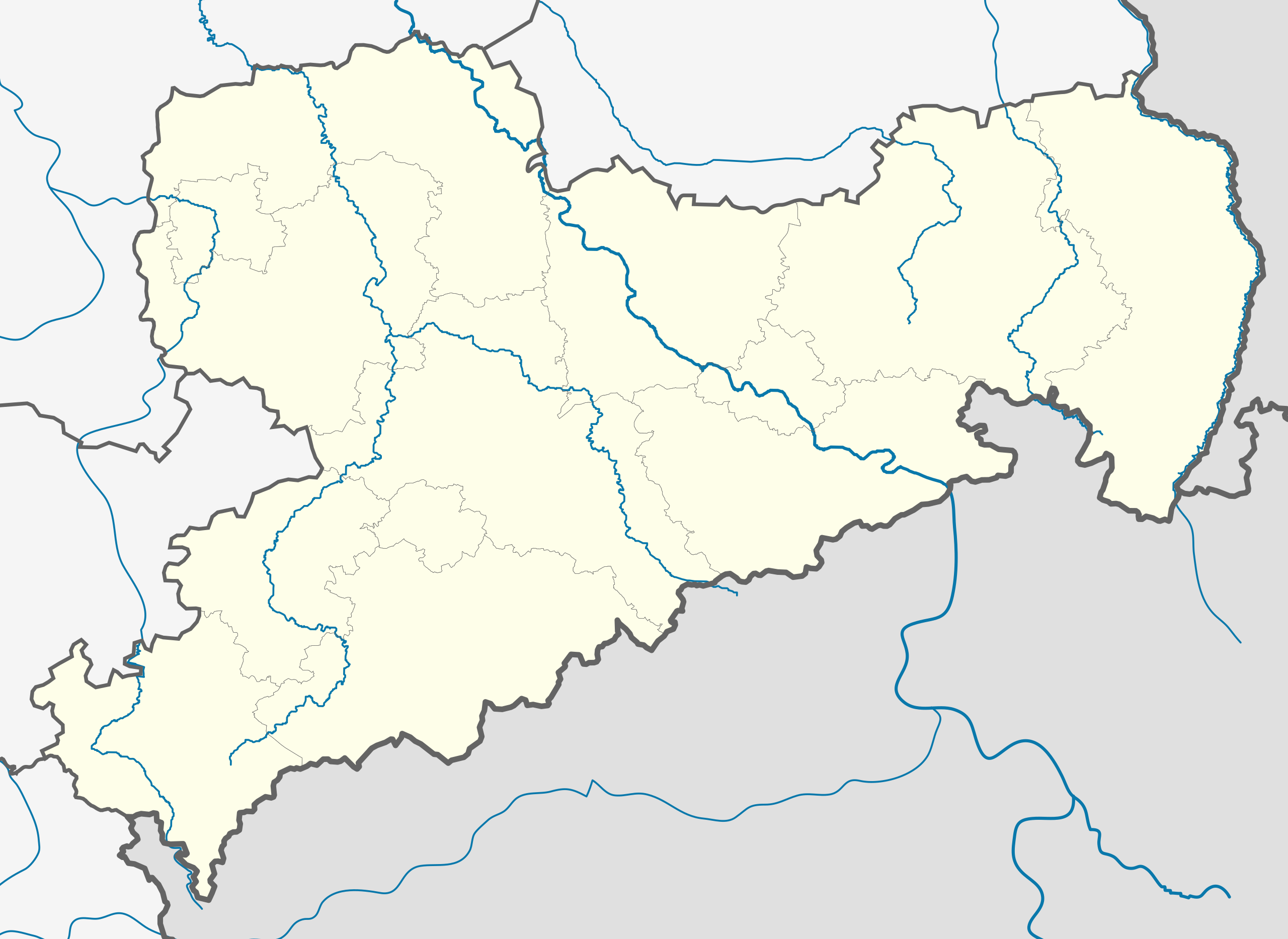
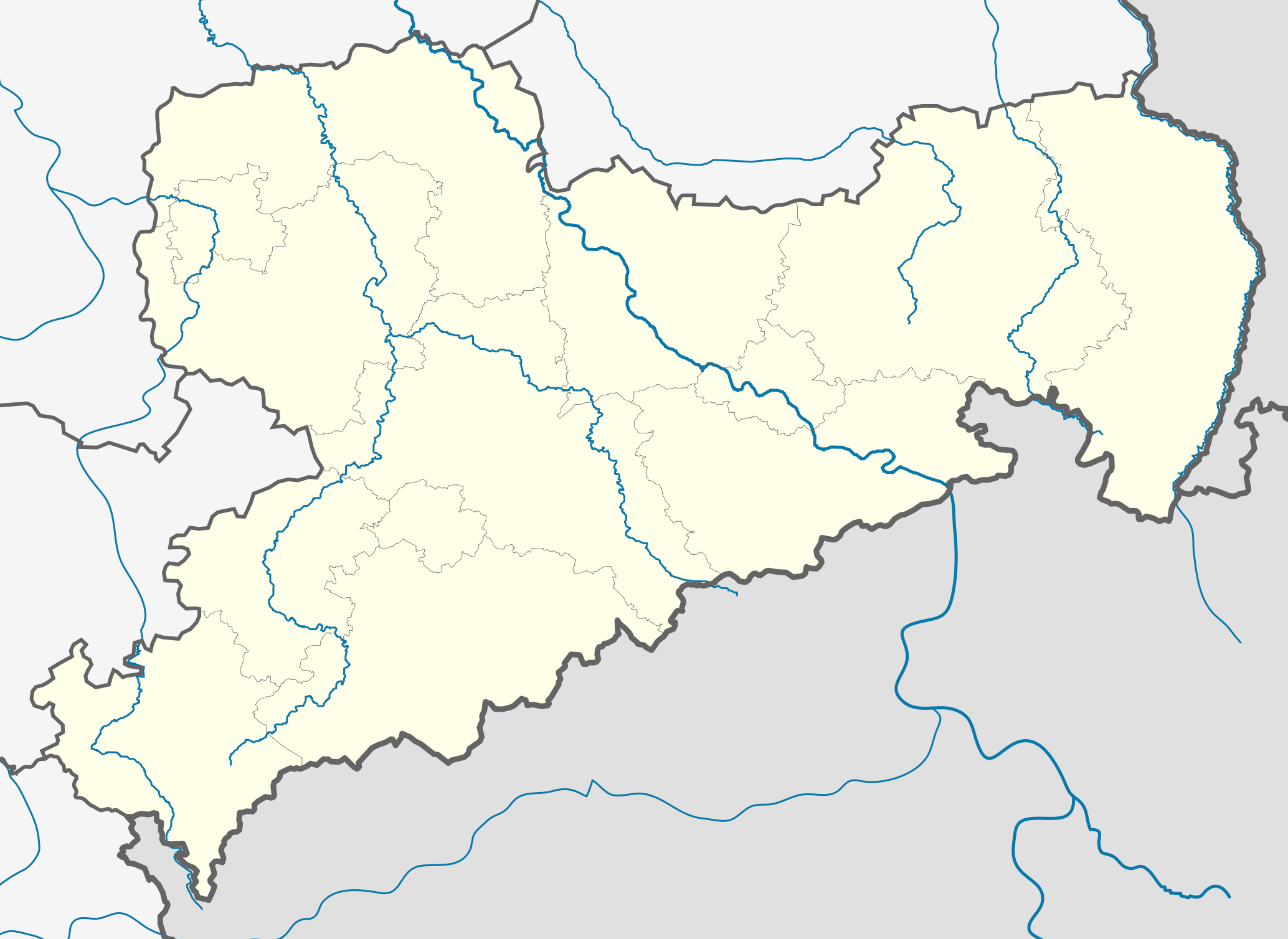
Deutsch: Positionskarte
Sachsen, Deutschland. Geographische Begrenzung der Karte:
English: Location map
Saxony, Germany. Geographic limits of the map:
|
| Date | |
| Source |
own work, templates |
| Author | TUBS |
| Other versions |
|
| SVG development |
Licensing
|
|
Permission is granted to copy, distribute and/or modify this document under the terms of the GNU Free Documentation License, Version 1.2 or any later version published by the Free Software Foundation; with no Invariant Sections, no Front-Cover Texts, and no Back-Cover Texts. A copy of the license is included in the section entitled GNU Free Documentation License. |
- You are free:
- to share – to copy, distribute and transmit the work
- to remix – to adapt the work
- Under the following conditions:
- attribution – You must give appropriate credit, provide a link to the license, and indicate if changes were made. You may do so in any reasonable manner, but not in any way that suggests the licensor endorses you or your use.
- share alike – If you remix, transform, or build upon the material, you must distribute your contributions under the same or compatible license as the original.
File history
Click on a date/time to view the file as it appeared at that time.
| Date/Time | Thumbnail | Dimensions | User | Comment | |
|---|---|---|---|---|---|
| current | 23:01, 28 August 2012 |
| 2,068 × 1,508 (214 KB) | TUBS | Nordgrenze korrigiert (insbesondere Nordostspitze von Ostsachsen) |
| 14:09, 7 April 2012 |
| 2,068 × 1,508 (799 KB) | Inkowik | Direktionsbezirke entfernt | |
| 18:17, 30 January 2009 |
| 2,068 × 1,508 (836 KB) | TUBS | added some rivers, corrected border thickness, rivers color, etc. | |
| 15:03, 30 January 2009 |
| 2,068 × 1,508 (830 KB) | TUBS | added some rivers (excluded still most rivers outside saxony) | |
| 11:07, 30 January 2009 |
| 2,068 × 1,508 (788 KB) | TUBS | == Summary == {{Information |Description= {{de|Positionskarte Sachsen, Deutschland. Geographische Begrenzung der Karte:}} {{en|Location map Saxony, Germany. Geographic limits of the map:}} * N: 53.xx° N * S: 50.xx° N * W |
File usage
More than 100 pages use this file. The following list shows the first 100 pages that use this file only. A full list is available.
- Adorf
- Annaberg-Buchholz
- Aue, Saxony
- Auerbach (Vogtland)
- Bad Gottleuba-Berggießhübel
- Bad Muskau
- Bad Schandau
- Bahretal
- Battle of Breitenfeld (1631)
- Bautzen
- Berthelsdorf
- Bischofswerda
- Blasewitz
- Borna, Leipzig
- Böhlen
- Chemnitz
- Colditz
- Coswig, Saxony
- Crimmitschau
- Delitzsch
- Dohna
- Dresden
- Dresden Airport
- Dresden Hauptbahnhof
- Döbeln
- Dürrröhrsdorf-Dittersbach
- Eibenstock
- Eilenburg
- Erlau
- Frankenberg, Saxony
- Fraureuth
- Freiberg
- Freital
- Glashütte
- Glauchau
- Grimma
- Großenhain
- Großhennersdorf
- Görlitz
- Hainichen, Saxony
- Hartmannsdorf, Mittelsachsen
- Haselbachtal
- Heidenau
- Herrnhut
- Hochkirch
- Hohenstein-Ernstthal
- Hoyerswerda
- Kamenz
- Kreischa
- Königstein, Saxony
- Leipzig
- Leipzig/Halle Airport
- Leipzig Bayerischer Bahnhof
- Leisnig
- Limbach-Oberfrohna
- Loschwitz
- Löbau
- Marienberg
- Markkleeberg
- Meerane
- Meissen
- Mittweida
- Moritzburg, Saxony
- Niesky
- Nossen
- Ore Mountains
- Oschatz
- Ostrau, Mittelsachsen
- Ottendorf-Okrilla
- Pegau
- Pillnitz
- Pirna
- Plauen
- Pockau
- Radeberg
- Radebeul
- Rathen
- Reichenbach (Oberlausitz)
- Reichenbach im Vogtland
- Riesa
- Rothenburg, Oberlausitz
- Roßwein
- Schkeuditz
- Schneeberg, Saxony
- Schwarzenberg, Saxony
- Sohland an der Spree
- Stollberg
- Stolpen
- Strehla
- Tannenberg, Saxony
- Taucha
- Tharandt
- Torgau
- Waldenburg, Saxony
- Weißwasser
- Werdau
- Wilsdruff
- Wurzen
- Zittau
- Zschadraß
View more links to this file.
Global file usage
The following other wikis use this file:
- Usage on ar.wikipedia.org
- Usage on azb.wikipedia.org
- Usage on az.wikipedia.org
- Usage on ba.wikipedia.org
- Августусбург
- Адорф (Фогтланд)
- Айбау
- Айбеншток
- Айленбург
- Айхигт
- Альтенберг (Мәғдән тауҙары)
- Альтмитвайда
- Амтсберг
- Аннаберг-Буххольц
- Арнсдорф
- Арцберг (Саксония)
- Ауэ (Саксония)
- Ауэрбах (Мәғдән тауҙары)
- Ауэрбах (Фогтланд)
- Бёзенбрунн
- Бёлен (Саксония)
- Бёрнихен (Мәғдән тауҙары)
- Бад-Брамбах
- Бад-Готлойба-Берггисхюбель
- Бад-Дюбен
- Бад-Лаузик
- Бад-Мускау
- Бад-Шандау
- Бад-Шлема
- Бад-Эльстер
- Байерсдорф
- Байльроде
- Банневиц
- Бареталь
- Бельгерн
- Бельгерсхайн
- Бенневиц
- Берген (Фогтланд)
- Беренштайн (Мәғдән тауҙары)
- Бернсбах
- Бернсдорф (Үрге Лужица)
- Бернсдорф (район Цвиккау)
- Бернштадт-на-Айгене
- Бертельсдорф
- Бертсдорф-Хёрниц
- Бишофсверда
- Бобрич
- Бокау
View more global usage of this file.