
Original file (1,988 × 1,509 pixels, file size: 2.76 MB, MIME type: image/png)
| This is a file from the
Wikimedia Commons. Information from its
description page there is shown below. Commons is a freely licensed media file repository. You can help. |
| Description |
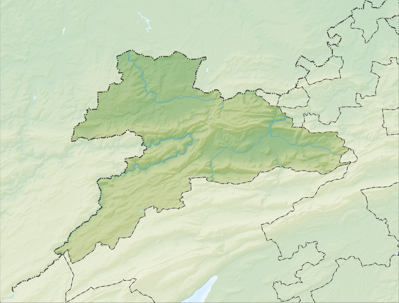
Deutsch: Reliefkarte des Kantons Jura
Topographischer Hintergrund:
NASA Shuttle Radar Topography Mission (public domain). SRTM3 v.2. |
||||||||
| Date | |||||||||
| Source | Own work | ||||||||
| Author | Tschubby | ||||||||
| Permission ( Reusing this file) |
I, the copyright holder of this work, hereby publish it under the following licenses:
This file is licensed under the
Creative Commons Attribution-Share Alike
2.5 Generic,
2.0 Generic and
1.0 Generic license.
You may select the license of your choice. |
||||||||
| Other versions |
 |

File history
Click on a date/time to view the file as it appeared at that time.
| Date/Time | Thumbnail | Dimensions | User | Comment | |
|---|---|---|---|---|---|
| current | 06:44, 6 December 2013 |
| 1,988 × 1,509 (2.76 MB) | Tschubby | {{Information |Description= {{de| Reliefkarte des Kantons Jura}} Topographischer Hintergrund: [http://www2.jpl.nasa.gov/srtm NASA Shuttle Radar Topography Mission] (public domain). SRTM3 v.2. |Source={{own}} |Date= 2013-12-06 |Author= [[:de:User:Tschub... |
File usage
More than 100 pages use this file. The following list shows the first 100 pages that use this file only. A full list is available.
- Alle, Switzerland
- Asuel
- Basse-Allaine
- Bassecourt
- Bassecourt railway station
- Beurnevésin
- Boncourt, Switzerland
- Bonfol
- Bourrignon
- Boécourt
- Bressaucourt
- Buix
- Bure, Switzerland
- Charmoille, Switzerland
- Chevenez
- Châtillon, Canton of Jura
- Clos du Doubs
- Coeuve
- Corban, Switzerland
- Cornol
- Courchapoix
- Courchavon
- Courfaivre
- Courfaivre railway station
- Courgenay
- Courgenay railway station
- Courrendlin
- Courroux
- Courtedoux
- Courtemaîche
- Courtételle
- Courtételle railway station
- Damphreux
- Damvant
- Delémont
- Delémont railway station
- Develier
- Ederswiler
- Epauvillers
- Epiquerez
- Etang de la Gruère
- Etangs de Bonfol
- Fahy
- Fontenais
- Fregiécourt
- Glovelier
- Goumois
- Grandfontaine, Switzerland
- Haute-Ajoie
- Haute-Sorne
- La Baroche
- La Chaux-des-Breuleux
- Lajoux, Switzerland
- Le Bémont
- Le Noirmont
- Le Peuchapatte
- Les Bois
- Les Breuleux
- Les Enfers
- Les Genevez
- Les Pommerats
- List of castles and fortresses in Switzerland
- Lugnez
- Mervelier
- Mettembert
- Miécourt
- Montenol
- Montfaucon, Switzerland
- Montfavergier
- Montignez
- Montmelon
- Montsevelier
- Movelier
- Muriaux
- Ocourt
- Pleigne
- Pleujouse
- Porrentruy
- Porrentruy railway station
- Prince-Bishops' Castle (Delémont)
- Rebeuvelier
- Roche-d'Or
- Rocourt, Jura
- Rossemaison
- Réclère
- Saignelégier
- Saint-Brais
- Saint-Ursanne
- Saulcy, Switzerland
- Seleute
- Soubey
- Soulce
- Soyhières
- St-Ursanne railway station
- Undervelier
- Val Terbi
- Vellerat
- Vendlincourt
- Vermes, Switzerland
- Vicques, Switzerland
View more links to this file.
Global file usage
The following other wikis use this file:
- Usage on de.wikipedia.org
- Mont Terri
- Scheltenbach
- Col des Rangiers
- Sender Les Ordons
- Delsberger Becken
- Liste von Burgen und Schlössern in der Schweiz
- Étang de la Gruère
- Löwenburg JU
- Wikipedia:Kartenwerkstatt/Positionskarten/Europa
- Vorlage:Positionskarte Schweiz Jura
- Aussichtsturm Faux d’Enson
- Aussichtsturm Mont Renaud
- Panoramaturm Pleigne
- Tabeillon
- Wikipedia:Kartenwerkstatt/Archiv/2017-12
- Benutzer:Tschubby/Reliefkarten
- Col de Montvoie
- Schloss Pruntrut
- Réfus-Turm
- Ruine Roche d’Or
- Étang de Bollement
- Schloss Pleujouse
- Ruine Milandre
- Usage on eo.wikipedia.org
- Usage on fr.wikipedia.org
- Les Breuleux
- Les Ordons
- Jura bernois
- Montchaibeux
- Ajoie
- Grottes de Réclère
- Mont Terri
- Canton du Jura
- Étang de la Gruère
- Utilisateur:Wikisoft*/Tests cartes
- Col des Rangiers
- Val Terbi (vallée)
- Col de la Croix (Jura)
- Mont Raimeux
- Modèle:Carte/Canton du Jura
- Modèle:Géolocalisation/Canton du Jura
- Prise de Porrentruy
- Modèle:Géolocdual/Canton du Jura
- Projet:Cartographie/Géolocalisation/Maintenance/Images des cantons suisses
- Roc au Corbeau
- Utilisateur:Wikisoft*/Projet:Cartographie/Géolocalisation/Maintenance/Images des cantons suisses
- Projet:Cartographie/Cartes standards/Suisse
- Parc naturel régional du Doubs
- Abbaye de Lucelle
View more global usage of this file.
Metadata
Original file (1,988 × 1,509 pixels, file size: 2.76 MB, MIME type: image/png)
| This is a file from the
Wikimedia Commons. Information from its
description page there is shown below. Commons is a freely licensed media file repository. You can help. |
| Description |
Deutsch: Reliefkarte des Kantons Jura
Topographischer Hintergrund:
NASA Shuttle Radar Topography Mission (public domain). SRTM3 v.2. |
||||||||
| Date | |||||||||
| Source | Own work | ||||||||
| Author | Tschubby | ||||||||
| Permission ( Reusing this file) |
I, the copyright holder of this work, hereby publish it under the following licenses:
This file is licensed under the
Creative Commons Attribution-Share Alike
2.5 Generic,
2.0 Generic and
1.0 Generic license.
You may select the license of your choice. |
||||||||
| Other versions |
|
File history
Click on a date/time to view the file as it appeared at that time.
| Date/Time | Thumbnail | Dimensions | User | Comment | |
|---|---|---|---|---|---|
| current | 06:44, 6 December 2013 |
| 1,988 × 1,509 (2.76 MB) | Tschubby | {{Information |Description= {{de| Reliefkarte des Kantons Jura}} Topographischer Hintergrund: [http://www2.jpl.nasa.gov/srtm NASA Shuttle Radar Topography Mission] (public domain). SRTM3 v.2. |Source={{own}} |Date= 2013-12-06 |Author= [[:de:User:Tschub... |
File usage
More than 100 pages use this file. The following list shows the first 100 pages that use this file only. A full list is available.
- Alle, Switzerland
- Asuel
- Basse-Allaine
- Bassecourt
- Bassecourt railway station
- Beurnevésin
- Boncourt, Switzerland
- Bonfol
- Bourrignon
- Boécourt
- Bressaucourt
- Buix
- Bure, Switzerland
- Charmoille, Switzerland
- Chevenez
- Châtillon, Canton of Jura
- Clos du Doubs
- Coeuve
- Corban, Switzerland
- Cornol
- Courchapoix
- Courchavon
- Courfaivre
- Courfaivre railway station
- Courgenay
- Courgenay railway station
- Courrendlin
- Courroux
- Courtedoux
- Courtemaîche
- Courtételle
- Courtételle railway station
- Damphreux
- Damvant
- Delémont
- Delémont railway station
- Develier
- Ederswiler
- Epauvillers
- Epiquerez
- Etang de la Gruère
- Etangs de Bonfol
- Fahy
- Fontenais
- Fregiécourt
- Glovelier
- Goumois
- Grandfontaine, Switzerland
- Haute-Ajoie
- Haute-Sorne
- La Baroche
- La Chaux-des-Breuleux
- Lajoux, Switzerland
- Le Bémont
- Le Noirmont
- Le Peuchapatte
- Les Bois
- Les Breuleux
- Les Enfers
- Les Genevez
- Les Pommerats
- List of castles and fortresses in Switzerland
- Lugnez
- Mervelier
- Mettembert
- Miécourt
- Montenol
- Montfaucon, Switzerland
- Montfavergier
- Montignez
- Montmelon
- Montsevelier
- Movelier
- Muriaux
- Ocourt
- Pleigne
- Pleujouse
- Porrentruy
- Porrentruy railway station
- Prince-Bishops' Castle (Delémont)
- Rebeuvelier
- Roche-d'Or
- Rocourt, Jura
- Rossemaison
- Réclère
- Saignelégier
- Saint-Brais
- Saint-Ursanne
- Saulcy, Switzerland
- Seleute
- Soubey
- Soulce
- Soyhières
- St-Ursanne railway station
- Undervelier
- Val Terbi
- Vellerat
- Vendlincourt
- Vermes, Switzerland
- Vicques, Switzerland
View more links to this file.
Global file usage
The following other wikis use this file:
- Usage on de.wikipedia.org
- Mont Terri
- Scheltenbach
- Col des Rangiers
- Sender Les Ordons
- Delsberger Becken
- Liste von Burgen und Schlössern in der Schweiz
- Étang de la Gruère
- Löwenburg JU
- Wikipedia:Kartenwerkstatt/Positionskarten/Europa
- Vorlage:Positionskarte Schweiz Jura
- Aussichtsturm Faux d’Enson
- Aussichtsturm Mont Renaud
- Panoramaturm Pleigne
- Tabeillon
- Wikipedia:Kartenwerkstatt/Archiv/2017-12
- Benutzer:Tschubby/Reliefkarten
- Col de Montvoie
- Schloss Pruntrut
- Réfus-Turm
- Ruine Roche d’Or
- Étang de Bollement
- Schloss Pleujouse
- Ruine Milandre
- Usage on eo.wikipedia.org
- Usage on fr.wikipedia.org
- Les Breuleux
- Les Ordons
- Jura bernois
- Montchaibeux
- Ajoie
- Grottes de Réclère
- Mont Terri
- Canton du Jura
- Étang de la Gruère
- Utilisateur:Wikisoft*/Tests cartes
- Col des Rangiers
- Val Terbi (vallée)
- Col de la Croix (Jura)
- Mont Raimeux
- Modèle:Carte/Canton du Jura
- Modèle:Géolocalisation/Canton du Jura
- Prise de Porrentruy
- Modèle:Géolocdual/Canton du Jura
- Projet:Cartographie/Géolocalisation/Maintenance/Images des cantons suisses
- Roc au Corbeau
- Utilisateur:Wikisoft*/Projet:Cartographie/Géolocalisation/Maintenance/Images des cantons suisses
- Projet:Cartographie/Cartes standards/Suisse
- Parc naturel régional du Doubs
- Abbaye de Lucelle
View more global usage of this file.