Haute-Ajoie | |
|---|---|
 Chevenez village | |
 Haute-Ajoie  Haute-Ajoie | |
| Coordinates: 47°23′N 07°00′E / 47.383°N 7.000°E | |
| Country | Switzerland |
| Canton | Jura |
| District | Porrentruy |
| Government | |
| • Mayor | Maire |
| Area | |
| • Total | 36.43 km2 (14.07 sq mi) |
| Elevation | 491 m (1,611 ft) |
| Population (31 December 2018)
[2] | |
| • Total | 1,095 |
| • Density | 30/km2 (78/sq mi) |
| Time zone | UTC+01:00 ( Central European Time) |
| • Summer ( DST) | UTC+02:00 ( Central European Summer Time) |
| Postal code(s) | 2906 |
| SFOS number | 6809 |
| ISO 3166 code | CH-JU |
| Surrounded by | Grandfontaine, Rocourt, Fahy, Bure, Courtedoux, Bressaucourt, Vaufrey (F), Montjoie-le-Château (F), Villars-lès-Blamont (F), Dannemarie (F), Montancy (F), Glère(F) |
| Website |
www SFSO statistics |
Haute-Ajoie (French pronunciation: [ot aʒwa]) is a municipality in the district of Porrentruy in the canton of Jura in Switzerland. It was founded on January 1, 2009 by the former municipalities of Chevenez, Damvant, Réclère and Roche-d'Or. [3]
On 1 January 2018 the former municipality of Rocourt merged into the municipality of Haute-Ajoie.


Haute-Ajoie has an area of 36.47 km2 (14.08 sq mi). [4] Of this area, 20.38 km2 (7.87 sq mi) or 55.9% is used for agricultural purposes, while 14.62 km2 (5.64 sq mi) or 40.1% is forested. Of the rest of the land, 1.45 km2 (0.56 sq mi) or 4.0% is settled (buildings or roads) and 0.01 km2 (2.5 acres) or 0.0% is unproductive land. [5]
Of the built up area, housing and buildings made up 1.8% and transportation infrastructure made up 1.4%. Out of the forested land, 36.5% of the total land area is heavily forested and 3.6% is covered with orchards or small clusters of trees. Of the agricultural land, 25.4% is used for growing crops and 25.9% is pastures and 3.8% is used for alpine pastures. [5]
Haute-Ajoie has a population (as of December 2020 [update]) of 6,557. [6] As of 2010 [update], 7.7% of the population are resident foreign nationals. [7] Over the last 10 years (2000–2010) the population has changed at a rate of -2.4%. Migration accounted for 0.2%, while births and deaths accounted for -0.8%. [8]
Most of the population (as of 2000 [update]) speaks French (91.5%) as their first language, German is the second most common (6.8%) and Italian is the third (0.4%). [8]
As of 2008 [update], the population was 50.3% male and 49.7% female. The population was made up of 460 Swiss men (46.1% of the population) and 41 (4.1%) non-Swiss men. There were 460 Swiss women (46.1%) and 36 (3.6%) non-Swiss women. [7] As of 2000 [update], children and teenagers (0–19 years old) make up 25.6% of the population, while adults (20–64 years old) make up 55.6% and seniors (over 64 years old) make up 18.8%. [8]
As of 2009 [update], the construction rate of new housing units was 1 new units per 1000 residents. [8] The vacancy rate for the municipality, in 2010 [update], was 3.31%. [8]
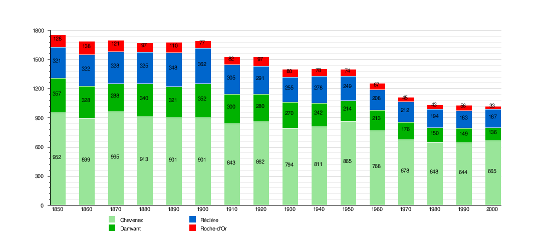
The historical population is given in the following chart: [9]
The entire village of Chevenez is designated as part of the Inventory of Swiss Heritage Sites. [10]
As of 2010 [update], Haute-Ajoie had an unemployment rate of 4.4%. As of 2008 [update], there were 122 people employed in the primary economic sector and about 41 businesses involved in this sector. 413 people were employed in the secondary sector and there were 6 businesses in this sector. 92 people were employed in the tertiary sector, with 21 businesses in this sector. [8] Of the working population, 7.5% used public transportation to get to work, and 57% used a private car. [8]
In the 2007 federal election the most popular party was the CVP which received 42.4% of the vote. The next three most popular parties were the SPS (29.4%), the SVP (14%) and the FDP (11.5%). [8]
The Canton of Jura school system provides two year of non-obligatory Kindergarten, followed by six years of Primary school. This is followed by three years of obligatory lower Secondary school where the students are separated according to ability and aptitude. Following the lower Secondary students may attend a three or four year optional upper Secondary school followed by some form of Tertiary school or they may enter an apprenticeship. [11]
During the 2009-10 school year, there were a total of 123 students attending 8 classes in Haute-Ajoie. There were 2 kindergarten classes with a total of 27 students in the municipality. [12] The municipality had 6 primary classes and 96 students. [13] There are only nine Secondary schools in the canton, so all the students from Haute-Ajoie attend their secondary school in another municipality.
- ^ a b "Arealstatistik Standard - Gemeinden nach 4 Hauptbereichen". Federal Statistical Office. Retrieved 13 January 2019.
- ^ "Ständige Wohnbevölkerung nach Staatsangehörigkeitskategorie Geschlecht und Gemeinde; Provisorische Jahresergebnisse; 2018". Federal Statistical Office. 9 April 2019. Retrieved 11 April 2019.
- ^ Amtliches Gemeindeverzeichnis der Schweiz published by the Swiss Federal Statistical Office (in German) accessed 19 July 2011
- ^ Arealstatistik Standard - Gemeindedaten nach 4 Hauptbereichen
- ^ a b Swiss Federal Statistical Office-Land Use Statistics 2009 data (in German) accessed 25 March 2010
- ^ "Ständige und nichtständige Wohnbevölkerung nach institutionellen Gliederungen, Geburtsort und Staatsangehörigkeit". bfs.admin.ch (in German). Swiss Federal Statistical Office - STAT-TAB. 31 December 2020. Retrieved 21 September 2021.
- ^ a b Population résidante permanente des communes, selon le sexe et la nationalité, au 31 décembre 2010, canton du Jura Archived 2012-04-26 at the Wayback Machine pdf document from the Canton of Jura Statistical Office Archived 2012-12-04 at archive.today accessed 19 December 2011
- ^ a b c d e f g h Swiss Federal Statistical Office accessed 30-December-2011
- ^ Federal Statistical Office STAT-TAB Bevölkerungsentwicklung nach Region, 1850-2000 Archived 2012-03-17 at the Wayback Machine (in German) accessed 29 January 2011
- ^ "Kantonsliste A-Objekte". KGS Inventar (in German). Federal Office of Civil Protection. 2009. Archived from the original on 28 June 2010. Retrieved 25 April 2011.
- ^ EDK/CDIP/IDES (2010). Kantonale Schulstrukturen in der Schweiz und im Fürstentum Liechtenstein / Structures Scolaires Cantonales en Suisse et Dans la Principauté du Liechtenstein (PDF) (Report). Retrieved 24 June 2010.
- ^ Effectifs de l'école enfantine 2009-2010 Archived 2012-04-14 at the Wayback Machine (in French) accessed 19 December 2011
- ^ Effectifs de l'école primaire (in French) accessed 19 December 2011
Municipalities in
Porrentruy District, Switzerland | ||
|---|---|---|
Haute-Ajoie | |
|---|---|
|
Chevenez village | |
Haute-Ajoie Haute-Ajoie | |
| Coordinates: 47°23′N 07°00′E / 47.383°N 7.000°E | |
| Country | Switzerland |
| Canton | Jura |
| District | Porrentruy |
| Government | |
| • Mayor | Maire |
| Area | |
| • Total | 36.43 km2 (14.07 sq mi) |
| Elevation | 491 m (1,611 ft) |
| Population (31 December 2018)
[2] | |
| • Total | 1,095 |
| • Density | 30/km2 (78/sq mi) |
| Time zone | UTC+01:00 ( Central European Time) |
| • Summer ( DST) | UTC+02:00 ( Central European Summer Time) |
| Postal code(s) | 2906 |
| SFOS number | 6809 |
| ISO 3166 code | CH-JU |
| Surrounded by | Grandfontaine, Rocourt, Fahy, Bure, Courtedoux, Bressaucourt, Vaufrey (F), Montjoie-le-Château (F), Villars-lès-Blamont (F), Dannemarie (F), Montancy (F), Glère(F) |
| Website |
www SFSO statistics |
Haute-Ajoie (French pronunciation: [ot aʒwa]) is a municipality in the district of Porrentruy in the canton of Jura in Switzerland. It was founded on January 1, 2009 by the former municipalities of Chevenez, Damvant, Réclère and Roche-d'Or. [3]
On 1 January 2018 the former municipality of Rocourt merged into the municipality of Haute-Ajoie.
Haute-Ajoie has an area of 36.47 km2 (14.08 sq mi). [4] Of this area, 20.38 km2 (7.87 sq mi) or 55.9% is used for agricultural purposes, while 14.62 km2 (5.64 sq mi) or 40.1% is forested. Of the rest of the land, 1.45 km2 (0.56 sq mi) or 4.0% is settled (buildings or roads) and 0.01 km2 (2.5 acres) or 0.0% is unproductive land. [5]
Of the built up area, housing and buildings made up 1.8% and transportation infrastructure made up 1.4%. Out of the forested land, 36.5% of the total land area is heavily forested and 3.6% is covered with orchards or small clusters of trees. Of the agricultural land, 25.4% is used for growing crops and 25.9% is pastures and 3.8% is used for alpine pastures. [5]
Haute-Ajoie has a population (as of December 2020 [update]) of 6,557. [6] As of 2010 [update], 7.7% of the population are resident foreign nationals. [7] Over the last 10 years (2000–2010) the population has changed at a rate of -2.4%. Migration accounted for 0.2%, while births and deaths accounted for -0.8%. [8]
Most of the population (as of 2000 [update]) speaks French (91.5%) as their first language, German is the second most common (6.8%) and Italian is the third (0.4%). [8]
As of 2008 [update], the population was 50.3% male and 49.7% female. The population was made up of 460 Swiss men (46.1% of the population) and 41 (4.1%) non-Swiss men. There were 460 Swiss women (46.1%) and 36 (3.6%) non-Swiss women. [7] As of 2000 [update], children and teenagers (0–19 years old) make up 25.6% of the population, while adults (20–64 years old) make up 55.6% and seniors (over 64 years old) make up 18.8%. [8]
As of 2009 [update], the construction rate of new housing units was 1 new units per 1000 residents. [8] The vacancy rate for the municipality, in 2010 [update], was 3.31%. [8]
The historical population is given in the following chart: [9]
The entire village of Chevenez is designated as part of the Inventory of Swiss Heritage Sites. [10]
As of 2010 [update], Haute-Ajoie had an unemployment rate of 4.4%. As of 2008 [update], there were 122 people employed in the primary economic sector and about 41 businesses involved in this sector. 413 people were employed in the secondary sector and there were 6 businesses in this sector. 92 people were employed in the tertiary sector, with 21 businesses in this sector. [8] Of the working population, 7.5% used public transportation to get to work, and 57% used a private car. [8]
In the 2007 federal election the most popular party was the CVP which received 42.4% of the vote. The next three most popular parties were the SPS (29.4%), the SVP (14%) and the FDP (11.5%). [8]
The Canton of Jura school system provides two year of non-obligatory Kindergarten, followed by six years of Primary school. This is followed by three years of obligatory lower Secondary school where the students are separated according to ability and aptitude. Following the lower Secondary students may attend a three or four year optional upper Secondary school followed by some form of Tertiary school or they may enter an apprenticeship. [11]
During the 2009-10 school year, there were a total of 123 students attending 8 classes in Haute-Ajoie. There were 2 kindergarten classes with a total of 27 students in the municipality. [12] The municipality had 6 primary classes and 96 students. [13] There are only nine Secondary schools in the canton, so all the students from Haute-Ajoie attend their secondary school in another municipality.
- ^ a b "Arealstatistik Standard - Gemeinden nach 4 Hauptbereichen". Federal Statistical Office. Retrieved 13 January 2019.
- ^ "Ständige Wohnbevölkerung nach Staatsangehörigkeitskategorie Geschlecht und Gemeinde; Provisorische Jahresergebnisse; 2018". Federal Statistical Office. 9 April 2019. Retrieved 11 April 2019.
- ^ Amtliches Gemeindeverzeichnis der Schweiz published by the Swiss Federal Statistical Office (in German) accessed 19 July 2011
- ^ Arealstatistik Standard - Gemeindedaten nach 4 Hauptbereichen
- ^ a b Swiss Federal Statistical Office-Land Use Statistics 2009 data (in German) accessed 25 March 2010
- ^ "Ständige und nichtständige Wohnbevölkerung nach institutionellen Gliederungen, Geburtsort und Staatsangehörigkeit". bfs.admin.ch (in German). Swiss Federal Statistical Office - STAT-TAB. 31 December 2020. Retrieved 21 September 2021.
- ^ a b Population résidante permanente des communes, selon le sexe et la nationalité, au 31 décembre 2010, canton du Jura Archived 2012-04-26 at the Wayback Machine pdf document from the Canton of Jura Statistical Office Archived 2012-12-04 at archive.today accessed 19 December 2011
- ^ a b c d e f g h Swiss Federal Statistical Office accessed 30-December-2011
- ^ Federal Statistical Office STAT-TAB Bevölkerungsentwicklung nach Region, 1850-2000 Archived 2012-03-17 at the Wayback Machine (in German) accessed 29 January 2011
- ^ "Kantonsliste A-Objekte". KGS Inventar (in German). Federal Office of Civil Protection. 2009. Archived from the original on 28 June 2010. Retrieved 25 April 2011.
- ^ EDK/CDIP/IDES (2010). Kantonale Schulstrukturen in der Schweiz und im Fürstentum Liechtenstein / Structures Scolaires Cantonales en Suisse et Dans la Principauté du Liechtenstein (PDF) (Report). Retrieved 24 June 2010.
- ^ Effectifs de l'école enfantine 2009-2010 Archived 2012-04-14 at the Wayback Machine (in French) accessed 19 December 2011
- ^ Effectifs de l'école primaire (in French) accessed 19 December 2011
Municipalities in
Porrentruy District, Switzerland | ||
|---|---|---|