
Original file (1,200 × 1,071 pixels, file size: 941 KB, MIME type: image/jpeg)
| This is a file from the
Wikimedia Commons. Information from its
description page there is shown below. Commons is a freely licensed media file repository. You can help. |
Summary
| Description |
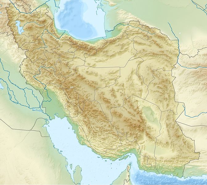
English: Location map of Iran.
Equirectangular projection. Strechted by 118.0%. Geographic limits of the map: * N: 40.0° N * S: 24.5° N * W: 43.5° E * E: 64.0° EMade with Natural Earth. Free vector and raster map data @ naturalearthdata.com. Deutsch: Topografische Karte des Iranischen Hochlandes mit der Verbindung zu Kleinasien im Westen und zum Hindukusch und Himalaya im Osten.
English: Topographic map of the
Iranian plateau in
Central Asia, connecting to
Anatolia in the west and
Hindu Kush and
Himalaya in the east.
Español: Mapa topográfico de la Meseta iraní. Mapa topográfico de la meseta iraní que enlaza Anatolia en el oeste con el Hindu Kush y el Himalaya en el Este.
Euskara: Irango goi-ordokiaren mapa topografikoa, Anatolia mendebaldean eta Hindu Kush eta Himalaia ekialdean.
فارسی: فلات ایران سرزمین مرتفعی است در همسایگی مناطق کم ارتفاع غرب، شمال و جنوب آسیا.
Français : Carte du plateau iranien en Asie, lié à l'Anatolie à l'ouest, et à l'Hindu Kush et à l'Himalaya à l'est.
한국어: 이란 고원의 서쪽으로는 아나톨리아로 연결되고, 동쪽으로는 힌두쿠시 산맥와 히말라야 산맥과 연결된다.
Nederlands: Kaart van het Hoogland van Iran in Azië, dat zich uitstrekt van Anatolië in het westen tot aan de Hindoekoesj en de Himalaya in het oosten.
Norsk bokmål: Topografisk kart over det iranske høylandet, som grenser til Anatolia i vest og Hindu Kush og Himalaya i øst.
پنجابی: سطح مرتفع ایران دا نقشہ ، لہندے چ اناطولیا تے چڑھدے چ کوہ ہندوکش تے ہمالیہ نال جڑئیا.
Português: Mapa topográfico do planalto iraniano ligando a Anatólia a oeste e o Hindu Kush e os Himalaias a este.
Русский: Иранское нагорье располагается между Аравийским полуостровом на западе и севером Индийского субконтинента на востоке.
Türkçe: Batıda Anadolu'ya doğuda ise Hindukuş ve Himalaya dağlarına bağlanan İran platosunun topografik haritası.
اردو: سطع مرتفع ایران کا نقشہ، مغرب میں اناطولیہ اور مشرق میں ہندوکش اور ہمالیہ سے منسلک.
Tiếng Việt: Bản đồ địa hình với sơn nguyên Iran nối Anatolia ở phía tây với Hindu Kush và Himalaya ở phía đông.
中文:伊朗高原地形圖,連接安納托利亞西部,東與喜馬拉雅山相鄰. |
| Date | |
| Source | Own work |
| Author | Uwe Dedering |
| Other versions |
|


Licensing
- You are free:
- to share – to copy, distribute and transmit the work
- to remix – to adapt the work
- Under the following conditions:
- attribution – You must give appropriate credit, provide a link to the license, and indicate if changes were made. You may do so in any reasonable manner, but not in any way that suggests the licensor endorses you or your use.
- share alike – If you remix, transform, or build upon the material, you must distribute your contributions under the same or compatible license as the original.

|
Permission is granted to copy, distribute and/or modify this document under the terms of the GNU Free Documentation License, Version 1.2 or any later version published by the Free Software Foundation; with no Invariant Sections, no Front-Cover Texts, and no Back-Cover Texts. A copy of the license is included in the section entitled GNU Free Documentation License. |
File history
Click on a date/time to view the file as it appeared at that time.
| Date/Time | Thumbnail | Dimensions | User | Comment | |
|---|---|---|---|---|---|
| current | 20:09, 11 July 2010 |
| 1,200 × 1,071 (941 KB) | Uwe Dedering | 31. province Alborz |
| 15:51, 23 April 2010 |
 | 1,200 × 1,071 (941 KB) | Uwe Dedering | {{Information |Description={{en|1=Location map of Iran. Equirectangular projection. Strechted by 118.0%. Geographic limits of the map: * N: 40.0° N * S: 24.5° N * W: 43.5° E * E: 64.0° E Made with Natural Earth. Free vector and raster map data @ |
File usage
More than 100 pages use this file. The following list shows the first 100 pages that use this file only. A full list is available.
- 1978 Tabas earthquake
- 2005 Qeshm earthquake
- 2005 Zarand earthquake
- 2006 Borujerd earthquake
- Abadan, Iran
- Abhar River
- Agha Bozorg Mosque
- Alam-Kuh
- Alamut Castle
- Ali-Sadr Cave
- Ali Qapu
- Alvand
- Alvares (ski resort)
- Anshan (Persia)
- Arg-e Bam
- Arg of Tabriz
- Atrek
- Bastam
- Battle of Aslanduz
- Battle of Chaldiran
- Battle of Gabiene
- Bazaar of Tabriz
- Bazman
- Behistun Inscription
- Blue Mosque, Tabriz
- Chehel Sotoun
- Chogha Zanbil
- Damghan
- Dasht-e Kavir
- Dasht-e Lut
- Dena
- Dez Dam
- Dizin
- Dome of Soltaniyeh
- Ecbatana
- Eram Garden
- Eshkaft-e Siahoo
- Falak-ol-Aflak
- Fatima Masumeh Shrine
- Fin Garden
- Garrin Mountain
- Goharshad Mosque
- Golestan Palace
- Gundeshapur
- Hamun Lake
- Imamzadeh Ja'far, Borujerd
- Iran Air Flight 655
- Isfahan
- Jameh Mosque of Borujerd
- Jameh Mosque of Nain
- Jameh Mosque of Qazvin
- Jiroft
- Jiroft culture
- Karun-3 Dam
- Kashan
- Kashmar
- Kavir National Park
- Kholeno
- Kish Island
- Lake Urmia
- Lar Dam
- Latyan Dam
- Lavan Island
- Maragheh
- Monastery of Saint Thaddeus
- Mount Binalud
- Mount Damavand
- Naqsh-e Jahan Square
- Naqsh-e Rostam
- Nasir-ol-Molk Mosque
- Nishapur
- Oshnavieh
- Persepolis
- Qal'eh Dokhtar
- Ray, Iran
- Sabalan
- Sahand
- Salmas
- Shah Abdol-Azim Shrine
- Shah Cheragh
- Shah Mosque (Isfahan)
- Shaho
- Shahr-e Sukhteh
- Sheikh Lotfollah Mosque
- Shir Kuh
- Shorabil Lake
- Shushtar
- Soltani Mosque of Borujerd
- Soltaniyeh
- Strait of Hormuz
- Susa
- Tabriz
- Taftan (volcano)
- Tandooreh National Park
- Taq-e Bostan
- Tehran
- Tepe Sialk
- Tochal
- Zabol
- Zard-Kuh
View more links to this file.
Global file usage
The following other wikis use this file:
- Usage on als.wikipedia.org
- Usage on ar.wikipedia.org
- Usage on ary.wikipedia.org
- Usage on ast.wikipedia.org
- Usage on av.wikipedia.org
- Usage on azb.wikipedia.org
- Usage on az.wikipedia.org
View more global usage of this file.
Original file (1,200 × 1,071 pixels, file size: 941 KB, MIME type: image/jpeg)
| This is a file from the
Wikimedia Commons. Information from its
description page there is shown below. Commons is a freely licensed media file repository. You can help. |
Summary
| Description |
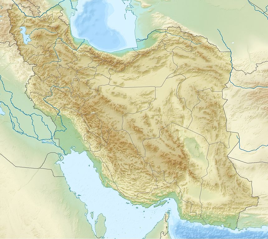
English: Location map of Iran.
Equirectangular projection. Strechted by 118.0%. Geographic limits of the map: * N: 40.0° N * S: 24.5° N * W: 43.5° E * E: 64.0° EMade with Natural Earth. Free vector and raster map data @ naturalearthdata.com. Deutsch: Topografische Karte des Iranischen Hochlandes mit der Verbindung zu Kleinasien im Westen und zum Hindukusch und Himalaya im Osten.
English: Topographic map of the
Iranian plateau in
Central Asia, connecting to
Anatolia in the west and
Hindu Kush and
Himalaya in the east.
Español: Mapa topográfico de la Meseta iraní. Mapa topográfico de la meseta iraní que enlaza Anatolia en el oeste con el Hindu Kush y el Himalaya en el Este.
Euskara: Irango goi-ordokiaren mapa topografikoa, Anatolia mendebaldean eta Hindu Kush eta Himalaia ekialdean.
فارسی: فلات ایران سرزمین مرتفعی است در همسایگی مناطق کم ارتفاع غرب، شمال و جنوب آسیا.
Français : Carte du plateau iranien en Asie, lié à l'Anatolie à l'ouest, et à l'Hindu Kush et à l'Himalaya à l'est.
한국어: 이란 고원의 서쪽으로는 아나톨리아로 연결되고, 동쪽으로는 힌두쿠시 산맥와 히말라야 산맥과 연결된다.
Nederlands: Kaart van het Hoogland van Iran in Azië, dat zich uitstrekt van Anatolië in het westen tot aan de Hindoekoesj en de Himalaya in het oosten.
Norsk bokmål: Topografisk kart over det iranske høylandet, som grenser til Anatolia i vest og Hindu Kush og Himalaya i øst.
پنجابی: سطح مرتفع ایران دا نقشہ ، لہندے چ اناطولیا تے چڑھدے چ کوہ ہندوکش تے ہمالیہ نال جڑئیا.
Português: Mapa topográfico do planalto iraniano ligando a Anatólia a oeste e o Hindu Kush e os Himalaias a este.
Русский: Иранское нагорье располагается между Аравийским полуостровом на западе и севером Индийского субконтинента на востоке.
Türkçe: Batıda Anadolu'ya doğuda ise Hindukuş ve Himalaya dağlarına bağlanan İran platosunun topografik haritası.
اردو: سطع مرتفع ایران کا نقشہ، مغرب میں اناطولیہ اور مشرق میں ہندوکش اور ہمالیہ سے منسلک.
Tiếng Việt: Bản đồ địa hình với sơn nguyên Iran nối Anatolia ở phía tây với Hindu Kush và Himalaya ở phía đông.
中文:伊朗高原地形圖,連接安納托利亞西部,東與喜馬拉雅山相鄰. |
| Date | |
| Source | Own work |
| Author | Uwe Dedering |
| Other versions |
|
Licensing
- You are free:
- to share – to copy, distribute and transmit the work
- to remix – to adapt the work
- Under the following conditions:
- attribution – You must give appropriate credit, provide a link to the license, and indicate if changes were made. You may do so in any reasonable manner, but not in any way that suggests the licensor endorses you or your use.
- share alike – If you remix, transform, or build upon the material, you must distribute your contributions under the same or compatible license as the original.
|
|
Permission is granted to copy, distribute and/or modify this document under the terms of the GNU Free Documentation License, Version 1.2 or any later version published by the Free Software Foundation; with no Invariant Sections, no Front-Cover Texts, and no Back-Cover Texts. A copy of the license is included in the section entitled GNU Free Documentation License. |
File history
Click on a date/time to view the file as it appeared at that time.
| Date/Time | Thumbnail | Dimensions | User | Comment | |
|---|---|---|---|---|---|
| current | 20:09, 11 July 2010 |
| 1,200 × 1,071 (941 KB) | Uwe Dedering | 31. province Alborz |
| 15:51, 23 April 2010 |
| 1,200 × 1,071 (941 KB) | Uwe Dedering | {{Information |Description={{en|1=Location map of Iran. Equirectangular projection. Strechted by 118.0%. Geographic limits of the map: * N: 40.0° N * S: 24.5° N * W: 43.5° E * E: 64.0° E Made with Natural Earth. Free vector and raster map data @ |
File usage
More than 100 pages use this file. The following list shows the first 100 pages that use this file only. A full list is available.
- 1978 Tabas earthquake
- 2005 Qeshm earthquake
- 2005 Zarand earthquake
- 2006 Borujerd earthquake
- Abadan, Iran
- Abhar River
- Agha Bozorg Mosque
- Alam-Kuh
- Alamut Castle
- Ali-Sadr Cave
- Ali Qapu
- Alvand
- Alvares (ski resort)
- Anshan (Persia)
- Arg-e Bam
- Arg of Tabriz
- Atrek
- Bastam
- Battle of Aslanduz
- Battle of Chaldiran
- Battle of Gabiene
- Bazaar of Tabriz
- Bazman
- Behistun Inscription
- Blue Mosque, Tabriz
- Chehel Sotoun
- Chogha Zanbil
- Damghan
- Dasht-e Kavir
- Dasht-e Lut
- Dena
- Dez Dam
- Dizin
- Dome of Soltaniyeh
- Ecbatana
- Eram Garden
- Eshkaft-e Siahoo
- Falak-ol-Aflak
- Fatima Masumeh Shrine
- Fin Garden
- Garrin Mountain
- Goharshad Mosque
- Golestan Palace
- Gundeshapur
- Hamun Lake
- Imamzadeh Ja'far, Borujerd
- Iran Air Flight 655
- Isfahan
- Jameh Mosque of Borujerd
- Jameh Mosque of Nain
- Jameh Mosque of Qazvin
- Jiroft
- Jiroft culture
- Karun-3 Dam
- Kashan
- Kashmar
- Kavir National Park
- Kholeno
- Kish Island
- Lake Urmia
- Lar Dam
- Latyan Dam
- Lavan Island
- Maragheh
- Monastery of Saint Thaddeus
- Mount Binalud
- Mount Damavand
- Naqsh-e Jahan Square
- Naqsh-e Rostam
- Nasir-ol-Molk Mosque
- Nishapur
- Oshnavieh
- Persepolis
- Qal'eh Dokhtar
- Ray, Iran
- Sabalan
- Sahand
- Salmas
- Shah Abdol-Azim Shrine
- Shah Cheragh
- Shah Mosque (Isfahan)
- Shaho
- Shahr-e Sukhteh
- Sheikh Lotfollah Mosque
- Shir Kuh
- Shorabil Lake
- Shushtar
- Soltani Mosque of Borujerd
- Soltaniyeh
- Strait of Hormuz
- Susa
- Tabriz
- Taftan (volcano)
- Tandooreh National Park
- Taq-e Bostan
- Tehran
- Tepe Sialk
- Tochal
- Zabol
- Zard-Kuh
View more links to this file.
Global file usage
The following other wikis use this file:
- Usage on als.wikipedia.org
- Usage on ar.wikipedia.org
- Usage on ary.wikipedia.org
- Usage on ast.wikipedia.org
- Usage on av.wikipedia.org
- Usage on azb.wikipedia.org
- Usage on az.wikipedia.org
View more global usage of this file.