Photos • Location
| Binalud | |
|---|---|
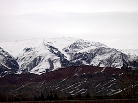
 Mt. Binalud view in winter from Bāghrud Road (south of the mountain). | |
| Highest point | |
| Elevation | 3,220 m (10,560 ft) [1] |
| Listing | Mountains of Iran |
| Coordinates | 36°25′35″N 58°50′57″E / 36.42639°N 58.84917°E |
| Geography | |
| Country | Iran |
| Province | Razavi Khorasan |
| Cities | Nishapur and Mashhad |
| Parent range | Binalud Mountains |
Mount Binālud (In Persian: بینالود) is a peak in Razavi Khorasan province in Iran. It is also known as the Roof of Khorasan.[ citation needed]
References
- ^ "Topographic map of Mount Binalud". opentopomap.org. Retrieved 2023-04-21.
External links
| Binalud | |
|---|---|
 Mt. Binalud view in winter from Bāghrud Road (south of the mountain). | |
| Highest point | |
| Elevation | 3,220 m (10,560 ft) [1] |
| Listing | Mountains of Iran |
| Coordinates | 36°25′35″N 58°50′57″E / 36.42639°N 58.84917°E |
| Geography | |
| Country | Iran |
| Province | Razavi Khorasan |
| Cities | Nishapur and Mashhad |
| Parent range | Binalud Mountains |
Mount Binālud (In Persian: بینالود) is a peak in Razavi Khorasan province in Iran. It is also known as the Roof of Khorasan.[ citation needed]
References
- ^ "Topographic map of Mount Binalud". opentopomap.org. Retrieved 2023-04-21.
